
The Gold Coast is a coastal city in the Australian state of Queensland, approximately 66 kilometres (41 mi) south-southeast of the centre of the state capital Brisbane and immediately north of the border with New South Wales. The traditional owners of this region of south-east Queensland are the Yugambeh language people. The demonym for the Gold Coast is Gold Coaster. With an estimated population of 679,127, at June 2019, the Gold Coast is the sixth-largest city in Australia, making it the largest non-capital city, and Queensland's second-largest city.

The City of Shoalhaven is a local government area in the south-eastern coastal region of New South Wales, Australia. The area is about 200 kilometres (120 mi) south of Sydney. The Princes Highway passes through the area, and the South Coast railway line traverses the northern section, terminating at Bomaderry. At the 2016 census, the population was 99,650.
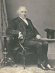
Alexander Berry was a Scottish-born surgeon, merchant and explorer who was given in 1822 a land grant of 10,000 acres (40 km2) and 100 convicts to establish the first European settlement on the south coast of New South Wales, Australia.

Milton is a village in the South Coast region of New South Wales, Australia, within the City of Shoalhaven. It was founded in 1860, named after the property of post master George Knight and became an important regional centre during the 19th Century. Today, Milton remains one of the two main commercial centres of the Milton-Ulladulla district, with a population at the 2016 census of 1,663. It is a popular stopping place for travellers on the Princes Highway which runs through the centre of town. In recent years, Milton has undergone a resurgence largely influenced by the local tourism industry and an influx of residents to the district seeking a seachange. Several new housing estates are being developed on the fringes of the village and new boutique stores, cafes and bed and breakfast type businesses have located in the town.
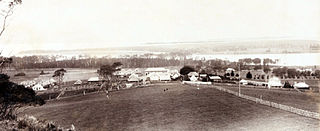
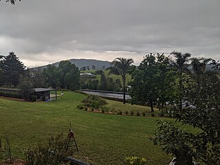
The Coolangatta Estate at Coolangatta, near Shoalhaven Heads was established in 1822 by Alexander Berry on the South Coast of New South Wales, Australia. Coolangatta Estate is located on the northern bank of the Shoalhaven River, in the foothills of a mountain called Coolangatta. The word 'Coolangatta' is from an aboriginal word which means either splendid view or good lookout. The estate today is in a picturesque setting overlooking the ocean and surrounded by vineyards.

Berry is a small Australian village in the Shoalhaven region of the New South Wales South Coast, located 143 km (89 mi) south of the state capital, Sydney. It has many historical buildings which are listed on the New South Wales Heritage Register. Berry attracts many tourists who come to enjoy the diversity of landscapes, including coastal beaches, rich dairy farming, and forested mountains. The village hosts a local Produce Market which is held twice each month on the second Saturday and fourth Sunday. Together with Kiama 23 km (14 mi) to the north, Berry acts as a gateway through to other towns and villages along the South Coast of NSW via the Princes Highway and the South Coast railway line. Major highway building projects in and around Berry have now bypassed the village, creating uninterrupted motorway conditions for coastal travel south to Nowra and the South Coast and north to Wollongong and Sydney. This has resulted in the removal of all but local and visitor traffic within the village. Planning is underway to create a pedestrian-friendly precinct in and around Queens Street.

Bomaderry is a town in the Shoalhaven council district area of New South Wales, Australia. At the 2016 census, it had a population of 6,661 people. It is on the north shore of the Shoalhaven River, across the river from Nowra, the major town of the City of Shoalhaven, of which Bomaderry is locally regarded as being a suburb of the city.
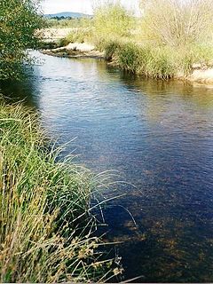
The Shoalhaven River is a perennial river that rises from the Southern Tablelands and flows into an open mature wave dominated barrier estuary near Nowra on the South Coast of New South Wales, Australia.

Tweed Heads is a town in New South Wales. It is located on the Tweed River in north-eastern New South Wales, Australia, in Tweed Shire. Tweed Heads is located next to the border with Queensland, adjacent to its "twin town" of Coolangatta, which is a suburb of the Gold Coast. It is often referred to as a town where people can change time zones – even celebrate New Year twice within an hour – simply by crossing the street, due to its proximity to the Queensland border, and the fact that New South Wales observes daylight saving whereas Queensland does not.

Coolangatta is a coastal suburb in the City of Gold Coast, Queensland, Australia. It is the Gold Coast's southernmost suburb and it borders New South Wales. In the 2016 census, Coolangatta had a population of 5,948 people.
Edward Wollstonecraft was a successful businessman in early colonial Australia, settling in what is now Sydney. He was the nephew of the early feminist Mary Wollstonecraft and cousin to Mary Wollstonecraft Shelley, the author of Frankenstein.
Miami is a coastal suburb on the Gold Coast in Queensland, Australia. Miami is located along the Gold Coast Highway, 7 kilometres (4.3 mi) south of Surfers Paradise and 17 kilometres (11 mi) north of the Queensland / New South Wales border at Coolangatta/Tweed Heads. It is part of the City of Gold Coast local government area. The town of North Burleigh is located within the suburb.

Shoalhaven Heads is a town in Shoalhaven, New South Wales, Australia. At the 2016 census, Shoalhaven Heads had a population of 3,059 people. It has a fine surfing beach, access to the Shoalhaven River and is surrounded by wineries.

Burrill Lake is a small village on the Princes Highway in the South Coast region of New South Wales, Australia. It is a seaside suburb of the Milton-Ulladulla district, a part of the City of Shoalhaven local government area and surrounds the lake of the same name. In 2016, the population Burrill Lake has a population of 1,465. The name of the town is derived from an Aboriginal word meaning 'wallaby'.
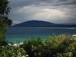
Coolangatta Mountain is a small mountain rising from the Shoalhaven River Plain in New South Wales. It rises to about 300 metres above sea level and is not open to the public. It is covered in remnant bushland and is easily visible from Saddleback Mountain. It is named after an early settlement on the banks of the Shoalhaven known as Coolangatta and is only indirectly related to the better-known Coolangatta, Queensland.
Wandandian is a small village on the South Coast of New South Wales, Australia. It is located in the City of Shoalhaven on the Princes Highway about 30 kilometres south of Nowra.
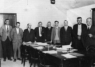
The Town of Coolangatta was a local government area in South East Queensland, Australia, centred on Coolangatta. It existed from 1914 to 1949.
Shoalhaven Coast is an Australian wine region located in the state of New South Wales.
The Queensland Football Association Northern Rivers is an Australian rules football competition containing four clubs based in the Northern Rivers region of New South Wales and the southern area of the Gold Coast in Queensland. The league was initially known as the Summerland Australian Football League and was established in 1984 as a New South Wales-only competition involving clubs from Ballina, Byron Bay, Goonellabah and Lismore. The competition saw several clubs from the regions of the Northern Rivers, New England and the Mid North Coast come and go between the 1990s and early 2000s. In 2010 the league allowed entry to its first Queensland-based team, Coolangatta-Tweed Heads. In 2012 the remaining clubs joined the AFL Queensland umbrella and rebranded to the QAFA (B) South.
Far Meadow is a locality in the City of Shoalhaven in New South Wales, Australia. It lies to the south of Coolangatta Road to the southeast of Berry. At the 2016 census, it had a population of 215.


