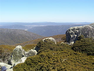
The Snowy Mountains, known informally as "The Snowies", is an IBRA subregion in southern New South Wales, Australia, and is the tallest mountain range in mainland Australia, being part of the continent's Great Dividing Range cordillera system. It makes up the northeastern half of the Australian Alps and contains Australia's five tallest peaks, all of which are above 2,100 m (6,890 ft), including the tallest Mount Kosciuszko, which reaches to a height of 2,228 m (7,310 ft) above sea level. The offshore Tasmanian highlands makes up the only other major alpine region present in the whole of Australia.

Namadgi National Park is a protected area in the south-west of the Australian Capital Territory (ACT), bordering Kosciuszko National Park in New South Wales. It lies approximately 40 kilometres (25 mi) southwest of Canberra, and occupies approximately 46 percent of the ACT's land area.
The Kosciuszko National Park is a 6,900-square-kilometre (2,700 sq mi) national park and contains mainland Australia's highest peak, Mount Kosciuszko, for which it is named, and Cabramurra, the highest town in Australia. Its borders contain a mix of rugged mountains and wilderness, characterised by an alpine climate, which makes it popular with recreational skiers and bushwalkers.

Charlotte Pass is a snow resort and village in the Snowy Mountains of New South Wales, Australia. The pass is in the Kosciuszko National Park where the Kosciuszko Road crosses Kangaroo Ridge. Charlotte Pass is the closest village to Mount Kosciuszko, the tallest mountain in Australia.

A Ramsar site is a wetland site designated to be of international importance under the Ramsar Convention, also known as "The Convention on Wetlands", an international environmental treaty signed on 2 February 1971 in Ramsar, Iran, under the auspices of UNESCO. It came into force on 21 December 1975, when it was ratified by a sufficient number of nations. It provides for national action and international cooperation regarding the conservation of wetlands, and wise sustainable use of their resources. Ramsar identifies wetlands of international importance, especially those providing waterfowl habitat.
Lake Corangamite, a hypersaline endorheic lake, is located near Colac in the Lakes and Craters region of the Victorian Volcanic Plains of south-west Victoria, Australia. The lake's salinity levels have increased dramatically as the lake level has dropped in recent decades. It is Australia's largest permanent saline lake, covering approximately 230 square kilometres (89 sq mi) with a circumference of 150 kilometres (93 mi). It forms part of the Ramsar-listed Western District Lakes wetland site. The Aboriginal name of the lake is recorded as Kronimite.
Lake Gore is a seasonal and semi-permanent freshwater lake in the Goldfields-Esperance region of Western Australia located approximately 24 km (15 mi) west of Esperance. It is an important site for waterbirds.
The Port Phillip Bay and Bellarine Peninsula Ramsar Site is one of the Australian sites listed under the Ramsar Convention as a wetland of international importance. It was designated on 15 December 1982, and is listed as Ramsar Site No.266. Much of the site is also part of either the Swan Bay and Port Phillip Bay Islands Important Bird Area or the Werribee and Avalon Important Bird Area, identified as such by BirdLife International because of their importance for wetland and waterbirds as well as for orange-bellied parrots. It comprises some six disjunct, largely coastal, areas of land, totalling 229 km2, along the western shore of Port Phillip and on the Bellarine Peninsula, in the state of Victoria. Wetland types protected include shallow marine waters, estuaries, freshwater lakes, seasonal swamps, intertidal mudflats and seagrass beds.
The Ginini Flats Wetlands Ramsar Site, also known as the Ginini Flats Subalpine Bog Complex, is a wetland in the Australian Capital Territory (ACT) that has been recognised as being of international importance by designation under the Ramsar Convention. It was listed on 11 March 1996 as Ramsar Site 793, and is the only such site in the ACT. It lies in the Australian Alps, close to the boundary of the ACT with New South Wales.

Thomsons Lake Nature Reserve is a lake nature reserve around Thomsons Lake in the City of Cockburn, Western Australia, approximately 25 kilometres (16 mi) south of the central business district of Perth, the state capital, and on the southern fringes of the Perth metropolitan area. It is in the suburb of Beeliar, 7 kilometres (4.3 mi) south-west of Jandakot Airport. It is a still largely natural wetland, with adjoining native vegetation, surrounded by land developed for housing and agriculture, that regularly supports large numbers of shorebirds and other waterbirds.

The Discovery Bay Coastal Park is a linear protected area of coastal land in western Victoria, south-eastern Australia. The 10,460-hectare (25,800-acre) park extends along the coast of Discovery Bay from Cape Nelson north-westwards for 50 kilometres (31 mi) to the border with South Australia. The park was listed on Australia's now-defunct Register of the National Estate, and lies within the traditional lands of the Gunditjmara people.

The Western District Lakes of Victoria, in the Western District of Victoria, south-eastern Australia, were recognised on 15 December 1982 as wetlands of international importance by listing under the Ramsar Convention, as Ramsar site no.268.

The Cheetham Wetlands are 420 hectares of artificial and natural lagoons, created on old salt works land on the western shores of Port Phillip Bay, Australia. The wetlands are approximately 20 kilometres (12 mi) southwest of Melbourne, and sit within the Municipal Councils of Hobsons Bay and Wyndham City.

Little Waterhouse Lake is a freshwater coastal lagoon in the Waterhouse Conservation Area of north-eastern Tasmania, Australia. In 1982 it was designated a wetland of international importance under the Ramsar Convention.
The Point Cook Coastal Park covers an area of 863 hectares and includes the Cheetham Wetlands. The park extends from the RAAF Williams Point Cook Base northeast along the coast to the Laverton creek which comprises its northern boundary. The park is approximately 20 kilometres (12 mi) from Melbourne, Australia in a southwesterly direction along Port Phillip Bay. The park is adjoined by the Point Cook Marine Sanctuary, which extends around the point to the south and the east. The northwestern boundary to the park is residential housing.

Prespa National Park is a national park situated in southeastern Albania on the border triangle shared with Greece and North Macedonia. At approximately 277.5 km2 (107.1 sq mi), the park encompasses the country's sections of the Great and Small Prespa Lake. It is considerably characterised by high mountains, narrow islands, vast freshwater wetlands, salt marshes, meadows, reed beds and dense forests.
Galaxias mungadhan, the Dargo galaxias, is a galaxiid of the genus Galaxias, a member of the Mountain Galaxias species complex group of freshwater fish, found in Victoria, Australia.
Galaxias supremus, the Kosciuszko galaxias, is a galaxiid of the genus Galaxias, a member of the Mountain Galaxias species complex group of freshwater fish, found in Australia.
Galaxias tantangara, the stocky galaxias, is a galaxiid of the genus Galaxias, a member of the Mountain Galaxias species complex group of freshwater fish, found in Australia. Only discovered in 2014, the fish is classed as critically endangered, mainly because of being preyed upon by introduced species of trout.


