Coongie Lakes

Last updated

Coongie Lakes
AustralianPelicansMcArthurRiverMouth.jpg
Up to 100,000 Australian Pelicans have been recorded at Coongie Lakes [1]
Australia South Australia relief location map.png
Red pog.svg
Coongie Lakes
Location in South Australia
Location Far North, South Australia
Coordinates 27°15′41″S140°09′25″E / 27.26139°S 140.15694°E / -27.26139; 140.15694 Coordinates: 27°15′41″S140°09′25″E / 27.26139°S 140.15694°E / -27.26139; 140.15694
Type Salt lake
Basin  countriesAustralia
Managing agency Department of Environment, Water and Natural Resources
Designation Ramsar Site [2]
Surface area21,790 km2 (8,410 sq mi) [3] :2–3
References [3] :12
Designated15 June 1987
Reference no.376 [4]

The Coongie Lakes is a freshwater wetland system located in the Far North region of South Australia. The 21,790-square-kilometre (8,410 sq mi) lakes system is located approximately 1,046 kilometres (650 miles) north of the Adelaide city centre. The wetlands includes lakes, channels, billabongs, shallow floodplains, deltas, and interdune swamps. It lies on the floodplain of Cooper Creek, an ephemeral river flowing through a desert landscape in the Lake Eyre Basin which rarely, after occasional large floods, empties into Lake Eyre. The wetland system has been recognised both as being of international importance by designation under the Ramsar Convention with a listing on 15 June 1987 and being nationally important within Australia with a listing in A Directory of Important Wetlands in Australia (DIWA). Its extent includes the regional town of Innamincka, the Malkumba-Coongie Lakes National Park, the Innamincka Regional Reserve, the Strzelecki Regional Reserve and the Coongie Lakes Important Bird Area.

Contents

Description

The Coongie Lakes is located in the north-east corner of South Australia about 1,046 kilometres (650 miles) north of the Adelaide city centre. For management purposes, the wetland system has been given a boundary which is triangular in shape. The northern apex of the triangle is near Lake Moorayepe, the south western apex is near Marion Hill in the south and the eastern apex coincides with the South Australia-Queensland border to the immediate east of the town of Innamincka. The area of land within the boundary is reported as being 21,790 square kilometres (8,410 sq mi). [3] :2–3 & 16

Land tenure is a mix of crown land, pastoral lease and protected area. The surrounding region is arid and has a very low human population density; it is used mainly for cattle grazing, as well as for oil and gas production, and is becoming increasingly important for tourism. Some of the wetlands fill only on rare occasions; some contain water for a short time after periodic flooding, while others are permanent or almost permanent. [2] It lies within the traditional lands of the Yandruwandha, Yawarrawarrka, Ngamini and Dieri people. [5]

Flora and fauna

The banks and the periodically flooded areas of Cooper Creek and Coongie Lakes wetland system are vegetated by river red gums and coolibahs, often with a dense understorey of lignum thickets. The adjacent gibber plains are sparsely covered with Mitchell grass, while the dune country has species of Dodonaea , sandhill wattle and sandhill canegrass. [5]

Major floods, generally originating in heavy rainfall in western Queensland, initiate a period of rapid, opportunistic plant growth and an influx of wildlife, especially of large numbers of waterbirds such as ducks, cormorants, pelicans, ibises, spoonbills, herons and waders that aggregate to feed and breed before dispersing as the waters recede. [2]

Mammals present in the area include red kangaroos, dingos and, in the wetlands, rakali. There are also a variety of frogs and reptiles, including the inland taipan. [5]

Protected area status

Australian government

The wetland system has recognition both internationally under the Ramsar Convention and within Australia with an identical listing in "A Directory of Important Wetlands in Australia" (DIWA). It was listed on 15 June 1987 as Ramsar site 376 while it was listed in DIWA prior to 1995. While the Ramsar convention is a treaty obligation of the Australian government, jurisdiction for the management of the wetland system lies with the South Australian government agency, the Department of Environment, Water and Natural Resources. [2] [3] :12–13 [6] [7]

South Australian government

The following protected areas proclaimed under the National Parks and Wildlife Act 1972 (SA) exist either wholly or partially within the extent of the wetland system: the Innamincka Regional Reserve, the Malkumba-Coongie Lakes National Park and the Strzelecki Regional Reserve. [3] :16

Non-statutory arrangements

Coongie Lakes Important Bird Area

An area of 593.2 square kilometres (229.0 square miles) located at the northern of the wetland system and that is specifically associated with a number of water bodies has been identified as an important bird area by Birdlife International because it supports “more than 1% of the world populations of 12 species of waterbird and shorebird” as well as “populations of the vulnerable Australian painted snipe, the near threatened blue-billed duck, the restricted-range Eyrean grasswren and five species restricted to the arid biome.” [1]

See also

Related Research Articles

Macquarie Marshes Nature Reserve Protected area in New South Wales, Australia

The Macquarie Marshes Nature Reserve is a protected natural wetland reserve that is located within the Macquarie Marshes, in the region along the lower Macquarie River in northwestern New South Wales, Australia. The 19,824-hectare (48,990-acre) reserve is situated approximately 600 kilometres (370 mi) northwest of Sydney and 100 kilometres (62 mi) north of Warren.

Lake Callabonna Lake in South Australia

Lake Callabonna is a dry salt lake with little to no vegetation located in the Far North region of South Australia. The 160-square-kilometre (62 sq mi) lake is situated approximately 120 kilometres (75 mi) southwest of Cameron Corner, the junction of South Australia, Queensland and New South Wales. It is also known as Lake Mulligan.

Strzelecki Regional Reserve is a protected area located in the Australian state of South Australia in the gazetted localities of Lindon and Strzelecki Desert about 493 kilometres north-east of Port Augusta. It includes the Strzelecki Desert and the dry Strzelecki Creek bed. The regional reserve can only accessed via the historic Strzelecki Track. It is partly located on land that was included on the List of Wetlands of International Importance under the Ramsar Convention under the name Coongie Lakes in 1987. The regional reserve is classified as an IUCN Category VI protected area.

Innamincka Regional Reserve is a protected area located in the north-east of South Australia which includes the town of Innamincka. The regional reserve was proclaimed on 22 December 1988 under National Parks and Wildlife Act 1972 over a parcel of land previously part of the Innamincka Pastoral Lease to recognise it as "a place of major conservation importance" whilst permitting ongoing mining and agricultural activity. It was the first "multiple use reserve to be administered by a nature conservation agency" to be declared in South Australia under the category of regional reserve provided for in the National Parks and Wildlife Act 1972. It is partly located on land that was included on the List of Wetlands of International Importance under the Ramsar Convention under the name Coongie Lakes in 1987. In 2005, a parcel of land was excised from the regional reserve to create the national park now known as Malkumba-Coongie Lakes National Park. It also includes the Innamincka/Cooper Creek state heritage area. The regional reserve is classified as an IUCN Category VI protected area.

Lake Warden is a salt lake in the Goldfields-Esperance region of Western Australia. It and its associated wetlands are protected in a nature reserve; they were recognised as being of international importance under the Ramsar Convention through designation of the Lake Warden System on 7 June 1990 as Ramsar Site 485. The lake is also a DIWA-listed wetland.

Vasse-Wonnerup Estuary

The Vasse-Wonnerup Estuary is an estuary in the South West region of Western Australia close to the town of Busselton. The estuary is listed with DIWA. It was also recognised as a wetland of international importance under the Ramsar Convention on 7 June 1990 when an area of 1,115 ha was designated Ramsar Site 484 as an important dry-season habitat for waterbirds. It is also the main part of the 2,038 ha (5,040-acre) Busselton Wetlands Important Bird Area.

Paroo-Darling National Park Protected area in New South Wales, Australia

The Paroo-Darling National Park is a protected national park that is located in the Far West region of New South Wales, in eastern Australia. The 178,053-hectare (439,980-acre) national park spans two distinct regions in the outback area. This region covers the arid catchments of the Paroo River and the Paroo-Darling confluence to the south.

Yanga National Park Protected area in New South Wales, Australia

The Yanga National Park is a newly formed national park, located near the township of Balranald in south- western New South Wales. It covers an area of 66,734 hectares which includes 1,932 hectares of Yanga Nature Reserve, and has a frontage of 170 kilometres (110 mi) on the Murrumbidgee River. It is largely located in the Lower Murrumbidgee Floodplain, which is included on A Directory of Important Wetlands in Australia because of its importance as a breeding site for waterbirds when flooded.

Malkumba-Coongie Lakes National Park is a protected area located in the north-east of South Australia about 110 kilometres north-west of Innamincka.

Narran Wetlands Protected area in New South Wales, Australia

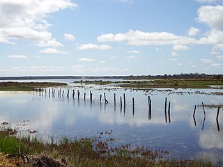
The Narran Wetlands, also known as the Narran Lakes, contained within the Narran Lake Nature Reserve, comprise a series of protected ephemeral lakes and swamps fed by the Narran River in the north-west of New South Wales, Australia. The 26,480-hectare (65,400-acre) reserve is located approximately 50 kilometres (31 mi) east of Brewarrina.

Lake Blanche is a salt lake in central South Australia that lies below sea level. It is located within the Strzelecki Creek Wetland System which is listed on A Directory of Important Wetlands in Australia. It also is within the extent of the Strzelecki Desert Lakes Important Bird Area, identified as such by BirdLife International because of its importance for waterbirds when holding water in the aftermath of floods.

Strzelecki Desert Lakes Important Bird Area Place in South Australia

The Strzelecki Desert Lakes Important Bird Area is an Important Bird Area (IBA) in the Australian state of South Australia which consists of a series of ephemeral waterbodies in the arid Strzelecki Desert in the state's Far North region. It is considered to be important for waterbirds when its constituent lakes hold water in the aftermath of floods.

Cordillo Downs

Cordillo Downs or Cordillo Downs Station is both a pastoral lease currently operating as a cattle station and a formal bounded locality in South Australia. It is located about 116 kilometres (72 mi) north of Innamincka and 155 kilometres (96 mi) south east of Birdsville. The name and boundaries of the locality were created on 26 April 2013 for the long established local name.

Lake Pinaroo

Lake Pinaroo lies in Sturt National Park in the Far West region of New South Wales, Australia. On 17 March 1996 the lake was recognised as a wetland of international importance by designation (RS799) under the Ramsar Convention.

Chowilla Regional Reserve is protected area in the Australian state of South Australia located in the gazetted locality of Chowilla about 250 kilometres (160 mi) north-east of the state capital of Adelaide.

Lake Hope is an ephemeral salt lake in the far north of South Australia.

A Regional Reserve is a type of protected area used in South Australia that allows the use of natural resources in conjunction with the protected area's conservation function. This class of protected area was first used in 1988 for the Innamincka Regional Reserve and as of 2015, there are seven regional reserves that cover an area of 93,400 square kilometres (36,062 sq mi) or 9.5% of South Australia's land area.

Strzelecki Creek

The Strzelecki Creek, part of the Lake Eyre basin, is an ephemeral watercourse located in the Australian state of South Australia.

References

  1. 1 2 "Important Bird Areas factsheet: Coongie Lakes". BirdLife International. Retrieved 28 March 2015.
  2. 1 2 3 4 "Ramsar Sites Information Service: Coongie Lakes". Ramsar Secretariat. Retrieved 28 March 2015.
  3. 1 2 3 4 5 "Information Sheet on Ramsar Wetlands: Coongie Lakes" (PDF). Department of Environment, Water and Natural Resources (DEWNR). April 2013. Retrieved 27 March 2015.
  4. "Coongie Lakes". Ramsar Sites Information Service. Retrieved 25 April 2018.
  5. 1 2 3 "Innamincka Regional Reserve and Coongie Lakes National Park" (PDF). Parks brochure. Department for Environment and Heritage, South Australia. June 2009. Retrieved 29 March 2011.
  6. Eyles, Kathy; Larmour, Geoff; Young, Sarah; Australia. Environment Australia; Natural Heritage Trust (Australia). National Wetlands Program (2001). A Directory of important wetlands in Australia (PDF) (3rd ed.). Environment Australia. pp. 1, 2 & 77. ISBN   978-0-642-54721-7.
  7. Coongie Lakes Ramsar Wetlands: A Plan for Wise Use (Draft for public consultation) (PDF). Department for Environment, Heritage and Aboriginal Affairs (DEHAA). November 1999. pp. 19–20. ISBN   0-7308-5876-6 . Retrieved 28 March 2015.