Related Research Articles
The Alpine National Park is a national park located in the Central Highlands and Alpine regions of Victoria, Australia. The 646,000-hectare (1,600,000-acre) national park is located northeast of Melbourne. It is the largest National Park in Victoria, and covers much of the higher areas of the Great Dividing Range in Victoria, including Victoria's highest point, Mount Bogong at 1,986 metres (6,516 ft) and the associated subalpine woodland and grassland of the Bogong High Plains. The park's north-eastern boundary is along the border with New South Wales, where it abuts the Kosciuszko National Park. On 7 November 2008 the Alpine National Park was added to the Australian National Heritage List as one of eleven areas constituting the Australian Alps National Parks and Reserves.
The Australian Alps montane grasslands is a montane grassland ecoregion of south-eastern Australia, restricted to the montane regions above 1300 metres .

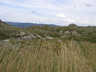
The Brindabella Range, commonly called The Brindabellas or The Brindies, is a mountain range located in Australia, on a state and territory border of New South Wales and the Australian Capital Territory (ACT). The range rises to the west of Canberra, the capital city of Australia, and includes the Namadgi National Park in the ACT and the Bimberi Nature Reserve and Brindabella National Park in New South Wales. The Brindabellas are visible to the west of Canberra and form an important part of the city's landscape.

Mer Bleue Bog is a 33.43 km2 (12.91 sq mi) protected area east of Ottawa in Eastern Ontario, Canada. Its main feature is a sphagnum bog that is situated in an ancient channel of the Ottawa River and is a remarkable boreal-like ecosystem normally not found this far south. Stunted black spruce, tamarack, bog rosemary, blueberry, and cottongrass are some of the unusual species that have adapted to the acidic waters of the bog.
The Curraghs or Ballaugh Curraghs are a wetland in Ballaugh parish in the north-west of the Isle of Man. The area has a rich and varied biodiversity and is also the location of the Curraghs Wildlife Park, a zoo and nature reserve that incorporates the wetlands.

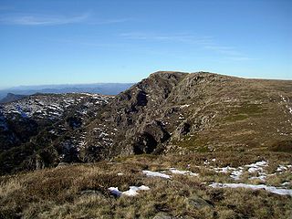
Mount Ginini is a mountain with an elevation of 1,762 metres (5,781 ft) AHD in the Brindabella Ranges that is located on the border between the Australian Capital Territory and New South Wales in Australia.

Cors Caron is a raised bog in Ceredigion, Wales. Cors is the Welsh word for "bog". Cors Caron covers an area of approximately 349 hectares. Cors Caron represents the most intact surviving example of a raised bog landscape in the United Kingdom. About 44 different species groups inhabit the area including various land and aquatic plants, fish, insects, crustaceans, lichen, fungi, terrestrial mammals and birds.

Aulacomnium palustre, the bog groove-moss or ribbed bog moss, is a moss that is nearly cosmopolitan in distribution. It occurs in North America, Hispaniola, Venezuela, Eurasia, and New Zealand. In North America, it occurs across southern arctic, subboreal, and boreal regions from Alaska and British Columbia to Greenland and Quebec. Documentation of ribbed bog moss's distribution in the contiguous United States is probably incomplete. It is reported sporadically south to Washington, Wyoming, Georgia, and Virginia.

The Blue Lake is one of only four cirque lakes found in mainland Australia. The other three, Cootapatamba, Albina, and Club, are shallower and are held entirely by terminal moraines. Blue Lake's valley contains the best-developed glacial features in the Kosciuszko National Park alpine area of New South Wales. It was recognised as a wetland of international importance on 17 March 1996 when a 320-hectare (790-acre) area, comprising the lake and its surrounds, including nearby Hedley Tarn, was designated Ramsar Site 800 under the Ramsar Convention on wetlands. The lake lies within the Australian Alps National Parks and Reserves.

The Canterbury-Otago tussock grasslands is an ecoregion of the South Island, New Zealand, part of the wider tussock grasslands of New Zealand.

The Ord River floodplain is the floodplain of the lower Ord River in the Shire of Wyndham-East Kimberley, in the Kimberley region of northern Western Australia. It lies within the Victoria Bonaparte IBRA bioregion and contains river, seasonal creek, tidal mudflat and floodplain wetlands, with extensive stands of mangroves, that support saltwater crocodiles and many waterbirds. It is recognised as an internationally important wetland area, with 1,384 square kilometres (534 sq mi) of it designated on 7 June 1990 as Ramsar Site 477 under the Ramsar Convention on Wetlands.
The Western District Lakes of Victoria, in the Western District of Victoria, south-eastern Australia, were recognised on 15 December 1982 as wetlands of international importance by listing under the Ramsar Convention, as Ramsar site no.268.

Lavinia State Reserve, formerly Lavinia Nature Reserve, is a 68 km2 protected area on King Island, lying at the western end of Bass Strait and belonging to the Australian state of Tasmania.

Logan Lagoon is a 2172 ha wetland Conservation Area on Flinders Island, the largest of the Furneaux Group at the eastern end of Bass Strait, which is part of the Australian state of Tasmania.
The Interlaken Lakeside Reserve is a wetland reserve at subalpine Interlaken, lying at the north-western end of Lake Crescent on the Interlaken isthmus between the reservoirs of Lakes Sorell and Crescent, about 20 km west of Tunbridge, in the Central Highlands of Tasmania, Australia. In 1982 it was designated a wetland of international importance under the Ramsar Convention.
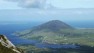
Letter Hill is a large hill near the coast to the north-west of Letterfrack in County Galway, Ireland. It is 356 m (1,168 ft) high and been listed as a Special Area of Conservation.

Situated in south-west Scotland, the Silver Flowe-Merrick Kells biosphere reserve is composed of two separate sites.

Bewick and Beanley Moors is the name given to a Site of Special Scientific Interest (SSSI) in north Northumberland, in the north-east of England. The moors are asserted to be of national importance by Natural England for the extent, quality and diversity of upland types including heaths, fens, wet grassland, flushes, mires and blanket bogs, together creating an extensive mosaic habitat supporting an exceptional community of amphibians. The moors are important, too, for their relict juniper woodland and scrub.

Garron Plateau ASSI is a 4652.18-hectare area of special scientific interest in County Antrim, Northern Ireland. Upland blanket bogs cover basalt rocks, and flushing by mineral-enriched water has resulted in the formation of alkaline fen vegetation. There are small areas of standing and running water but bogs, marshes, water fringed vegetation and fens cover 70% of the area. The remainder is heath and scrubland, humid grassland and mesophile grassland.
References
Notes
Sources
- Anon (May 2001). "Ginini Flats Wetlands Ramsar Site: Plan of Management". Conservation Series. Canberra: Environment ACT. ISSN 1036-0441.
- "The Annotated Ramsar List: Australia". The Ramsar Convention on Wetlands. 4 January 2000. Archived from the original on 19 September 2011. Retrieved 2 April 2010.