Askham Bog is small area of peat bog and Site of Special Scientific Interest situated within the Vale of York in North Yorkshire, England. It lies to the south-west of York, north of Copmanthorpe and near Askham Richard and Askham Brian.

Sphagnum is a genus of approximately 380 accepted species of mosses, commonly known as "peat moss". Accumulations of Sphagnum can store water, since both living and dead plants can hold large quantities of water inside their cells; plants may hold 16–26 times as much water as their dry weight, depending on the species. The empty cells help retain water in drier conditions. Hence, as sphagnum moss grows, it can slowly spread into drier conditions, forming larger mires, both raised bogs and blanket bogs. Thus, Sphagnum can influence the composition of such habitats, with some describing Sphagnum as 'habitat manipulators'. These peat accumulations then provide habitat for a wide array of peatland plants, including sedges and ericaceous shrubs, as well as orchids and carnivorous plants. Sphagnum and the peat formed from it do not decay readily because of the phenolic compounds embedded in the moss's cell walls. In addition, bogs, like all wetlands, develop anaerobic soil conditions, which produces slower anaerobic decay rather than aerobic microbial action. Peat moss can also acidify its surroundings by taking up cations, such as calcium and magnesium, and releasing hydrogen ions. Under the right conditions, peat can accumulate to a depth of many meters. Different species of Sphagnum have different tolerance limits for flooding and pH, so any one peatland may have a number of different Sphagnum species.

The Sweet Track is an ancient trackway, or causeway in the Somerset Levels, England, named after its finder, Ray Sweet. It was built in 3807 BC and is the second-oldest timber trackway discovered in the British Isles, dating to the Neolithic. It is now known that the Sweet Track was predominantly built over the course of an earlier structure, the Post Track.

The Mer Bleue Conservation Area is a 33.43 km2 (12.91 sq mi) protected area east of Ottawa in Eastern Ontario, Canada. Its main feature is a sphagnum bog that is situated in an ancient channel of the Ottawa River and is a remarkable boreal-like ecosystem normally not found this far south. Stunted black spruce, tamarack, bog rosemary, blueberry, and cottongrass are some of the unusual species that have adapted to the acidic waters of the bog.
Burns Bog is an ombrotrophic peat bog located in Delta, British Columbia, Canada. It is the largest raised peat bog and the largest undeveloped urban land mass on the West Coast of the Americas. Burns Bog was originally 10,000–12,000 acres (4,000–4,900 ha) before development. Currently, only 3,500 hectares remain of the bog.
Ballynahone Bog is a raised bog, situated in County Londonderry, Northern Ireland, about 3 km south of Maghera, on low-lying ground immediately north of the Moyola River about 14 km from its mouth at Lough Neagh. It is one of the largest lowland raised bogs in Northern Ireland.

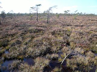
Blanket bog or blanket mire, also known as featherbed bog, is an area of peatland, forming where there is a climate of high rainfall and a low level of evapotranspiration, allowing peat to develop not only in wet hollows but over large expanses of undulating ground. The blanketing of the ground with a variable depth of peat gives the habitat type its name. Blanket bogs are found extensively throughout the northern hemisphere - well-studied examples are found in Ireland and Britain, but vast areas of the Russian and North American tundra also qualify as blanket bogs.

Westhay Moor is a 513.7-hectare (1,269-acre) biological Site of Special Scientific Interest 2.5 kilometres (1.6 mi) north-east of Westhay village and 4 kilometres (2.5 mi) from Wedmore in Somerset, England, notified in 1971. Westhay Moor is also notified as part of the Somerset Levels and Moors Special Protection Area under the EU Birds Directive and as a Ramsar Site, and a National Nature Reserve.

A palsa is a low, often oval, frost heave occurring in polar and subpolar climates, which contain permanently frozen ice lenses. Like pingos, palsas consist of an ice core with overlying soil, but they are generally smaller than pingos, often occur in groups and may develop from ground water without additional hydrostatic pressure. Palsas are characteristically found in areas with discontinuous permafrost, and in such areas they may be the only reliable surface evidence of permafrost. Surface water, found in bogs, enhances palsa formation in areas called palsa bogs.

Cors Caron is a raised bog in Ceredigion, Wales. Cors is the Welsh word for "bog": the site is also known as Tregaron Bog, being near the small town of Tregaron. Cors Caron covers an area of approximately 862 acres (349 ha). Cors Caron represents the most intact surviving example of a raised bog landscape in the United Kingdom. About 44 different species groups inhabit the area including various land and aquatic plants, fish, insects, crustaceans, lichen, fungi, terrestrial mammals and birds.
Missen are small, shallow, forest bogs in pine -dominated woods that form on crests, saddles, hollows or plateaus in the hills or mountains. They only have a thin layer of peat of between 30 and 100 centimetres thick. The term misse is local to the Northern Black Forest and also surfaces as Miß, Müsse or Müß. These names probably derive from the German Moos ("moss") because peat mosses (Sphagnum) play a key role in their development. Due to the poor tree growth associated with them, however, it could also stand for mies ("bad").
A mire is a wetland type, dominated by living, peat-forming plants. Mires arise because of incomplete decomposition of organic matter, due to waterlogging and subsequent anoxia. Like coral reefs, mires are unusual landforms in that they derive mostly from biological rather than physical processes, and can take on characteristic shapes and surface patterning.
The Red Moor is a raised bog in the Hessian part of the Rhön Mountains in Germany. It lies within the eponymous nature reserve in the Rhön Biosphere Reserve and is part of the Europe-wide conservation system, Natura 2000. The Red Moor has an area of 50 hectares and is the second largest raised bog in the High Rhön after the Black Moor (66.4 hectares). For 175 years, until 1984, peat was cut here. The interior of the raised bog is severely damaged, especially as a result of the many years of peat cutting. Its perimeters are however still largely undisturbed areas that are better and more typically developed than the Black Moor, 8 kilometres away. In 1979 large-scale renaturalisation measures began.
The Black Moor is an important internationally recognised wetland located in the Bavarian Rhön Mountains at the tripoint of the German states of Hesse, Thuringia and Bavaria. It is part of UNESCO's Rhön Biosphere Reserve and has an area of 66.4 hectares. It is thus the largest bog complex in the Rhön. Much of the moor is a largely undisturbed and intact raised bog. It is part of the Europe-wide conservation system, Natura 2000, and one of the most important raised bogs in Central Europe. The Black Moor lies on the watershed between the Rhine and Weser rivers. In 2007 the Black Moor was included in the List of the 100 most beautiful geotopes in Bavaria.
The Espy Bog is wetland complex in Columbia County, Pennsylvania, in the United States. It is situated near Bloomsburg and Espy. The wetlands contain a lake, as well as forested swamps, shrub swamps, and graminoid openings. The lake in the wetland complex may be manmade. The predominant soil in the area is known as mucky peat. The wetland complex has a high level of plant and animal biodiversity, including birds, turtles, fish, trees, shrubs, and ferns.
The Dosenmoor is a regenerative and, in places, preserved raised bog in the north German state of Schleswig-Holstein. It lies near the town of Neumünster east of the village of Einfeld and covers an area of 521 hectares. The almost circular bog lies on the watershed between the River Eider, which flows northwards, and the Stör, which flows towards the south.

The Mosbrucher Weiher, also called the Mosbrucher Maar, is a silted up maar east of the municipal boundary of the village of Mosbruch in the county Vulkaneifel in Germany. It is located immediately at the foot of the 675-metre-high Hochkelberg, a former volcano. The floor of the maar is in the shape of an elongated oval and is about 700×500 metres in size, its upper boundary has a diameter of about 1,300 × 1,050 metres. This makes the Mosbrucher Maar the third largest of the maars in the western Eifel region. The Üßbach stream flows past and close to the Mosbrucher Weiher.