Pothole (landform)

Last updated
River Orchy, Scotland, showing erosion potholes in bedrock River Orchy erosion potholes.jpg
River Orchy, Scotland, showing erosion potholes in bedrock
The hiidenkirnu pothole in Askola, Finland Hiidenkirnut 1.JPG
The hiidenkirnu pothole in Askola, Finland

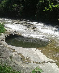
In Earth science, a pothole is a smooth, bowl-shaped or cylindrical hollow, generally deeper than wide, found carved into the rocky bed of a watercourse. Other names used for riverine potholes are pot, (stream) kettle, giant's kettle , evorsion, hollow, rock mill, churn hole, eddy mill, and kolk. [1] Although somewhat related to a pothole in origin, a plunge pool (or plunge basin or waterfall lake) is the deep depression in a stream bed at the base of a waterfall. It is created by the erosional forces of turbulence generated by water falling on rocks at a waterfall's base where the water impacts. [2] Potholes are also sometimes referred to as swirlholes. This word was created to avoid confusion with an English term for a vertical or steeply inclined karstic shaft in limestone. However, given widespread usage of this term for a type of fluvial sculpted bedrock landform, pothole is preferred in usage to swirlhole. [3]

The "pot that washes itself" located just south of the village of Canajoharie ThePotThatWashesItself.jpg
The "pot that washes itself" located just south of the village of Canajoharie

The term pothole is also used to refer to other types of depressions and basins that differ in origin. [1] For example, some authors [4] [5] refer to panholes found in the Colorado Plateau also as potholes. Other terms used for panholes are gnamma (Australia), opferkessel (German, roughly “sacrificial basin”), armchair hollows, weathering pans (or pits) and solution pans or solution pits. [6] In another case, the term pothole is used to refer to a shallow depression, generally less than 10-acre (4.0 ha) in area that occurs between dunes or on subdued morainic relief on a prairie, as in Minnesota and the Dakotas, and often contains an intermittent pond or marsh that serves as a nesting place for waterfowl. [1]

Origin

The consensus of geomorphologists and sedimentologists is that fluvial potholes are created by the grinding action of either a stone or stones or coarse sediment (sand, gravel, pebbles, boulders), whirled around and kept in motion by eddies within and force of the stream current in a given spot. Being a spectacular feature of bedrock river channels, they have been and still are studied extensively and considered as a key factor in bedrock channel development and morphology and important factor in the incision of bedrock channels. [3] [7] [8]

Related Research Articles

<span class="mw-page-title-main">Fluvial processes</span> Processes associated with rivers and streams

In geography and geology, fluvial processes are associated with rivers and streams and the deposits and landforms created by them. When the stream or rivers are associated with glaciers, ice sheets, or ice caps, the term "glaciofluvial" or "fluvioglacial" is used.

Landforms are categorized by characteristic physical attributes such as their creating process, shape, elevation, slope, orientation, rock exposure, and soil type.

<span class="mw-page-title-main">Body of water</span> Any significant accumulation of water, generally on a planets surface

A body of water or waterbody is any significant accumulation of water on the surface of Earth or another planet. The term most often refers to oceans, seas, and lakes, but it includes smaller pools of water such as ponds, wetlands, or more rarely, puddles. A body of water does not have to be still or contained; rivers, streams, canals, and other geographical features where water moves from one place to another are also considered bodies of water.

<span class="mw-page-title-main">Channeled Scablands</span> Landscape in eastern Washington state scoured by cataclysmic floods during the Pleistocene epoch

The Channeled Scablands are a relatively barren and soil-free region of interconnected relict and dry flood channels, coulees and cataracts eroded into Palouse loess and the typically flat-lying basalt flows that remain after cataclysmic floods within the southeastern part of Washington state. The Channeled Scablands were scoured by more than 40 cataclysmic floods during the Last Glacial Maximum and innumerable older cataclysmic floods over the last two million years. These floods were periodically unleashed whenever a large glacial lake broke through its ice dam and swept across eastern Washington and down the Columbia River Plateau during the Pleistocene epoch. The last of the cataclysmic floods occurred between 18,200 and 14,000 years ago.

<span class="mw-page-title-main">Depression (geology)</span> Landform sunken or depressed below the surrounding area

In geology, a depression is a landform sunken or depressed below the surrounding area. Depressions form by various mechanisms.

<span class="mw-page-title-main">Giant's kettle</span> Hole drilled in the rock by Eddy currents of water bearing gravel

A giant's kettle, also known as either a giant's cauldron, moulin pothole, or glacial pothole, is a typically large and cylindrical pothole drilled in solid rock underlying a glacier either by water descending down a deep moulin or by gravel rotating in the bed of subglacial meltwater stream.

<span class="mw-page-title-main">Meander</span> One of a series of curves in a channel of a matured stream

A meander is one of a series of regular sinuous curves in the channel of a river or other watercourse. It is produced as a watercourse erodes the sediments of an outer, concave bank and deposits sediments on an inner, convex bank which is typically a point bar. The result of this coupled erosion and sedimentation is the formation of a sinuous course as the channel migrates back and forth across the axis of a floodplain.

<span class="mw-page-title-main">Knickpoint</span> Point on a streams profile where a sudden change in stream gradient occurs

In geomorphology, a knickpoint or nickpoint is part of a river or channel where there is a sharp change in channel slope, such as a waterfall or lake. Knickpoints reflect different conditions and processes on the river, often caused by previous erosion due to glaciation or variance in lithology. In the cycle of erosion model, knickpoints advance one cycle upstream, or inland, replacing an older cycle. A knickpoint that occurs at the head of a channel is called a headcut. Headcuts resulting in headward erosion are hallmarks of unstable expanding drainage features such as actively eroding gullies.

<span class="mw-page-title-main">Plunge pool</span> Depression at the base of a waterfall

A plunge pool is a deep depression in a stream bed at the base of a waterfall or shut-in. It is created by the erosional forces of cascading water on the rocks at formation's base where the water impacts. The term may refer to the water occupying the depression, or the depression itself.

<span class="mw-page-title-main">Abrasion (geology)</span>

Abrasion is a process of erosion which occurs when material being transported wears away at a surface over time. It is the process of friction caused by scuffing, scratching, wearing down, marring, and rubbing away of materials. The intensity of abrasion depends on the hardness, concentration, velocity and mass of the moving particles. Abrasion generally occurs in four ways: glaciation slowly grinds rocks picked up by ice against rock surfaces; solid objects transported in river channels make abrasive surface contact with the bed and walls; objects transported in waves breaking on coastlines; and by wind transporting sand or small stones against surface rocks.

A rock-cut basin is a natural cylindrical depression cut into stream or river beds, often filled with water. Such plucked-bedrock pits are created by kolks; powerful vortices within the water currents which spin small boulders around, eroding out these rock basins by their abrasive action. These basins are frequently found in streams and rivers with a relatively soft rock substrates such as limestones and sandstones. The rather unusual and man-made appearance of such depressions has led to various folk-tales becoming associated with them, such as their identification as petrosomatoglyphs, including knee prints, elbow prints, etc. of saints, heroes, kings or supernatural beings.

<span class="mw-page-title-main">Drop structure</span> Structure that lowers elevation of water in a controlled fashion

A drop structure, also known as a grade control, sill, or weir, is a manmade structure, typically small and built on minor streams, or as part of a dam's spillway, to pass water to a lower elevation while controlling the energy and velocity of the water as it passes over. Unlike most dams, drop structures are usually not built for water impoundment, diversion or raising the water level. Mostly built on watercourses with steep gradients, they serve other purposes such as water oxygenation and erosion prevention.

<span class="mw-page-title-main">Drainage system (geomorphology)</span> Patterns formed by streams, rivers, and lakes in a drainage system

In geomorphology, drainage systems, also known as river systems, are the patterns formed by the streams, rivers, and lakes in a particular drainage basin. They are governed by the topography of land, whether a particular region is dominated by hard or soft rocks, and the gradient of the land. Geomorphologists and hydrologists often view streams as part of drainage basins. This is the topographic region from which a stream receives runoff, throughflow, and its saturated equivalent, groundwater flow. The number, size, and shape of the drainage basins varies and the larger and more detailed the topographic map, the more information is available.

<span class="mw-page-title-main">River</span> Natural flowing watercourse

A river is a natural flowing watercourse, usually a freshwater stream, flowing on the surface or inside caves towards another waterbody at a lower elevation, such as an ocean, sea, bay, lake, wetland, or another river. In some cases, a river flows into the ground or becomes dry at the end of its course without reaching another body of water. Small rivers can be referred to by names such as creek, brook, and rivulet. There are no official definitions for the generic term river as applied to geographic features, although in some countries or communities, a stream is defined by its size. Many names for small rivers are specific to geographic location; examples are "run" in some parts of the United States, "burn" in Scotland and Northeast England, and "beck" in Northern England. Sometimes a river is defined as being larger than a creek, but not always; the language is vague.

<span class="mw-page-title-main">Panhole</span> Depression or basin eroded into flat or gently sloping cohesive rock

A panhole is a depression or basin eroded into flat or gently sloping cohesive rock. Similar terms for this feature are gnamma or rock holes (Australia), armchair hollows, weathering pans and solution pans.

A pothole is a surface disruption in a roadway, caused by fatigue and erosion.

Keelung Nuannuan pothole is a pothole or kettle hole in the exposed bed of the Keelung River at Nuannuan District, Keelung City in Taiwan. A pothole is a circular depression on the river bed carved out of solid rock. It is formed by a kind of drilling action as pebbles are caught in eddy currents and whisked around within a small natural crack or hollow. As time passes, the drilling action enlarges the hollow to form a pothole. Potholes are commonly found below waterfalls or rapids where hydraulic action is a significant process.

A pendant bar is a large, streamlined, fluvial bar that is typically composed of gravel which occurs just downstream of a bedrock obstruction within a river channel or floodway that has been scoured by either an outburst flood, megaflood, or jökulhlaup. They are often associated with giant current ripples. Malde introduced this to refer to streamlined mounds of gravel deposited by the Bonneville Flood that lie downstream of bedrock projections on the scoured valley floor of the Snake River. They are most common type of bar found within the Channeled Scablands created by the Missoula floods. The obstruction for the initiation of pendant bars in the Channeled Scablands is typically either a knob of basalt or the relict bend of a pre-flood meandering valley.

<span class="mw-page-title-main">River incision</span>

River incision is the narrow erosion caused by a river or stream that is far from its base level. River incision is common after tectonic uplift of the landscape. Incision by multiple rivers result in a dissected landscape, for example a dissected plateau. River incision is the natural process by which a river cuts downward into its bed, deepening the active channel. Though it is a natural process, it can be accelerated rapidly by human factors including land use changes such as timber harvest, mining, agriculture, and road and dam construction. The rate of incision is a function of basal shear-stress. Shear stress is increased by factors such as sediment in the water, which increase its density. Shear stress is proportional to water mass, gravity, and WSS:

<span class="mw-page-title-main">Glaciofluvial deposits</span> Sediments/deposits formed from ice sheets or glaciers

Glaciofluvial deposits or Glacio-fluvial sediments consist of boulders, gravel, sand, silt and clay from ice sheets or glaciers. They are transported, sorted and deposited by streams of water. The deposits are formed beside, below or downstream from the ice. They include kames, kame terraces and eskers formed in ice contact and outwash fans and outwash plains below the ice margin. Typically the outwash sediment is carried by fast and turbulent fluvio-glacial meltwater streams, but occasionally it is carried by catastrophic outburst floods. Larger elements such as boulders and gravel are deposited nearer to the ice margin, while finer elements are carried farther, sometimes into lakes or the ocean. The sediments are sorted by fluvial processes. They differ from glacial till, which is moved and deposited by the ice of the glacier, and is unsorted.

References

  1. 1 2 3 Neuendorf, K.K.E., J.P. Mehl, Jr., and J.A. Jackson, eds., 2011. Glossary of Geology (5th ed.). Alexandria, Virginia, American Geological Institute. 800 pp. ISBN   0-922152-89-6
  2. Marshak, Stephen, 2009. Essentials of Geology, W. W. Norton & Company, 3rd ed. ISBN   978-0393196566
  3. 1 2 Richardson, K. and Carling, P., 2005. A typology of sculpted forms in open bedrock channels.Special Paper 392. Boulder, Colorado: Geological Society of America. 108 pp. ISBN   0-813723-92-2
  4. Chan, M.A., Moser, K., Davis, J.M., Southam, G., Hughes, K. and Graham, T., 2005. Desert potholes: ephemeral aquatic microsystems.Aquatic Geochemistry, 11(3), pp. 279-302.
  5. Hughes, Kebbi A., 2012. Bacterial Communities and their Influence on the Formation and Development of Potholes in Sandstone Surfaces of the Semi-Arid Colorado Plateau University of Western Ontario - Electronic Thesis and Dissertation Repository. Paper 543.
  6. Twidale, C.R., and Bourne, J.A., 2018. Rock basins (gnammas) revisited. Géomorphologie: Relief, Processus, Environnement, Articles sous presse, Varia, mis en ligne le 08 janvier 2018, consulté le 01 juillet 2018.
  7. Das, B.C., 2018. Development of Streambed Potholes and the Role of Grinding Stones.Journal of Environmental Geography. 11 (1–2), 9–16.
  8. Whipple, K.X., Hancock, G.S., and Anderson, R.S., 2000. River Incision Into Bedrock: Mechanics And Relative Efficacy Of Plucking, Abrasion And Cavitation.Geological Society Of America Bulletin. 112, 490–503.