
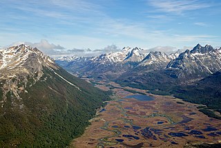
In physical geography, tundra is a type of biome where the tree growth is hindered by frigid temperatures and short growing seasons. The term tundra comes through Russian тундра from the Kildin Sámi word тӯндар meaning "uplands", "treeless mountain tract". There are three regions and associated types of tundra: Arctic tundra, alpine tundra, and Antarctic tundra.

A swamp is a forested wetland. Swamps are considered to be transition zones because both land and water play a role in creating this environment. Swamps vary in size and are located all around the world. The water of a swamp may be fresh water, brackish water, or seawater. Freshwater swamps form along large rivers or lakes where they are critically dependent upon rainwater and seasonal flooding to maintain natural water level fluctuations. Saltwater swamps are found along tropical and subtropical coastlines. Some swamps have hammocks, or dry-land protrusions, covered by aquatic vegetation, or vegetation that tolerates periodic inundation or soil saturation. The two main types of swamp are "true" or swamp forests and "transitional" or shrub swamps. In the boreal regions of Canada, the word swamp is colloquially used for what is more formally termed a bog, fen, or muskeg. Some of the world's largest swamps are found along major rivers such as the Amazon, the Mississippi, and the Congo.

A wetland is a distinct ecosystem that is flooded by water, either permanently or seasonally. Flooding results in oxygen-free (anoxic) processes prevailing, especially in the soils. The primary factor that distinguishes wetlands from terrestrial land forms or water bodies is the characteristic vegetation of aquatic plants, adapted to the unique anoxic hydric soils. Wetlands are considered among the most biologically diverse of all ecosystems, serving as home to a wide range of plant and animal species. Methods for assessing wetland functions, wetland ecological health, and general wetland condition have been developed for many regions of the world. These methods have contributed to wetland conservation partly by raising public awareness of the functions some wetlands provide.

A fen is a type of peat-accumulating wetland fed by mineral-rich ground or surface water. It is one of the main types of wetlands along with marshes, swamps, and bogs. Bogs and fens, both peat-forming ecosystems, are also known as mires. The unique water chemistry of fens is a result of the ground or surface water input. Typically, this input results in higher mineral concentrations and a more basic pH than found in bogs. As peat accumulates in a fen, groundwater input can be reduced or cut off, making the fen ombrotrophic rather than minerotrophic. In this way, fens can become more acidic and transition to bogs over time.

A bog or bogland is a wetland that accumulates peat as a deposit of dead plant materials – often mosses, typically sphagnum moss. It is one of the four main types of wetlands. Other names for bogs include mire, mosses, quagmire, and muskeg; alkaline mires are called fens. A baygall is another type of bog found in the forest of the Gulf Coast states in the United States. They are often covered in heath or heather shrubs rooted in the sphagnum moss and peat. The gradual accumulation of decayed plant material in a bog functions as a carbon sink.
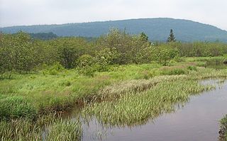
A marsh is a wetland that is dominated by herbaceous rather than woody plant species. Marshes can often be found at the edges of lakes and streams, where they form a transition between the aquatic and terrestrial ecosystems. They are often dominated by grasses, rushes or reeds. If woody plants are present they tend to be low-growing shrubs, and then sometimes called carrs. This form of vegetation is what differentiates marshes from other types of wetland such as swamps, which are dominated by trees, and mires, which are wetlands that have accumulated deposits of acidic peat.
Pottageville is an unincorporated community located in northeastern King Township, in Ontario, Canada. It is near Schomberg. It is named for one of its early settlers, Edward Pottage.

A reedbed or reed bed is a natural habitat found in floodplains, waterlogged depressions and estuaries. Reedbeds are part of a succession from young reeds colonising open water or wet ground through a gradation of increasingly dry ground. As reedbeds age, they build up a considerable litter layer that eventually rises above the water level and that ultimately provides opportunities for shrubland or woodland invasion.

A hydrosere is a plant succession which occurs in an area of fresh water such as in oxbow lakes and kettle lakes. In time, an area of open freshwater will naturally dry out, ultimately becoming woodland. During this change, a range of different landtypes such as swamp and marsh will succeed each other.

Palustrine wetlands include any inland wetland that contains ocean-derived salts in concentrations of less than 0.5 parts per thousand, and is non-tidal. The word palustrine comes from the Latin word palus or marsh. Wetlands within this category include inland marshes and swamps as well as bogs, fens, pocosins, tundra and floodplains.

Before drainage, the Everglades, a region of tropical wetlands in southern Florida, were an interwoven mesh of marshes and prairies covering 4,000 square miles (10,000 km2). The Everglades is both a vast watershed that has historically extended from Lake Okeechobee 100 miles (160 km) south to Florida Bay, and many interconnected ecosystems within a geographic boundary. It is such a unique meeting of water, land, and climate that the use of either singular or plural to refer to the Everglades is appropriate. When Marjory Stoneman Douglas wrote her definitive description of the region in 1947, she used the metaphor "River of Grass" to explain the blending of water and plant life.
The Prehistoric Park is an Italian naturalistic park of more than 100 hectares of wood, situated on the outskirts of the Rivolta d'Adda commune, Cremona province, about 20 kilometers east of Milan. The park is adjacent to the homonym Adda river and contains 30 reconstructions of prehistoric animals, a hundred semi-liberty wild animals, a botanical itinerary with plants signalled, natural environments, picnic reggeds areas, a café, playing parks, a labyrinth, and shows of fossils, etc., all along a shaded course. The access to the park is exclusively pedestrian, but access is allowed to bicycles and dogs with leashes. The park is also recognized by various national and local corporate bodies that testify to the validity of the structure as a guide to the environmental education, not only to children, but of adults as well.
Classification of wetlands has been a problematical task, with the commonly accepted definition of what constitutes a wetland being among the major difficulties. A number of national wetland classifications exist. In the 1970s, the Ramsar Convention on Wetlands of International Importance introduced a first attempt to establish an internationally acceptable wetland classification scheme.
Shrub swamps — also called scrub swamps or buttonbush swamps — are a type of freshwater wetland ecosystem occurring in areas too wet to become swamps, but too dry or too shallow to become marshes. They are often considered transitional (“mid-successional”) between wet meadows or fens and conifer or hardwood swamps.
The Biebrza Marshes are a wetland complex, located on the Biebrza river valley, in Suwałki, Łomża in the northeast of Poland. The area encompasses river channels, lakes, extensive marshes with wooded areas on higher ground, such as alder carrs, and well-preserved peat bogs that occupy around 1,000 km2. The area shows a clear succession of habitats from riverside fen through to raised bogs, grading into wet woodland. Because of this unique succession, the area supports a wide diversity of wildlife with large numbers of birds and mammals. Over 250 species of birds have been recorded including more than 80% of the Polish avifauna. Starting in the early spring mating birds attract birdwatchers from around the world.
A mire, peatland, or quagmire is a wetland area dominated by living peat-forming plants. Mires arise because of incomplete decomposition of organic matter, usually litter from vegetation, due to water-logging and subsequent anoxia. All types of mires share the common characteristic of being saturated with water, at least seasonally with actively forming peat, while having their own ecosystem. Like coral reefs, mires are unusual landforms that derive mostly from biological rather than physical processes, and can take on characteristic shapes and surface patterning.

The Havelland Luch is a lowland area inside a bend of the River Havel west of Berlin, and forms the heart of the Havelland region.
An alder carr is a particular type of carr, i.e. waterlogged wooded terrain populated with alder trees.

Cow Myers is a Site of Special Scientific Interest (SSSI) located in the Nidderdale Area of Outstanding Natural Beauty (AONB), near Ripon, North Yorkshire, England. The site was designated in 1984 for its fen and alder carr habitat, which supports a diversity of wetland plant life. Of particular interest are the bird's eye primrose which is scarce in Yorkshire, and early marsh orchid. There is no public access to this site, no vehicular access, and no public facilities.

Mar Field Fen is a Site of Special Scientific Interest, or SSSI, north of Masham, North Yorkshire, England, in a rural area known as Marfield. It is situated on land containing woodland carr, fen, spring-fed marshy grassland and drier calcareous grassland, between the River Ure to the east and Marfield Wetland nature reserve to the west. As "one of the best examples of fen habitat in the Vale of York," it is a protected habitat for a variety of plants, including the common butterwort, a carnivorous plant. There is no public access to this site.
