
Paludification is the most common process by which peatlands in the boreal zone are formed.
Paludification is the most common process by which peatlands in the boreal zone are formed.
The process is characterized by peat initialization on previously drier and vegetated habitats over inorganic soils, with no fully aquatic phase. [1] Thus the paludification process includes a shift from forests, grassland or long exposed bare land to peatland. [2] The initiation of this accumulation of organic matter (i.e. peat), can be controlled by both allogenic (i.e. external to the ecosystem) and autogenic (i.e. internal to the ecosystem) factors. [3] The hydrological balance is critical for the initiation of peat. The hydrological balance can simply be defined as the difference between the incoming and outgoing amount of water (e.g. precipitation minus evapotranspiration and minus runoff). Usually it is considered that factors such as climate, geomorphology, geology and soils control this balance. However, paludification may also be just a result of the local accumulation of peat (i.e. autogenic factor). [4]
The climate factor has a great influence on the paludification process. The development of a paludified soil requires a positive hydrological balance during the growing season. Therefore, there needs to be a shift in local hydrological conditions. Such a shift could be caused by an increase in water inputs or a decrease in outputs. Human activity such as tree removal, natural or human induced forest fires, increase in precipitation, and podsolization, etc. are processes which could change those in- and outputs. [5]
The factor geomorphology (and also topography) creates spatial diversity in the hydrological characteristics of the landscape. The flat topography (and thus low slopes) in the two major peatlands in the world, located in the West Siberian Plain and in the Hudson/James Bay Lowlands of Canada respectively, illustrate the significance of this factor. [6]
Geology and soils (i.e. bedrock and texture) play also an important role. When the mineral soil is composed of heavy clay, the soil will act as an impermeable substrate that facilitates water accumulation. [7]
Simply an increase in surface water from melting permafrost can cause increased paludification in boreal ecosystems. [8] [9]
In the context of forest management, paludification has been studied intensively during the last decade. Especially because of the negative effects paludification has for the boreal forests. In this way that paludification may lead to:

A swamp is a forested wetland. Swamps are considered to be transition zones because both land and water play a role in creating this environment. Swamps vary in size and are located all around the world. The water of a swamp may be fresh water, brackish water, or seawater. Freshwater swamps form along large rivers or lakes where they are critically dependent upon rainwater and seasonal flooding to maintain natural water level fluctuations. Saltwater swamps are found along tropical and subtropical coastlines. Some swamps have hammocks, or dry-land protrusions, covered by aquatic vegetation, or vegetation that tolerates periodic inundation or soil saturation. The two main types of swamp are "true" or swamp forests and "transitional" or shrub swamps. In the boreal regions of Canada, the word swamp is colloquially used for what is more correctly termed a bog, fen, or muskeg. Some of the world's largest swamps are found along major rivers such as the Amazon, the Mississippi, and the Congo.
Peat, sometimes known as turf, is an accumulation of partially decayed vegetation or organic matter. It is unique to natural areas called peatlands, bogs, mires, moors, or muskegs. The peatland ecosystem covers 3.7 million square kilometres and is the most efficient carbon sink on the planet, because peatland plants capture CO2 naturally released from the peat, maintaining an equilibrium. In natural peatlands, the "annual rate of biomass production is greater than the rate of decomposition", but it takes "thousands of years for peatlands to develop the deposits of 1.5 to 2.3 m [4.9 to 7.5 ft], which is the average depth of the boreal [northern] peatlands", which store around 415 gigatonnes of carbon (about 46 times 2019 global CO2 emissions). Globally, it even stores up to 550 gigatonnes of carbon, representing 42% of all soil carbon and exceeds the carbon stored in all other vegetation types, including the world's forests. Across the world, peat covers just 3% of the land’s surface, but stores one-third of the Earth’s soil carbon. Sphagnum moss, also called peat moss, is one of the most common components in peat, although many other plants can contribute. The biological features of sphagnum mosses act to create a habitat aiding peat formation, a phenomenon termed 'habitat manipulation'. Soils consisting primarily of peat are known as histosols. Peat forms in wetland conditions, where flooding or stagnant water obstructs the flow of oxygen from the atmosphere, slowing the rate of decomposition.

A wetland is a distinct ecosystem that is flooded by water, either permanently or seasonally, where oxygen-free processes prevail. The primary factor that distinguishes wetlands from other land forms or water bodies is the characteristic vegetation of aquatic plants, adapted to the unique hydric soil. Wetlands play a number of functions, including water purification, water storage, processing of carbon and other nutrients, stabilization of shorelines, and support of plants and animals. Wetlands are also considered the most biologically diverse of all ecosystems, serving as home to a wide range of plant and animal life. Whether any individual wetland performs these functions, and the degree to which it performs them, depends on characteristics of that wetland and the lands and waters near it. Methods for rapidly assessing these functions, wetland ecological health, and general wetland condition have been developed in many regions and have contributed to wetland conservation partly by raising public awareness of the functions and the ecosystem services some wetlands provide.

A fen is one of the main types of wetlands, the others being grassy marshes, forested swamps, and peaty bogs. Along with bogs, fens are a kind of mire. Fens are minerotrophic peatlands, usually fed by mineral-rich surface water or groundwater. They are characterized by their distinct water chemistry, which is pH neutral or alkaline, with relatively high dissolved mineral levels but few other plant nutrients. Continuous input of groundwater into fens maintains a stable water table throughout the course of a year. The stable water table helps maintain multiple defining characteristics of fens, namely the neutral pH, high base saturation, and low nutrient availability. They are usually dominated by grasses and sedges, and typically have brown mosses. Fens frequently have a high diversity of other plant species including carnivorous plants such as Pinguicula. They may also occur along large lakes and rivers where seasonal changes in water level maintain wet soils with few woody plants. The distribution of individual species of fen plants is often closely connected to water regimes and nutrient concentrations.

A bog or bogland is a wetland that accumulates peat, a deposit of dead plant material—often mosses, and in a majority of cases, sphagnum moss. It is one of the four main types of wetlands. Other names for bogs include mire, mosses, quagmire, and muskeg; alkaline mires are called fens. A baygall is another type of bog found in the forest of the Gulf Coast states in the USA. They are often covered in heath or heather shrubs rooted in the sphagnum moss and peat. The gradual accumulation of decayed plant material in a bog functions as a carbon sink.

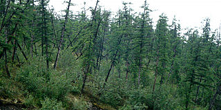
Picea mariana, the black spruce, is a North American species of spruce tree in the pine family. It is widespread across Canada, found in all 10 provinces and all 3 Arctic territories. Its range extends into northern parts of the United States: in Alaska, the Great Lakes region, and the upper Northeast. It is a frequent part of the biome known as taiga or boreal forest.

The Bog of Allen is a large raised bog in the centre of Ireland between the rivers Liffey and Shannon.

Mer Bleue Bog is a 33.43 km2 (12.91 sq mi) protected area east of Ottawa in Eastern Ontario, Canada. Its main feature is a sphagnum bog that is situated in an ancient channel of the Ottawa River and is a remarkable boreal-like ecosystem normally not found this far south. Stunted black spruce, tamarack, bog rosemary, blueberry, and cottongrass are some of the unusual species that have adapted to the acidic waters of the bog.

Peat swamp forests are tropical moist forests where waterlogged soil prevents dead leaves and wood from fully decomposing. Over time, this creates a thick layer of acidic peat. Large areas of these forests are being logged at high rates.
Drunken trees, tilted trees, or a drunken forest, is a stand of trees displaced from their normal vertical alignment.

Tropical peat is a type of histosol that found in tropical latitude, including South East Asia, Africa, and Central and South America. Tropical peat mostly consists of dead organic matter from trees instead of spaghnum which are commonly found in temperate peat. This soil usually contain high organic matter content, exceeding 75% with dry low bulk density around 0.2 mg/m3 (0.0 gr/cu ft).

Aulacomnium palustre, the bog groove-moss or ribbed bog moss, is a moss that is nearly cosmopolitan in distribution. It occurs in North America, Hispaniola, Venezuela, Eurasia, and New Zealand. In North America, it occurs across southern arctic, subboreal, and boreal regions from Alaska and British Columbia to Greenland and Quebec. Documentation of ribbed bog moss's distribution in the contiguous United States is probably incomplete. It is reported sporadically south to Washington, Wyoming, Georgia, and Virginia.

Climate change in Russia is the changes in Russia's climate due to human caused global warming. This causes several effects, such as permafrost melting and more wildfires. Adaptation to climate change is difficult.

Raised bogs, also called ombrotrophic bogs, are acidic, wet habitats that are poor in mineral salts and are home to flora and fauna that can cope with such extreme conditions. Raised bogs, unlike fens, are exclusively fed by precipitation (ombrotrophy) and from mineral salts introduced from the air. They thus represent a special type of bog, hydrologically, ecologically and in terms of their development history, in which the growth of peat mosses over centuries or millennia plays a decisive role. They also differ in character from blanket bogs which are much thinner and occur in wetter, cloudier climatic zones.

Sabangau National Park is a national park in Central Kalimantan, a province of Indonesia in Kalimantan, the Indonesian part of the island of Borneo established in 2004. Between 1980 and 1995 the site was a massive logging concessions area. After 1995, the park became a site for illegal logging, which resulted in up to 85 percent of the 568,700-hectare total park area being destroyed. By 2012, less than 1 percent of the park's total area has been reforested and several centuries is needed to restore it to its pre-logged state.

Climate change feedback is important in the understanding of global warming because feedback processes may amplify or diminish the effect of each climate forcing, and so play an important part in determining the climate sensitivity and future climate state. Feedback in general is the process in which changing one quantity changes a second quantity, and the change in the second quantity in turn changes the first. Positive feedback amplifies the change in the first quantity while negative feedback reduces it.

The permafrost carbon cycle is a sub-cycle of the larger global carbon cycle. Permafrost is defined as subsurface material that remains below 0o C for at least two consecutive years. Because permafrost soils remain frozen for long periods of time, they store large amounts of carbon and other nutrients within their frozen framework during that time. Permafrost represents a large carbon reservoir that is seldom considered when determining global terrestrial carbon reservoirs. Recent and ongoing scientific research however, is changing this view.
A mire, peatland or quagmire is a wetland type, dominated by living peat-forming plants. Mires arise because of incomplete decomposition of organic matter, usually litter from vegetation, due to water-logging and subsequent anoxia. All types of mires share the common characteristic of being saturated with water at least seasonally with actively forming peat, while having its own set of vegetation and organisms. Like coral reefs, mires are unusual landforms in that they derive mostly from biological rather than physical processes, and can take on characteristic shapes and surface patterning.
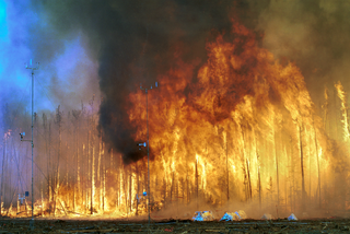
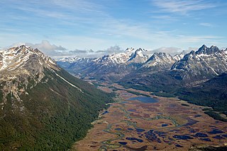
Terrestrial ecosystems found in the boreal regions of North America and Eurasia cover less than 17% of the earth's land surface, yet contain more than 30% of all carbon present in the terrestrial biome. In terms of carbon storage, the boreal region consists of three ecosystems: boreal forest, peatland, and tundra. Vast areas of the globe and are contributing greatly to atmospheric carbon release due to increased temperature and fire hazard. High northern latitudes will experience the most significant increase in warming on the planet as a result of increased atmospheric greenhouse gases thus placing in jeopardy the carbon sink in these areas. In addition to the release of carbon through the melting of permafrost, high intensity wildfires will become more common and thus contribute to the release of stored carbon. This means that the boreal forest and its fire regime is becoming an increasingly more significant factor in determining the global carbon budget.
Dale Hadley Vitt is an American bryologist and peatland ecologist, recognized as a leading expert on peatlands. From 1989 to 1991 he was the president of the American Bryological and Lichenological Society.