
A biome is a distinct geographical region with specific climate, vegetation, and animal life. It consists of a biological community that has formed in response to its physical environment and regional climate. Biomes may span more than one continent. A biome encompasses multiple ecosystems within its boundaries. It can also comprise a variety of habitats.

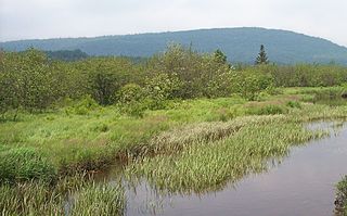
A swamp is a forested wetland. Swamps are considered to be transition zones because both land and water play a role in creating this environment. Swamps vary in size and are located all around the world. The water of a swamp may be fresh water, brackish water, or seawater. Freshwater swamps form along large rivers or lakes where they are critically dependent upon rainwater and seasonal flooding to maintain natural water level fluctuations. Saltwater swamps are found along tropical and subtropical coastlines. Some swamps have hammocks, or dry-land protrusions, covered by aquatic vegetation, or vegetation that tolerates periodic inundation or soil saturation. The two main types of swamp are "true" or swamp forests and "transitional" or shrub swamps. In the boreal regions of Canada, the word swamp is colloquially used for what is more formally termed a bog, fen, or muskeg. Some of the world's largest swamps are found along major rivers such as the Amazon, the Mississippi, and the Congo.

A wetland is a distinct semi-aquatic ecosystem whose groundcovers are flooded or saturated in water, either permanently, for years or decades, or only seasonally. Flooding results in oxygen-poor (anoxic) processes taking place, especially in the soils. Wetlands form a transitional zone between waterbodies and dry lands, and are different from other terrestrial or aquatic ecosystems due to their vegetation's roots having adapted to oxygen-poor waterlogged soils. They are considered among the most biologically diverse of all ecosystems, serving as habitats to a wide range of aquatic and semi-aquatic plants and animals, with often improved water quality due to plant removal of excess nutrients such as nitrates and phosphorus.

Limnology is the study of inland aquatic ecosystems. The study of limnology includes aspects of the biological, chemical, physical, and geological characteristics of fresh and saline, natural and man-made bodies of water. This includes the study of lakes, reservoirs, ponds, rivers, springs, streams, wetlands, and groundwater. Water systems are often categorized as either running (lotic) or standing (lentic).

Aquatic plants are vascular plants that have adapted to live in aquatic environments. They are also referred to as hydrophytes or macrophytes to distinguish them from algae and other microphytes (phytoplanktons). In lakes, rivers and wetlands, aquatic vegetations provide cover for aquatic animals such as fish, amphibians and aquatic insects, create substrate for benthic invertebrates, produce oxygen via photosynthesis, and serve as food for some herbivorous wildlife. Familiar examples of aquatic plants include waterlily, lotus, duckweeds, mosquito fern, floating heart, water milfoils, mare's tail, water lettuce and water hyacinth.

In ecology, a marsh is a wetland that is dominated by herbaceous plants rather than by woody plants. More in general, the word can be used for any low-lying and seasonally waterlogged terrain. In Europe and in agricultural literature low-lying meadows that require draining and embanked polderlands are also referred to as marshes or marshland.
Freshwater ecosystems are a subset of Earth's aquatic ecosystems. They include lakes, ponds, rivers, streams, springs, bogs, and wetlands. They can be contrasted with marine ecosystems, which have a larger salt content. Freshwater habitats can be classified by different factors, including temperature, light penetration, nutrients, and vegetation. There are three basic types of freshwater ecosystems: Lentic, lotic and wetlands. Freshwater ecosystems contain 41% of the world's known fish species.

A Ramsar site is a wetland site designated to be of international importance under the Ramsar Convention, also known as "The Convention on Wetlands", an international environmental treaty signed on 2 February 1971 in Ramsar, Iran, under the auspices of UNESCO. It came into force on 21 December 1975, when it was ratified by a sufficient number of nations. It provides for national action and international cooperation regarding the conservation of wetlands, and wise sustainable use of their resources. Ramsar identifies wetlands of international importance, especially those providing waterfowl habitat.

A tidal marsh is a marsh found along rivers, coasts and estuaries which floods and drains by the tidal movement of the adjacent estuary, sea or ocean. Tidal marshes experience many overlapping persistent cycles, including diurnal and semi-diurnal tides, day-night temperature fluctuations, spring-neap tides, seasonal vegetation growth and decay, upland runoff, decadal climate variations, and centennial to millennial trends in sea level and climate.
An aquatic ecosystem is an ecosystem found in and around a body of water, in contrast to land-based terrestrial ecosystems. Aquatic ecosystems contain communities of organisms—aquatic life—that are dependent on each other and on their environment. The two main types of aquatic ecosystems are marine ecosystems and freshwater ecosystems. Freshwater ecosystems may be lentic ; lotic ; and wetlands.

Pocosin is a type of palustrine wetland with deep, acidic, sandy, peat soils. Groundwater saturates the soil except during brief seasonal dry spells and during prolonged droughts. Pocosin soils are nutrient-deficient (oligotrophic), especially in phosphorus.

A wet meadow is a type of wetland with soils that are saturated for part or all of the growing season which prevents the growth of trees and brush. Debate exists whether a wet meadow is a type of marsh or a completely separate type of wetland. Wet prairies and wet savannas are hydrologically similar.
Lake Galilee is a semi-arid salt lake in the locality of Galilee, Barcaldine Region, within the Desert Uplands area of Central West Queensland, Australia. The lake is about 36 kilometres long, up to 12.5 kilometres wide and covers approximately 25,700 hectares.
Classification of wetlands has been a problematical task, with the commonly accepted definition of what constitutes a wetland being among the major difficulties. A number of national wetland classifications exist. In the 1970s, the Ramsar Convention on Wetlands of International Importance introduced a first attempt to establish an internationally acceptable wetland classification scheme.
Shrub swamps — also called scrub swamps or buttonbush swamps — are a type of freshwater wetland ecosystem occurring in areas too wet to become swamps, but too dry or too shallow to become marshes. They are often considered transitional ("mid-successional") between wet meadows or fens and conifer or hardwood swamps.

A freshwater marsh is a non-forested marsh wetland that contains shallow fresh water, and is continuously or frequently flooded. Freshwater marshes primarily consist of sedges, grasses, and emergent plants. Freshwater marshes are usually found near the mouths of rivers, along lakes, or are present in low lying areas with low drainage like abandoned oxbow lakes. Unlike its counterpart the salt marsh, which is regularly flushed with sea water, freshwater marshes receive the majority of their water from surface water.
Toolibin Lake is a seasonal fresh to brackish water perched lake or wooded swamp, in south-western Australia. The lake is contained with a 493-hectare (1,218-acre) nature reserve and it is located about 200 kilometres (124 mi) south-east of Perth, in the Shire of Narrogin, and 40 kilometres (25 mi) east of the town of Narrogin, in the Wheatbelt region of Western Australia. The lake is listed by the Australian Government as a threatened ecological community under the Environment Protection and Biodiversity Conservation Act 1999.

Cape Lowland Freshwater Wetland is a critically endangered vegetation type of the Western Cape, South Africa.
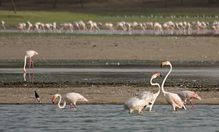
Thol Lake is an artificial lake near Thol village in Kadi in Mehsana District in the Indian state of Gujarat. A fresh water lake surrounded by marshes, it was built as an irrigation tank in 1912. Declared the Thol Bird Sanctuary in 1988, it is a habitat to 150 species of birds, about 60% of them waterbirds. Many migratory birds nest and breed in the lake and its periphery. The two most prominent species of birds recorded in the sanctuary are flamingoes and sarus crane. The sanctuary is also proposed to be declared an Eco-Sensitive Zone, conforming to the Environment (Protection) Act, 1986, for which draft notification has been prepared.
Sri Lanka exhibits a remarkable biological diversity and is considered to be the richest country in Asia in terms of species concentration.
