The longleaf pine is a pine species native to the Southeastern United States, found along the coastal plain from East Texas to southern Virginia, extending into northern and central Florida. In this area it is also known as "yellow pine" or "long leaf yellow pine", although it is properly just one out of a number of species termed yellow pine. It reaches a height of 30–35 m (98–115 ft) and a diameter of 0.7 m (28 in). In the past, before extensive logging, they reportedly grew to 47 m (154 ft) with a diameter of 1.2 m (47 in). The tree is a cultural symbol of the Southern United States, being the official state tree of Alabama. This particular species is one of the eight pine tree species that falls under the "Pine" designation as the state tree of North Carolina.
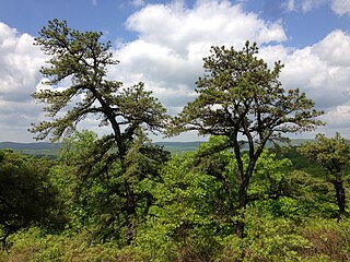
Pinus rigida, the pitch pine, is a small-to-medium-sized pine. It is native to eastern North America, primarily from central Maine south to Georgia and as far west as Kentucky. It is found in environments which other species would find unsuitable for growth, such as acidic, sandy, and low-nutrient soils.

Pinus serotina, the pond pine, black bark pine, bay pine,marsh pine, or pocosin pine, is a pine tree found along the Southeastern portion of the Atlantic coastal plain of the United States, from southern New Jersey south to Florida and west to southern Alabama. Pond pine distribution may be starting to spread west towards Mississippi and Tennessee.

Pinus elliottii, commonly known as slash pine, is a conifer tree native to the Southeastern United States. Slash pine is named after the "slashes" – swampy ground overgrown with trees and bushes – that constitute its habitat. Other common names include swamp pine, yellow slash pine, and southern Florida pine. Slash pine has two different varieties: P. e. var. elliottii and P. e. var. densa. Historically, slash pine has been an important economic timber for naval stores, turpentine, and resin. The wood of slash pine is known for its unusually high strength, especially for a pine. It exceeds many hardwoods and is even comparable to very dense woods such as black ironwood.
The Northeastern coastal forests are a temperate broadleaf and mixed forests ecoregion of the northeast and middle Atlantic region of the United States. The ecoregion covers an area of 34,630 sq miles (89,691 km2) encompassing the Piedmont and coastal plain of seven states, extending from coastal southwestern Maine, southeastern New Hampshire, eastern Massachusetts, and Rhode Island, southward through Connecticut, New York State, New Jersey, southeast Pennsylvania, Delaware and Maryland.

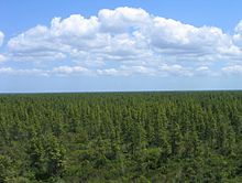
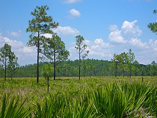
Flatwoods, pineywoods, pine savannas and longleaf pine–wiregrass ecosystem are terms that refer to an ecological community in the southeastern coastal plain of North America. Flatwoods are an ecosystem maintained by wildfire or prescribed fire and are dominated by longleaf pine, and slash pine in the tree canopy and saw palmetto, gallberry and other flammable evergreen shrubs in the understory, along with a high diversity of herb species. It was once one of the dominant ecosystem types of southeastern North America. Although grasses and pines are characteristic of this system, the precise composition changes from west to east, that is, from Texas to Florida. In Louisiana, savannas even differ between the east and west side of the Mississippi River. The key factor maintaining this habitat type is recurring fire. Without fire, the habitat is eventually invaded by other species of woody plants.

The Atlantic coastal pine barrens is a now rare temperate coniferous forest ecoregion of the Northeast United States distinguished by unique species and topographical features, generally nutrient-poor, often acidic soils and a pine tree distribution once controlled by frequent fires.
Pine barrens, pine plains, sand plains, or pineland areas occur throughout the U.S. from Florida to Maine as well as the Midwest, West, and Canada and parts of Eurasia. Perhaps the most well known pine-barrens area to North Americans is the New Jersey Pine Barrens. Pine barrens are generally pine forests in otherwise "barren" and agriculturally challenging areas. Such pine forests often occur on dry, acidic, infertile soils, and also include grasses, forbs, and low shrubs. The most extensive pine barrens occur in large areas of sandy glacial deposits, lakebeds, and outwash terraces along rivers.
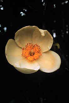
Gordonia lasianthus is a small to medium-sized evergreen tree or shrub found in acidic, swampy soils of pinelands and bays on the Atlantic and Gulf Coastal Plains of the southeastern United States. It is a member of the tea or family Theaceae. It is slow growing with soft, light-colored, fine-grained wood of little commercial value, although loblolly-bay could be managed as a source of pulpwood. When older specimens are cut, the wood exudes a strong scent. It is similar to a mixture of fresh oranges and pine sap. The bark of the adult tree varies from medium grey to a red brown coloration. Dead adult specimens of loblolly bay exhibit a lustrous shine when exposed to sunlight for several years. The white showy flowers and shiny foliage make it a desirable ornamental, but it is not easy to cultivate. Deer browse stump sprouts heavily.

The Appalachian mixed mesophytic forests is an ecoregion of the temperate broadleaf and mixed forests biome, as defined by the World Wildlife Fund. It consists of mesophytic plants west of the Appalachian Mountains in the Southeastern United States.

California oak woodland is a plant community found throughout the California chaparral and woodlands ecoregion of California in the United States and northwestern Baja California in Mexico. Oak woodland is widespread at lower elevations in coastal California; in interior valleys of the Coast Ranges, Transverse Ranges and Peninsular Ranges; and in a ring around the California Central Valley grasslands. The dominant trees are oaks, interspersed with other broadleaf and coniferous trees, with an understory of grasses, herbs, geophytes, and California native plants.

The New England-Acadian forests are a temperate broadleaf and mixed forest ecoregion in North America that includes a variety of habitats on the hills, mountains and plateaus of New England and New York State in the Northeastern United States, and Quebec and the Maritime Provinces of Eastern Canada.

The Eastern Cascades Slopes and Foothills ecoregion is a Level III ecoregion designated by the United States Environmental Protection Agency (EPA) in the U.S. states of Oregon, Washington, and California. In the rain shadow of the Cascade Range, the eastern side of the mountains experiences greater temperature extremes and receives less precipitation than the west side. Open forests of ponderosa pine and some lodgepole pine distinguish this region from the Cascades ecoregion, where hemlock and fir forests are more common, and from the lower, drier ecoregions to the east, where shrubs and grasslands are predominant. The vegetation is adapted to the prevailing dry, continental climate and frequent wildfire. Volcanic cones and buttes are common in much of the region.

The Klamath Mountains ecoregion of Oregon and California lies inland and north of the Coast Range ecoregion, extending from the Umpqua River in the north to the Sacramento Valley in the south. It encompasses the highly dissected ridges, foothills, and valleys of the Klamath and Siskiyou Mountains. It corresponds to the Level III ecoregion designated by the Environmental Protection Agency and to the Klamath-Siskiyou forests ecoregion designated by the World Wide Fund for Nature.

The Middle Atlantic coastal forests are a temperate coniferous forest mixed with patches of evergreen broadleaved forests along the coast of the southeastern United States.

The Southeastern mixed forests are an ecoregion of the temperate broadleaf and mixed forest biome, in the lower portion of the Eastern United States.

Lysimachia asperulifolia is a rare species of flowering plant in the Primulaceae known by the common name rough-leaved loosestrife and roughleaf yellow loosestrife. It is endemic to the Atlantic coastal plain in North Carolina and northern South Carolina in the United States, where there are 64 known populations. It is a federally listed endangered species of the United States.

Lyonia lucida is a species of flowering plant in the family Ericaceae known by the common names fetterbush lyonia, hurrahbush, and staggerbush. Other plants may also be called fetterbush. This broadleaved evergreen plant grows on the coastal plain of the southeastern United States from Virginia to Florida to Louisiana. It also occurs in Cuba.
A cypress dome is a type of freshwater forested wetland, or a swamp, found in the southeastern part of the United States. They are dominated by the Taxodium spp., either the bald cypress, or pond cypress. The name comes from the dome-like shape of treetops, formed by smaller trees growing on the edge where the water is shallow while taller trees grow at the center in deeper water. They usually appear as circular, but if the center is too deep, they form a “doughnut” shape when viewed from above. Cypress domes are characteristically small compared to other swamps, however they can occur at a range of sizes, dependent on the depth.
The Southeastern conifer forests are a temperate coniferous forest ecoregion of the southeastern United States. It is the largest conifer forest ecoregion east of the Mississippi River. It is also the southernmost instance of temperate coniferous forest within the Nearctic realm.