Dalgety, New South Wales

Last updated

Dalgety
New South Wales
Dalghetty.png
Main street of Dalgety and the Buckley's Crossing Hotel
Australia New South Wales location map blank.svg
Red pog.svg
Dalgety
Dalgety, New South Wales
Coordinates 36°30′0″S148°50′0″E / 36.50000°S 148.83333°E / -36.50000; 148.83333
Population252 (SAL 2021) [1]
Established1832
Postcode(s) 2628
Location
  • 51 km (32 mi) from Cooma
  • 452 km (281 mi) from Sydney
LGA(s) Snowy Monaro Regional Council
State electorate(s) Monaro
Federal division(s) Eden-Monaro

Dalgety is a small town in New South Wales, Australia, on the banks of the Snowy River between Melbourne and Sydney.

Contents

The town is located at what was once an important river crossing along the Travelling Stock route from Gippsland to the Snowy Mountains High Country dating from the 1840s.

History

The first settlement was originally known as Buckley's Crossing after Edward Buckley who established a farm near the river crossing in 1832. [2] It was renamed Barnes Crossing in 1848, [2] by which time it had become an important waypoint on the stock route between Gippsland in Victoria and the Snowy Mountains in New South Wales. In 1874 the town was formally surveyed and named Dalgety after the maiden name of the wife of surveyor J. R. Campbell. [3] Like the founder of Dalgety and Company she was a grandchild of a Colonel Alexander Dalgety. [4]

At the time of the survey the population was 23 and it was recorded that a punt was operating across the river. A Catholic school opened in 1874 to cater for the children of Irish gold prospectors, and the first bridge over the river was constructed in 1888. [2]

The town also became a meeting place between white settlers and local Aborigines, who would camp along the river bank on the way to the Snowy Mountains. [5] The Thaua people and Ngarigo people lived in this area seasonally. [6]

Location for national capital

Section 124 of the Constitution of the Commonwealth ordained that the 'Seat of Government' 'shall be in the State of New South Wales, and be distant not less than one hundred miles from Sydney', with the specific location to be decided by the Commonwealth Parliament.

Extract of map showing Dalgety as the Commonwealth Capital (1907) Extract of NSW Map (1907) showing Dalgety as Commonwealth Capital.jpg
Extract of map showing Dalgety as the Commonwealth Capital (1907)

In 1903 a Federal Royal Commission proposed Dalgety as the location for Australia's national capital city. The choice was ostensibly based on several criteria, including climate, food supply, land ownership and ability to support major industries, [7] although official investigators conceded the site was 'very rough', 'treeless', and 'somewhat exposed [to] high winds'. [8] The recommendation was implemented in the Seat of Government Act 1904 , and emphatically supported by the prime minister, George Reid, and the Minister for the Interior, John Forrest, even though he had told the Federal Australasian Convention of 1897 that 'only lunatics' would site the capital in the interior of the Commonwealth. [9]

The decision was immediately opposed by the Parliament of New South Wales which argued that Dalgety was too close to Melbourne and too far from Sydney. [10] A more practical objection was the distance to the main Sydney-Melbourne railway line and the expense involved in constructing a spur to the proposed capital. [11] Dalgety's cause had strong advocates including the local member Austin Chapman, Andrew Fisher, and John Forrest, as well as more general support from Victoria. [12] [13]

The matter eventually was settled, in October 1908, when parliamentarians voted on the capital site in a series of ballots, during which sites were eliminated progressively. In the ninth and last ballot, Dalgety had lost to 'Yass-Canberra' by 33 votes to 39. [14] [15] [16] Subsequently, the Seat of Government Act 1908 was passed, and Canberra became the capital. [5]

Considerable planning effort was made, during the period that Dalgety was the selected site of the new capital, including planning for the water supply and hydro-electric power generation [17] —a large reservoir was proposed for the Snowy River at Jindabyne [18] —and the routes for future rail lines. [19]

Geography

Dalgety is situated on the Snowy River, seen here from a bridge on the west side of the town. Dalgety NSW river Stevage.jpg
Dalgety is situated on the Snowy River, seen here from a bridge on the west side of the town.

Situated on the Monaro Plains and in the rain shadow of the Snowy Mountains, Dalgety is a relatively dry area of rolling hills with granite boulders scattered across the landscape.

The town depends on the Snowy River for water supplies. In October 2007 the New South Wales Department of Water and Energy recommended a cut in river flows through the nearby Lake Jindabyne, to a level which may require Dalgety to import drinking water. [20]

Related Research Articles

<span class="mw-page-title-main">Snowy Mountains Scheme</span> Dam in Kosciuszko National Park, New South Wales

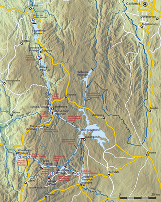
The Snowy Mountains Scheme, also known as the Snowy Hydro or the Snowy scheme, is a hydroelectricity and irrigation complex in south-east Australia. Near the border of New South Wales and Victoria, the scheme consists of sixteen major dams; nine power stations; two pumping stations; and 225 kilometres (140 mi) of tunnels, pipelines and aqueducts that were constructed between 1949 and 1974. The Scheme was completed under the supervision of Chief Engineer, Sir William Hudson. It is the largest engineering project undertaken in Australia.

<span class="mw-page-title-main">Lake George (New South Wales)</span> Town in New South Wales, Australia

Lake George is an endorheic lake in south-eastern New South Wales, Australia. It is approximately 40 kilometres (25 mi) north-east of Canberra located adjacent to the Federal Highway en route to Goulburn and Sydney. Lake George is also the name of a locality on the western and southern edges of the lake, within the area of the Queanbeyan–Palerang Regional Council.

The history of Canberra details the development of the city of Canberra from the time before European settlement to the city's planning by the Chicago architect Walter Burley Griffin in collaboration with Marion Mahony Griffin, and its subsequent development to the present day.

<span class="mw-page-title-main">Snowy River</span> River in south-eastern Australia

The Snowy River is a major river in south-eastern Australia. It originates on the slopes of Mount Kosciuszko, Australia's highest mainland peak, draining the eastern slopes of the Snowy Mountains in New South Wales, before flowing through the Alpine National Park and the Snowy River National Park in Victoria and emptying into Bass Strait.

<span class="mw-page-title-main">Bombala, New South Wales</span> Town in New South Wales, Australia

Bombala is a town in the Monaro region of south-eastern New South Wales, Australia, in Snowy Monaro Regional Council. It is approximately 485 kilometres (301 mi) south of the state capital, Sydney, and 80 kilometres (50 mi) south of the town of Cooma. The name derives from an Aboriginal word meaning "Meeting of the waters". The town lies on the banks of the Bombala River. At the 2021 census, Bombala had a population of 1,892.

<span class="mw-page-title-main">Tumut</span> Town in New South Wales, Australia

Tumut is a town in the Riverina region of New South Wales, Australia, situated on the banks of the Tumut River.

<span class="mw-page-title-main">Monaro (New South Wales)</span> Region in New South Wales, Australia

Monaro, once frequently spelt "Manaro", or in early years of settlement "Maneroo" is a region in the south of New South Wales, Australia. A small area of Victoria near Snowy River National Park is geographically part of the Monaro. While the Australian Capital Territory is not considered part of the region, some towns in the Monaro have close links with Canberra.

<span class="mw-page-title-main">Jindabyne, New South Wales</span> Town in New South Wales, Australia

Jindabyne is a town in south-east New South Wales, Australia that overlooks Lake Jindabyne near the Snowy Mountains, in Snowy Monaro Regional Council. It is a popular holiday destination year round, especially in winter. This is due to its proximity to major ski resort developments within the Kosciuszko National Park, including Thredbo, Perisher and Charlotte Pass.

<span class="mw-page-title-main">Lyndhurst, New South Wales</span> Town in New South Wales, Australia

Lyndhurst is a small village in New South Wales, Australia in Blayney Shire. It is 4 kilometres west of Mandurama or about 269 km west of Sydney and 63 km south-west of Bathurst just off the Mid-Western Highway New South Wales. Once serving as the major centre for basic goods and needs to the nearby Junction Reefs goldfields. At the 2016 census, Lyndhurst had a population of 267 people.

<span class="mw-page-title-main">Snowy River Shire</span> Former local government area in New South Wales, Australia

The Snowy River Shire was a local government area in the Australian Alps region of New South Wales, Australia from 1939 until May 2016. It was named after the Snowy River that runs through it. Prior to 1936, it had been named as Dalgety Shire since establishment in 1906.

<span class="mw-page-title-main">John Gale (journalist)</span> Australian journalist and politician (1831–1929)

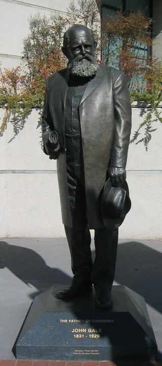
John Gale was an Australian newspaper proprietor, lay preacher and politician. He was the founder of The Queanbeyan Age, the first newspaper to serve the Queanbeyan district in New South Wales. He was also an advocate for the Queanbeyan-Canberra area as the best site of a future Australian national capital, for which he is sometimes called the "Father of Canberra". He served a single term as Member for Murrumbidgee in the New South Wales Legislative Assembly.

<span class="mw-page-title-main">Tooma, New South Wales</span> Town in New South Wales, Australia

Tooma is a locality and village community in the Snowy Valleys Council local government area, in the eastern part of the Riverina region of New South Wales.

Cooma–Snowy Mountains Airport is an airport located in Coolringdon, 9 nautical miles southwest of Cooma, New South Wales, Australia. The airport serves the town of Cooma and the resorts of the Snowy Mountains and Australian Alps, experiencing increased traffic during the winter months.

Numeralla, is a village in Snowy Monaro Region of New South Wales, Australia. The name is also applied to the surrounding area, for postal and statistical purposes. In 2016, the population of the village and its surrounding area was 258. The village was known as Umaralla until 1972.

Bumbalong is a rural locality in the Snowy Monaro Region, New South Wales, Australia. Although it lies in the valley of the Murrumbidgee River, it is sometimes referred to by its residents as Bumbalong Valley. At the 2016 census, it had a population of 24.

Little River is a rural locality in the Snowy Valleys Council local government area of New South Wales, Australia. It lies is 6 km east of Tumut, in the southern side of the valley of the Goobarragandra River, just to the east of the confluence of that river with the Tumut River. The Goobarragandra River was once also known as 'Tumut Little River' or just as 'Little River', giving rise to the locality's name. At the 2021 census, it had a population of 38.

<span class="mw-page-title-main">Coolringdon</span> Town in New South Wales, Australia

Coolringdon is a locality in the Local Government Area of the Snowy Monaro Regional Council, in the Monaro region of New South Wales, Australia. It lies in the foothills of the Snowy Mountains, west of Cooma. At the 2021 census, there were 73 people usually residing in Coolringdon. The Cooma-Snowy Mountains Airport is located within the locality. Coolringdon is notable as being one of the proposed sites for Australia's national capital, prior to the selection of Canberra.

Mahkoolma was the name given to one of the sites proposed for Australia's national capital city, prior to selection of Canberra. The name Mahkoolma is not used today, and the once proposed city site now lies across the boundary of the modern-day localities of Bookham and Burrinjuck, New South Wales.

<span class="mw-page-title-main">Stewart Ryrie, Junior</span> Scottish-born Australian pastoralist, surveyor, and settler colonist (1812—1882)

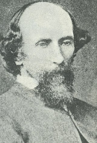
Stewart Ryrie, Junior (1812—1882) was a Scottish-born Australian pastoralist, surveyor and settler colonist of the Monaro district of New South Wales, Australia. He is associated with early colonial settlement of the Cooma and Jindabyne areas, and the exploration and survey of the Snowy Mountains.

<span class="mw-page-title-main">Rock Flat, New South Wales</span> Town in New South Wales, Australia

Rock Flat is a rural locality in the Snowy Monaro Regional Council local government area of New South Wales, Australia. It is located south of Cooma, on either side of the Monaro Highway.

References

  1. Australian Bureau of Statistics (28 June 2022). "Dalgety (suburb and locality)". Australian Census 2021 QuickStats. Retrieved 28 June 2022.  OOjs UI icon edit-ltr-progressive.svg
  2. 1 2 3 "Travel:Dalgety". Sydney Morning Herald. 8 February 2004. Retrieved 9 November 2007.
  3. "Dalgety". Geographical Names Register (GNR) of NSW. Geographical Names Board of New South Wales . Retrieved 4 August 2013. OOjs UI icon edit-ltr-progressive.svg
  4. Wynford Vaughan-Thomas. Dalgety, The Romance of a Business, Henry Melland, London 1984 ISBN   0907929079
  5. 1 2 "Dalgety". Tourism New South Wales. November 2007. Retrieved 9 November 2007.[ permanent dead link ]
  6. Tindale, Norman (1974) "Thaua" in his Catalogue of Australian Aboriginal Tribes. South Australian Museum. Archived 18 April 2008 at the Wayback Machine Quote: the Bemerigal or mountain people at Cooma belonged to the Ngarigo.
  7. "A Guide to NSW State Archives relating to Federation". State Records New South Wales. October 2001. Archived from the original on 27 September 2007. Retrieved 9 November 2007.
  8. William Coleman,Their Fiery Cross of Union. A Retelling of the Creation of the Australian Federation, 1889-1914, Connor Court, Queensland, 2021, p.279.
  9. William Coleman,Their Fiery Cross of Union. A Retelling of the Creation of the Australian Federation, 1889-1914, Connor Court, Queensland, 2021, p424.
  10. Pegrum, Roger (1983). The Bush Capital: How Australia Chose Canberra as Its Federal City. Hale & Iremonger. ISBN   0-86806-066-6.
  11. Welsh, Frank (2005). Great Southern Land: A New History of Australia. Penguin Books. ISBN   0-7139-9450-9.
  12. "SEARCH FOR A CAPITAL". Goulburn Evening Penny Post. 21 August 1906. Retrieved 29 November 2021.
  13. "FEDERAL CAPITAL SITE. - SIR JOHN FORREST'S MINUTE. DALGETY STRONGLY RECOMMENDED. - The Argus (Melbourne, Vic. : 1848 - 1957) - 28 Apr 1904". Trove. Retrieved 10 October 2021.
  14. Sherrinton, G.E. (1969). "Submitted in requirement for the Degree of Master of Arts :THE SELECTION OF THE CAPITAL SITE IN FEDERAL POLITICS 1901-1909". pp. 202–220. Archived from the original on 20 June 2020.
  15. "AUSTRALIA'S CAPITAL". Sydney Morning Herald. 9 October 1908. Retrieved 2 October 2021.
  16. "CAPITAL SITE". Argus. 9 October 1908. Retrieved 10 October 2021.
  17. "Dalgety gravitation scheme for water supply [cartographic material]". Trove. Retrieved 11 May 2022.
  18. "Proposed reservoir at Jindabyne [cartographic material]". Trove. Retrieved 11 May 2022.
  19. "[Dalgety region][cartographic material] : to accompany my report of 27th October '05". Trove. Retrieved 11 May 2022.
  20. "Dalgety residents fear cut to Snowy flows". Australian Broadcasting Corporation. 2 October 2007. Retrieved 9 November 2007.