
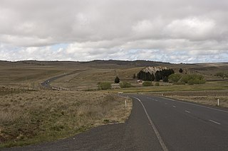
Monaro Highway is a 285-kilometre-long (177 mi) highway in Victoria, New South Wales, and the Australian Capital Territory, in Australia, linking Cann River in Victoria to Canberra in the Australian Capital Territory (ACT) via the Monaro region. From its southern terminus, it follows the nearby Cann River upstream towards the New South Wales border through heavily forested terrain. Within New South Wales (NSW), it makes its way through further forest before reaching the pastures typical of the Monaro. There are multiple towns and villages along the highway, including Bombala, Nimmitabel and Cooma. The terrain within the Monaro is largely hilly, and there are numerous crossings. The road also parallels the former Bombala railway line in several locations. Within the ACT, the road becomes a high volume roadway and serves the southern suburbs of Canberra. The highway has more recently had a grade-separated dual carriageway extension constructed within Canberra, as part of the Eastern Parkway construction project. It is designated part of route M23, and route A23 within Canberra, and route B23 within Victoria and New South Wales, with a concurrency where it also carries route B72 between the two sections of Snowy Mountains Highway.

Cooma is a town in the south of New South Wales, Australia. It is located 114 kilometres (71 mi) south of the national capital, Canberra, via the Monaro Highway. It is also on the Snowy Mountains Highway, connecting Bega with the Riverina.

Snowy Mountains Highway is a 333-kilometre-long (207 mi) state highway located in New South Wales, Australia. Its two sections connect the New South Wales South Coast to the Monaro region, and the Monaro to the South West Slopes via the Snowy Mountains. The higher altitude regions of this road are subject to snow over the winter months, and the road also provides access to many parts of the Snowy Mountains Scheme. The highway bears the B72 shield along its entire length.

Berridale is a small town in New South Wales. At the 2021 census it had a population of 1,300. It was the administrative centre of the Snowy River Shire until in 2016 that shire merged with two others to form the Snowy Monaro Regional Council, one of Australia's major inland tourist destinations. Berridale lies at 860 metres above sea level between the towns of Cooma and Jindabyne and 435 kilometres south of Sydney.

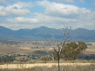
Monaro, once frequently spelt "Manaro", or in early years of settlement "Maneroo" is a region in the south of New South Wales, Australia. A small area of Victoria near Snowy River National Park is geographically part of the Monaro. While the Australian Capital Territory is not considered part of the region, some towns in the Monaro have close links with Canberra.
Michelago is a village in the Monaro region of New South Wales, Australia. The village is in the Snowy Monaro Regional Council local government area, 54 kilometres (34 mi) south of Canberra on the Monaro Highway. It was founded in the 1820s, on the main route from Sydney to the Snowy Mountains. Its name is also applied to the surrounding area, for postal and statistical purposes. At the 2016 census, Michelago had a population of 562.

Bredbo is a village on the Monaro plains of New South Wales, Australia. The village is on the Monaro Highway 34 kilometres (21 mi) north of Cooma. The village is in the Snowy Monaro Regional Council and had a population of 352 at the 2016 census.

The geology of the Australian Capital Territory includes rocks dating from the Ordovician around 480 million years ago, whilst most rocks are from the Silurian. During the Ordovician period the region—along with most of eastern Australia—was part of the ocean floor. The area contains the Pittman Formation consisting largely of quartz-rich sandstone, siltstone and shale; the Adaminaby Beds and the Acton Shale.

Monaro, also known as Maneroo (1856–1858), Monara (1858–1879) and Manaro (1894–1904) is an electoral district of the Legislative Assembly in the Australian state of New South Wales. It is currently represented by Steve Whan of the Labor party since the 2023 New South Wales state election.

Williamsdale is a town in the district of Tuggeranong, in the Australian Capital Territory in Australia. Is situated on the northwest side of the Australian Capital Territory border abutting the town of Williamsdale in the Southern Tablelands region of New South Wales, Australia. The Monaro Highway and the former Bombala railway pass through the area. A railway station saw service until 1975. The postcode is 2620.

Cooma-Monaro Shire was a local government area located in the Monaro region of southern New South Wales, Australia. The area was named after the former Cooma Municipality and the former Monaro Shire, that were amalgamated to create it. The Municipality of Cooma was established in 1879, and the Monaro Shire was one of several shires established in 1906. The Monaro Shire and Cooma Municipal Council amalgamated in 1981. On 11 February 2004, Cooma-Monaro Shire absorbed a small part of the former Yarrowlumla Shire, near Michelago.
Charles Lachlan "Charlie Mac" McKeahnie was an Australian horseman born in Gudgenby, ACT to Alexander and Mary McKeahnie into a family of five sisters. He is believed by some historians to be the inspiration for the poem "The Man from Snowy River" by Banjo Paterson.
Williamsdale is a locality situated immediately on the south-east side of the New South Wales border abutting the locality of Williamsdale in south-eastern Australian Capital Territory, Australia. The Monaro Highway and the former Bombala railway pass through the village. A railway station saw service from 1891 until 1975. The postcode is 2620.
The Cooma Creek, a mostly–perennial river that is part of the Murrumbidgee catchment within the Murray–Darling basin, is located in the Monaro region of New South Wales, Australia.
Rock Flat Creek is a watercourse that is part of the Murrumbidgee catchment within the Murray–Darling basin. It is located in the Monaro region of New South Wales, Australia.

The Snowy Monaro Regional Council is a local government area located in the Snowy Mountains and Monaro regions of New South Wales, Australia. The council was formed on 12 May 2016 through a forced merger of the Bombala, Cooma-Monaro and Snowy River shires.

Colinton is a locality in the Snowy Monaro Region, New South Wales, Australia. At the 2021 census, it had a population of 115. There was once a village and railway station of the same name.

Bunyan is a locality in the Snowy Monaro Region, New South Wales, Australia. It lies on the eastern side of the Murrumbidgee River and on both sides of the Monaro Highway about 110 km south of Canberra and about 10 km north of Cooma. At the 2016 census, it had a population of 152.
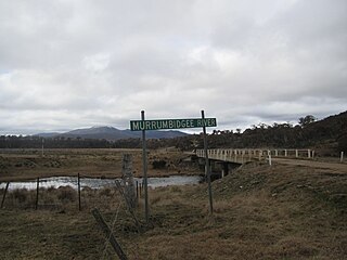
Yaouk is a locality in the Snowy Monaro Region, New South Wales, Australia. It lies in open grassland valleys surrounded by mountains on both sides of the Murrumbidgee River, downstream from and east of the Tantangara Dam, north of Adaminaby, east of the Kosciuszko National Park and south of the Namadgi National Park in the Australian Capital Territory, but separated from it by the mountainous Scabby Range. It is about 110 km south of Canberra and about 75 km northwest of Cooma. At the 2016 census, it had a population of 25.

Old Adaminaby and Lake Eucumbene are the heritage-listed former town of Adaminaby and the reservoir that flooded the town, now at Eucumbene, Snowy Valleys Council, New South Wales, Australia. The town was established in 1830. The reservoir was designed by the Snowy Hydro Electric Authority and built from 1956 to 1958 by the Authority. It is also known as Old Adaminaby and Lake Eucumbene, including relics and movable objects, Eucumbene River, Eucumbene Valley, Old Adaminaby Remains, Old Adaminaby Ruins and Old Adaminaby Drowned Landscape. The property is owned by Snowy Hydro Limited, a statutory corporation owned by the governments of Australia, New South Wales and Victoria. The site was added to the New South Wales State Heritage Register on 3 June 2008.

