Barry Way

Last updated

Barry Way

Barry Way Jindabyne Stevage.jpeg
The start of the Barry Way, near Jindabyne, NSW.
Barry Way
General information
Type Track
Length71.6 km (44 mi)
Major junctions
North end
South end

The Barry Way is a partly unsealed alpine road running from Jindabyne southwest to the Victoria border, in New South Wales, Australia, where it becomes the Snowy River Road. It eventually leads to Buchan, a total distance of 170 kilometres with no services or towns. It is sealed for the first 27 kilometres from Jindabyne, becoming unsealed at Ingebirah Gap, remaining so as far as the Victorian border. The road passes through some very remote and unspoilt wilderness in the Australian Alps. The scenery along the road provides views of the Snowy River valley and the surrounding mountains. There are a number of campsites along the road, from Jacobs River southwards.

Contents

During the summer months, the weather on the Barry Way can be extremely hot and the road may be temporarily closed due to bushfires. In winter the road north of the Victorian border can be closed for considerable periods of time due to heavy snowfalls and dangerous ice. The gravel section can be challenging for 2WD vehicles and caravans. This road has no major intersections between Jindabyne and the Victorian border, and no petrol is available.

At the NSW/VIC border, the Barry Way becomes known as Snowy River Road and continues southward into the Gippsland region of Victoria.

History

The road is named after Leo Barry, president of the Snowy River Shire Council in the 1950s, who pushed for the creation of the road.

Construction of the Victorian portion of the road began as early as 1925 when a bridge was built over the Buchan River at Buchan. In the 1930s with the use of unemployed labourers, improvements were made to the Buchan-Gelantipy portion of the road. Work had progressed as far as the construction of the bridge over the Suggan Buggan River at Suggan Buggan when the start of the Second World War stopped work in 1939. All of the work completed up to this point in time was done using picks and shovels, with bullock teams employed to cart away the fill. All the stonework for the culverts, pipes and embankments was constructed by hand using stone recovered during the road making process.

It was not until 1960 that the Tambo and Snowy River shires managed to secure funding to complete what was described as a jeep track (that would later be upgraded) connecting the Victorian and NSW sections built before the war. A Mr L. Livingstone was contracted to undertake the Victorian portion from Suggan Buggan to Willis on the Victorian-NSW border. The job took 26 weeks to complete with the Victorians reaching the border shortly before the New South Wales construction crew. The road was opened in May 1961 by Leo Barry (Snowy River Shire) and Keith Rogers (Tambo Shire), with some 400 people in attendance. Avalanche Lookout was constructed in these works. [1]

See also

Related Research Articles

<span class="mw-page-title-main">Snowy Mountains</span> Mountain range in Australia

The Snowy Mountains, known informally as "The Snowies", is an IBRA subregion in southern New South Wales, Australia, and is the tallest mountain range in mainland Australia, being part of the continent's Great Dividing Range cordillera system. It makes up the northeastern half of the Australian Alps and contains Australia's five tallest peaks, all of which are above 2,100 m (6,890 ft), including the tallest Mount Kosciuszko, which reaches to a height of 2,228 m (7,310 ft) above sea level. The offshore Tasmanian highlands makes up the only other major alpine region present in the whole of Australia.

<span class="mw-page-title-main">Snowy Mountains Scheme</span> Dam in Kosciuszko National Park, New South Wales

The Snowy Mountains Scheme, also known as the Snowy Hydro or the Snowy scheme, is a hydroelectricity and irrigation complex in south-east Australia. Near the border of New South Wales and Victoria, the scheme consists of sixteen major dams; nine power stations; two pumping stations; and 225 kilometres (140 mi) of tunnels, pipelines and aqueducts that were constructed between 1949 and 1974. The Scheme was completed under the supervision of Chief Engineer, Sir William Hudson. It is the largest engineering project undertaken in Australia.

<span class="mw-page-title-main">Monaro Highway</span> Highway in Australia

Monaro Highway is a 285-kilometre-long (177 mi) highway in Victoria, New South Wales, and the Australian Capital Territory, in Australia, linking Cann River in Victoria to Canberra in the Australian Capital Territory (ACT) via the Monaro region. From its southern terminus, it follows the nearby Cann River upstream towards the New South Wales border through heavily forested terrain. Within New South Wales (NSW), it makes its way through further forest before reaching the pastures typical of the Monaro. There are multiple towns and villages along the highway, including Bombala, Nimmitabel, and Cooma. The terrain within the Monaro is largely hilly, and there are numerous crossings. The road also parallels the former Bombala railway line in several locations. Within the ACT, the road becomes a high volume roadway and serves the southern suburbs of Canberra. The highway has more recently had a grade-separated dual carriageway extension constructed within Canberra, as part of the Eastern Parkway construction project. It is designated part of route M23, and route A23 within Canberra, and route B23 within Victoria and New South Wales, with a concurrency where it also carries route B72 between the two sections of Snowy Mountains Highway.

<span class="mw-page-title-main">Alpine Way</span>

The 
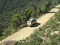
Alpine Way is a 121-kilometre (75 mi) rural road located in the Snowy Mountains region of New South Wales, Australia. The road connects Jindabyne in the east to the New South Wales / Victorian border in the west, crossing the Murray River, near Bringenbrong / Upper Towong. The route does not carry an official shield designation.

<span class="mw-page-title-main">Charlotte Pass, New South Wales</span> Ski resort in New South Wales, Australia

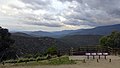
Charlotte Pass is a snow resort and village in the Snowy Mountains of New South Wales, Australia. The pass is in the Kosciuszko National Park where the Kosciuszko Road crosses Kangaroo Ridge. Charlotte Pass is the closest village to Mount Kosciuszko, the tallest mountain in Australia.

<span class="mw-page-title-main">Snowy River</span> River in south-eastern Australia

The Snowy River is a major river in south-eastern Australia. It originates on the slopes of Mount Kosciuszko, Australia's highest mainland peak, draining the eastern slopes of the Snowy Mountains in New South Wales, before flowing through the Alpine National Park and the Snowy River National Park in Victoria and emptying into Bass Strait.

<span class="mw-page-title-main">Murray Valley Highway</span> Highway in Victoria and New South Wales

Murray Valley Highway is a 663-kilometre (412 mi) state highway located in Victoria and New South Wales, Australia. The popular tourist route mostly follows the southern bank of the Murray River and effectively acts as the northernmost highway in Victoria. For all but the western end's last three kilometres, the highway is allocated route B400.

<span class="mw-page-title-main">Berridale, New South Wales</span> Town in New South Wales, Australia

Berridale is a small town in New South Wales. At the 2021 census it had a population of 1,300. It was the administrative centre of the Snowy River Shire until in 2016 that shire merged with two others to form the Snowy Monaro Regional Council, one of Australia's major inland tourist destinations. Berridale lies at 860 metres above sea level between the towns of Cooma and Jindabyne and 435 kilometres south of Sydney.

<span class="mw-page-title-main">East Gippsland</span> Region of Victoria, Australia

East Gippsland is the eastern region of Gippsland, Victoria, Australia covering 31,740 square kilometres (14%) of Victoria. It has a population of 80,114.

<span class="mw-page-title-main">Jindabyne, New South Wales</span> Town in New South Wales, Australia

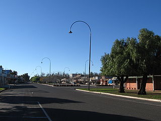
Jindabyne is a town in south-east New South Wales, Australia that overlooks Lake Jindabyne near the Snowy Mountains, in Snowy Monaro Regional Council. It is a popular holiday destination year round, especially in winter. This is due to its proximity to major ski resort developments within the Kosciuszko National Park, including Thredbo, Perisher and Charlotte Pass.

<span class="mw-page-title-main">Jindabyne Dam</span> Dam in Snowy Mountains, New South Wales

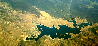
Jindabyne Dam is a major ungated rockfill embankment dam across the Snowy River in the Snowy Mountains of New South Wales, Australia. The dam's main purpose is for the generation of hydro-power and is one of the sixteen major dams that comprise the Snowy Mountains Scheme, a vast hydroelectricity and irrigation complex constructed in south-east Australia between 1949 and 1974 and now run by Snowy Hydro.

<span class="mw-page-title-main">Thredbo River</span> River in New South Wales, Australia

The Thredbo River, a perennial river of the Snowy River catchment, is located in the Snowy Mountains region of New South Wales, Australia.

<span class="mw-page-title-main">Khancoban</span> Town in New South Wales, Australia

Khancoban is a small town in Snowy Valleys Council, New South Wales, Australia. The town is located 567 kilometres (352 mi) from the state capital, Sydney and 13 kilometres (8 mi) from the state border with Victoria, in the foothills of the Snowy Mountains, near the upper reaches of the Murray River. At the 2016 census, Khancoban had a population of 304.
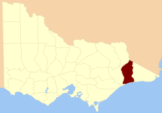
<span class="mw-page-title-main">Suggan Buggan River</span> River in Victoria, Australia

The Suggan Buggan River is a perennial river of the Snowy River catchment, located in the Alpine region of the Australian state of Victoria.

The Mowamba River, a perennial river of the Snowy River catchment, is located in the Snowy Mountains region of New South Wales, Australia.

Bonang Road is a rural road in south-eastern Australia, running generally south–north. It links the Gippsland region coastal town of Orbost, Victoria and the highland Monaro region town of Bombala, New South Wales.

<span class="mw-page-title-main">Buchan River</span> River in Victoria, Australia

The Buchan River is a perennial river of the Snowy River catchment, located in the Alpine region of the Australian state of Victoria.

<span class="mw-page-title-main">Berrima River</span> River in Victoria, Australia

The Berrima River, also called the Berrima Creek, is a perennial river of the Snowy River catchment, located in the Alpine region of the Australian states of New South Wales and Victoria.

<span class="mw-page-title-main">Suggan Buggan, Victoria</span> Locality in Victoria, Australia

Suggan Buggan is a ghost town in the remote wilderness of north-eastern Gippsland in Victoria, Australia, 8 km from the border with New South Wales. About five or six people live there permanently. The postcode is 3885.

<span class="mw-page-title-main">Gelantipy</span> Town in Victoria, Australia

Gelantipy is a rural locality 49 km. north of Buchan in the East Gippsland region of Australia. There are also two adjoining parishes, Gelantipy East and Gelantipy West, that cover portions of the locality. Wulgulmerang, W Tree and Brumby localities are nearby.

References

  1. Department of the Environment. "Snowy River Road (Victorian Section), Snowy River Rd, Buchan, VIC, Australia". Australian Heritage Database. Commonwealth of Australia. Archived from the original on 6 May 2014. Retrieved 6 May 2014.

36°29′S148°34′E / 36.483°S 148.567°E / -36.483; 148.567

CC BY icon-80x15.png  This article incorporates text available under the CC BY 3.0 AU licence.Required attribution: © Commonwealth of Australia 2013