The Sydney Harbour Bridge is a steel through arch bridge in Sydney, New South Wales, Australia, spanning Sydney Harbour from the central business district (CBD) to the North Shore. The view of the bridge, the Harbour, and the nearby Sydney Opera House is widely regarded as an iconic image of Sydney, and of Australia itself. Nicknamed "The Coathanger" because of its arch-based design, the bridge carries rail, vehicular, bicycle and pedestrian traffic.

Gladesville Bridge is a heritage-listed concrete arch road bridge that carries Victoria Road over the Parramatta River, linking the Sydney suburbs of Huntleys Point and Drummoyne, in the local government areas of Canada Bay and Hunter's Hill, in New South Wales, Australia. Despite its name, the bridge is not in Gladesville.
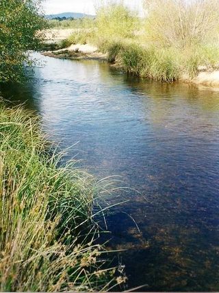
The Shoalhaven River is a perennial river that rises from the Southern Tablelands and flows into an open mature wave dominated barrier estuary near Nowra on the South Coast of New South Wales, Australia.

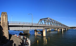
The Ryde Bridge, also called the Uhrs Point Bridge, are two road bridges that carry Concord Road, part of the A3, across Parramatta River from Ryde in the northern suburbs of Sydney to Rhodes in Sydney's inner west, in New South Wales, Australia.
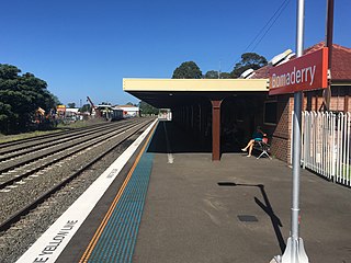
Bomaderry railway station is a heritage-listed single-platform intercity train station located in Bomaderry, New South Wales, Australia, on the South Coast railway line. The station serves NSW TrainLink diesel multiple unit trains to Kiama. Early morning and late night services to the station are provided by train replacement bus services. A siding near the station is used by freight trains operated by the Manildra Group.
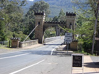
Hampden Bridge is a heritage-listed single-span suspension bridge that carries Moss Vale Road (B73) across the Kangaroo River, in Kangaroo Valley, in the City of Shoalhaven local government area of New South Wales, Australia. The bridge was designed by Ernest de Burgh and built by Loveridge and Hudson. The property is owned by Transport for NSW. It was added to the New South Wales State Heritage Register on 2 August 2019.

The Fig Tree Bridge is a road bridge that carries Burns Bay Road across the Lane Cove River, and connects the suburbs of Hunters Hill in the south and Linley Point in the north, located approximately seven kilometres northwest of the central business district of Sydney in New South Wales, Australia. The concrete girder bridge carries motor vehicles, and a grade-separated footpath and cycleway.
Tom Uglys Bridge are two road bridges, completed in 1929 and 1987, that carry the Princes Highway across the Georges River in southern Sydney, in the state of New South Wales, Australia. The bridges link the St George area at Blakehurst to the Sutherland Shire at Sylvania. Tom Uglys Bridge is one of six major road crossings of Georges River.

Alfords Point Bridge is a twin 445-metre-long (1,460 ft) concrete and steel box girder road bridge that carries Alford Point Road as state route A6 across the lower Georges River between Padstow Heights in the City of Canterbury-Bankstown and Alfords Point in the Sutherland Shire in Sydney, New South Wales, Australia.

The Victoria Bridge, also known as the Victoria Bridge over the Nepean River, is a heritage-listed former railway bridge and now wrought iron box plate girder road bridge across the Nepean River on the Great Western Highway in the western Sydney suburb of Penrith in the City of Penrith local government area of New South Wales, Australia. The bridge was designed by John Whitton, the Engineer–in–Chief of New South Wales Government Railways, and built from 1862 to 1867 by William Piper, Peto Brassey and Betts (superstructure), William Watkins (piers). It is also known as Victoria Bridge, The Nepean Bridge and RTA Bridge No. 333. It was added to the New South Wales State Heritage Register on 27 May 2016.

Fullers Bridge, officially called the Fullers Creek Bridge, is a road bridge that carries Delhi Road to Millwood Avenue across the Lane Cove River, in Chatswood West, Sydney, New South Wales, Australia. The concrete beam bridge is located 9 kilometres (5.6 mi) northwest of the Sydney central business district and connects Chatswood to North Ryde as part of the A38.

The Peats Ferry Bridge is a steel truss bridge that carries the Pacific Highway (B83) across the Hawkesbury River, between Kangaroo Point and Mooney Mooney Point, located 40 kilometres (25 mi) north of Sydney in New South Wales, Australia. The bridge carries the Hornsby to Kariong section of highway, while the adjacent Brooklyn Bridge carries the Pacific Motorway (M1).

The North–South Motorway is a partially complete motorway traversing the inner western suburbs of Adelaide, from Waterloo Corner in the north to Bedford Park in the south. Progressively constructed in stages since 2010, once complete it will replace the adjacent South Road as Adelaide's main north–south roadway. It will form the central section of the North–South Corridor, being flanked north and south by the Northern Expressway and Southern Expressway, respectively. It is designated part of route M2.
The Brooklyn Bridge is a local nickname for the Hawkesbury River Road Bridge, a concrete girder bridge that carries the Pacific Motorway (M1) across the Hawkesbury River between Kangaroo Point and Mooney Mooney Point, located 35 kilometres (22 mi) north of Sydney in New South Wales, Australia. The bridge comprises a dual carriageway with three lanes in each direction of motorway grade-separated conditions.

The Murray River railway bridge is a heritage-listed Australian railway bridge over the Murray River on the Main Southern line south of Albury in the City of Albury, New South Wales, and on the North Eastern line north of Wodonga in Victoria. The bridge was designed by John Whitton and built from 1883 to 1884 by J. S. Bennett, with iron work supplied by Westwood, Baillie, England. It is also known as the Rail Bridge over Murray River, Albury–Wodonga and the Albury Lattice Railway Bridge and Murray River Underbridge. The bridge is owned by RailCorp, and maintained by the Australian Rail Track Corporation as part of its lease of the line. It was added to the New South Wales State Heritage Register on 2 April 1999, and added to the Register of the National Estate on 18 April 1989.

Old Cobram-Barooga Bridge is a heritage-listed former road bridge and now footbridge over the Murray River at Barooga-Cobram Road, Barooga, New South Wales, Australia. The bridge links Barooga with Cobram, its sister town in Victoria. It was designed by Ernest de Burgh (engineer) and the New South Wales Department of Public Works and built from 1900 to 1902. It is also known as RMS Bridge No 3247. It is owned by Transport for NSW. It was added to the New South Wales State Heritage Register on 1 April 2016.

The Long Cove Creek railway viaducts are heritage-listed railway viaducts which carry the Main Suburban railway line over Long Cove Creek between the suburbs of Lewisham and Summer Hill in Sydney, New South Wales, Australia. The viaducts were designed and built by the New South Wales Government Railways. The property is owned by Transport Asset Holding Entity, an agency of the Government of New South Wales. It was added to the New South Wales State Heritage Register on 2 April 1999.

The Samuel-De Champlain Bridge, colloquially known as the Champlain Bridge, is a cable-stayed bridge design by architect Poul Ove Jensen and built to replace the original Champlain Bridge over the Saint Lawrence River in Quebec, between Nuns' Island in the borough of Verdun in Montreal and the suburban city of Brossard on the South Shore. A second, connected bridge links Nuns' Island to the main Island of Montreal. It is the busiest bridge in the country with more cars flowing into it than any other bridge.

The Long Gully Bridge, also known as Northbridge, Suspension Bridge, and Cammeray Bridge, is a concrete arch road bridge that carries Strathallen Avenue across Flat Rock Creek and Tunks Park, and connects the suburbs of Cammeray, in the North Sydney Council local government area to its south, with Northbridge in the City of Willoughby local government area to its north, in Sydney, New South Wales, Australia.
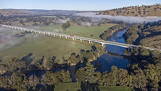
Sheahan Bridge is a dual carriageway bridge over the Murrumbidgee River on the Hume Highway in Gundagai, New South Wales. It is the third longest bridge in New South Wales after the Macleay Valley Bridge and Sydney Harbour Bridge, which at 1.149 km (0.714 mi) is only slightly longer than the Sheahan Bridge's 1.141 km (0.709 mi).