Giinagay Way

Last updated

Giinagay Way

Australia New South Wales location map blank.svg
Red pog.svg
South end
Red pog.svg
North end
Coordinates
General information
TypeRoad
Length45.8 km (28 mi) [1]
Gazetted 24 February 2017 [2]
(Warrell Creek to Valla)
14 July 2017 [3]
(Valla to Raleigh)
Former
route number
AUS Alphanumeric Route A1.svg (A1) (2013–2018)
Australian national route 1.svg (National Route 1) (until 2013)
Warrell Creek to Nambucca Heads
AUS Alphanumeric Route A1.svg (A1) (2013–2016)
Australian national route 1.svg (National Route 1) (until 2013)
Nambucca Heads to Urunga
Major junctions
South endAUS Alphanumeric Route A1.svg Pacific Highway
Eungai Creek, New South Wales
North endAUS Alphanumeric Route A1.svg Pacific Highway
AUS Alphanumeric Route B78.svg Waterfall Way
Raleigh, New South Wales
Location(s)
Region Mid North Coast
LGA(s) Bellingen Shire
Nambucca Valley Council
Major suburbs Macksville, Nambucca Heads, Urunga
Highway system

Giinagay Way is a road in the Mid North Coast region of New South Wales linking the towns of Warrell Creek, Macksville, Nambucca Heads and Urunga to Pacific Highway. It runs along a former section of the highway between Eungai Creek and Raleigh that was bypassed by a new parallel alignment between 2016 and 2018.

Contents

Giinagay means "Hello" or "Welcome" in the local Gumbaynggirr language. [4] [5]

Route description

Giinagay Way is a 45.8-kilometre (28.5 mi) road stretching from Eungai Creek to Raleigh and passes through the towns of Warrell Creek, Macksville, Nambucca Heads and Urunga. [1] The road passes through two local government areas, Bellingen Shire and Nambucca Valley Council.

History

Many sections of the Pacific Highway had been bypassed since 1996 as part of the Pacific Highway Upgrade. The section between Nambucca Heads to Urunga was due to be bypassed by a new alignment in 2016. Bellingen Shire Council chose "Giinagay Way" as the proposed name of the old alignment, meaning "Hello" or "Welcome" greeting in the local Gumbaynggirr language. [4] Nambucca Valley Council initially chose the name "Nambucca Valley Way", named after the council itself, but this was opposed by the Geographical Names Board of New South Wales (GNB) on the basis that the road also passed through Bellingen Shire. Nambucca Valley Council then chose "Rivers Way", but this was also opposed by the GNB as there was already a River Street in Nambucca Valley and a River Street and River Place in Bellingen Shire. Eventually, Nambucca Valley Council voted for the Giinagay Way name in February 2015. [4] The new alignment opened on 22 July 2016. [6]

In February 2017, the speed limits of Giinagay Way were reduced following a speed zone review. [7] Changes include:

The section of Giinagay Way within Nambucca Valley Council was gazetted on 24 February 2017 and the section within Bellingen Shire was gazetted on 14 July 2017. [2] [3] The name was gazetted even before the section of Pacific Highway between Warrell Creek and Nambucca Heads had been realigned, which would bypass Warrell Creek and Macksville.

In late 2017, some Warrell Creek residents on the highway expressed their "fear" that "their sense of community will be lost" and were "concerned about confusion for emergency services" if the Giinagay Way name was used on the old alignment. [5] They proposed alternative names such as "Warrell Creek Way" or "Warrell Way" with a possibility of dual naming system. However, there was already an Upper Warrell Creek Road in the area which may cause confusion. Additionally, the Giinagay Way name had already been gazetted earlier in February 2017. [2] The old alignment was bypassed between December 2017 and June 2018. [8]

Major junction list

LGALocationkm [1] miDestinationsNotes
Nambucca Valley Eungai Creek 00.0AUS Alphanumeric Route A1.svg Pacific Highway (A1) (north) – Coffs Harbour, Tweed Heads, Gold Coast, Brisbane
AUS Alphanumeric Route A1.svg Pacific Highway (A1) (south) – Newcastle, Sydney
Entry and exit to Pacific Highway southbound only
Browns Crossing Road
Congarinni 0.50.31AUS Alphanumeric Route A1.svg Pacific Highway (A1) (south) – Newcastle, Sydney Exit for Pacific Highway northbound only
Warrell Creek6.44.0Bridge over the creek. Bridge name unknown
Nambucca Valley Macksville 7.54.7AUS Alphanumeric Route A1.svg Pacific Highway (A1) (north) – Coffs Harbour, Tweed Heads, Gold Coast, Brisbane
AUS Alphanumeric Route A1.svg Pacific Highway (A1) (south) – Newcastle, Sydney
Bald Hill Road
Nambucca River 10.66.6Bridge over the river. Macksville Bridge
Nambucca Valley North Macksville12.67.8Old Coast RoadTo AUS Alphanumeric Route A1.svg Pacific Highway (north)
Nambucca Heads 21.213.2Riverside Drive – Nambucca Heads
23.814.8Link Road – Nambucca Heads
Valla 24.615.3AUS Alphanumeric Route A1.svg Pacific Highway (A1) (north) – Coffs Harbour, Tweed Heads, Gold Coast, Brisbane
AUS Alphanumeric Route A1.svg Pacific Highway (A1) (south) – Newcastle, Sydney
Bellingen 35.021.7Ballards RoadTo AUS Alphanumeric Route A1.svg Pacific Highway (north and south)
Urunga 36.822.9Hungry Head Road – Urunga
41.725.9Bellingen Street – Urunga
Kalang River 42.026.1Bridge over the river. Bridge name unknown.
Bellingen Raleigh 45.128.0AUS Alphanumeric Route A1.svg Pacific Highway (north) – Coffs Harbour, Tweed Heads, Gold Coast, Brisbane
AUS Alphanumeric Route A1.svg Pacific Highway (south) – Newcastle, Sydney
Entry and exit to Pacific Highway southbound only
45.828.5AUS Alphanumeric Route B78.svg Waterfall Way (B78) (west)   Armidale To entry and exit to AUS Alphanumeric Route A1.svg Pacific Highway northbound only
AUS Alphanumeric Route B78.svg Waterfall Way (B78) (east)To Old Princes Highway and Keevers Drive
1.000 mi = 1.609 km; 1.000 km = 0.621 mi

See also

Related Research Articles

<span class="mw-page-title-main">Pacific Highway (Australia)</span> Highway in New South Wales and Queensland

Pacific Highway is a 790-kilometre-long (491 mi) national highway and major transport route along the central east coast of Australia, with the majority of it being part of Australia's Highway 1. The highway and its adjoining Pacific Motorway between Brisbane and Brunswick Heads and Pacific Motorway between Sydney and Newcastle links the state capitals of Sydney in New South Wales with Brisbane in Queensland, approximately paralleling the Tasman Sea and the Coral Sea of the South Pacific Ocean coast, via regional cities and towns like Gosford, Newcastle, Taree, Port Macquarie, Kempsey, Coffs Harbour, Grafton, Ballina, Byron Bay, Tweed Heads and the Gold Coast, which is part of Queensland. Additionally, between Brunswick Heads and Port Macquarie, the road is also signed as Pacific Motorway, but has not been legally gazetted as such.

<span class="mw-page-title-main">Bruxner Highway</span>

Bruxner Highway, and its former western alignment as Bruxner Way, are a 420-kilometre (260 mi) state highway and rural road respectively, located in New South Wales, Australia. The route forms an east–west link across the Northern Tablelands in northern New South Wales, close to the border with Queensland, to the Northern Rivers coast. It was named after Michael Bruxner, NSW Minister for Transport from 1932 to 1941.

<span class="mw-page-title-main">Macksville, New South Wales</span> Town in New South Wales, Australia

Macksville is a small town on the Nambucca River in the Nambucca Valley, New South Wales, Australia. It is halfway between Sydney and Brisbane, along the Pacific Highway, approximately 40 minutes north of Kempsey, 40 minutes south of Coffs Harbour, 1 hour 10 minutes north of Port Macquarie, 5 hours south of Brisbane and 5 hours north of Sydney.

<span class="mw-page-title-main">Nambucca Valley Council</span> Local government area in New South Wales, Australia

Nambucca Valley Council is a local government area in the Mid North Coast region of New South Wales, Australia.

<span class="mw-page-title-main">Bowraville, New South Wales</span> Town in New South Wales, Australia

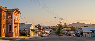
Bowraville is a small town in the Mid North Coast hinterland of New South Wales, Australia in the Nambucca Valley. The town is known for tourism with attractions such as a folk museum, a war museum, a historic theatre, and other historic buildings.

<span class="mw-page-title-main">Mid North Coast</span> Region in New South Wales, Australia

The Mid North Coast is a country region in the north-east of the state of New South Wales, Australia. The region is situated 416km north of Sydney, covers the mid northern coast of the state, beginning from Port Stephens at Hawks Nest to as far north as Woolgoolga, near Coffs Harbour. The region has heaps of beaches and many subtropical national parks and forests as well as rural farmland and logging. Major coastal towns include Coffs Harbour, Forster and Port Macquarie. The Mid North Coast is a popular destination for camping or resorts and surfing, with coastal and hinterland tracks.

<span class="mw-page-title-main">Pacific Motorway (Brisbane–Brunswick Heads)</span> Motorway in New South Wales and Queensland

The Pacific Motorway is a motorway in Australia between Brisbane, Queensland, and Brunswick Heads, New South Wales, through the New South Wales–Queensland border at Tweed Heads.

<span class="mw-page-title-main">Waterfall Way</span>

Waterfall Way is a 170-kilometre (110 mi) country road in the Northern Tablelands region of New South Wales, Australia, linking Raleigh on the state's North Coast to Armidale. The route passes through some of New South Wales' most scenic countryside and has become well known as its best and Australia's third most beautiful tourist drive. Seven national parks, of which three are listed as World Heritage Areas by UNESCO and form part of the Gondwana Rainforests of Australia, are located on or close to the route. Dorrigo National Park encompasses the waterfalls that give the route its name.

<span class="mw-page-title-main">Bucketts Way</span> Road in New South Wales, Australia

(The) Bucketts Way is a 151-kilometre (94 mi) rural road that links Gloucester to Taree and Raymond Terrace, in New South Wales, Australia. A former alignment of Pacific Highway, it was later named after the Bucketts Mountains, a prominent mountain range near Gloucester. The entire route is designated as Tourist Route 2.

<span class="mw-page-title-main">Urunga, New South Wales</span> Town in New South Wales, Australia

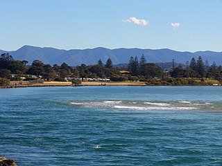
Urunga is a small town located within the Mid North Coast region of New South Wales, Australia, in Bellingen Shire. It is famous for its surf spots. At the 2011 census, Urunga had a population of 3,020. The town is south of Coffs Harbour and Sawtell and north of Nambucca Heads. The place name, Urunga, is derived from the Gumbaynggir word Yurūnga, which is derived from the word for long yurūn in reference to "long white sands".

<span class="mw-page-title-main">Nambucca Heads</span> Town in New South Wales, Australia

Nambucca Heads is a town on the Mid North Coast of New South Wales, Australia in the Nambucca Valley. It is located on a ridge, north of the estuary of the Nambucca River near the Pacific Highway. Its 2021 population was 6,675, including 5,226 (78.3%) Australian-born persons and 672 indigenous persons.

<span class="mw-page-title-main">Bellingen Shire</span> Local government area in New South Wales, Australia

Bellingen Shire is a local government area in the Mid North Coast region of New South Wales, Australia. The Shire is located adjacent to the Pacific Highway, Waterfall Way and the North Coast railway line.

<span class="mw-page-title-main">Scotts Head, New South Wales</span> Suburb of Nambucca Valley Council, New South Wales, Australia

Scotts Head is a coastal village of the Nambucca Valley local government area in the Mid North Coast region of New South Wales, Australia. Located on the coast of the Pacific Ocean, approximately 10 kilometres (6 mi) from the Pacific Highway and 480 kilometres (300 mi) from Sydney, it stretches southwards from just south of the mouth of the Nambucca River to the town of Scotts Head in the south.

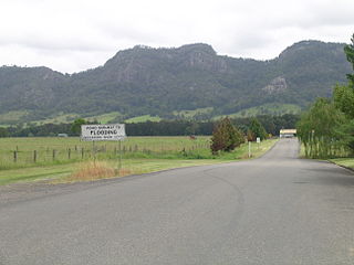
Warrell Creek is a locality on the Mid North Coast of New South Wales, Australia. It is situated on the Pacific Highway 8 km south of the township of Macksville, 15.5 km west of the coastal village of Scotts Head and 11 km north of the Eungai locality.

The Gumbaynggirr people, also rendered Kumbainggar, Gumbangeri and other variant spellings, are an Aboriginal Australian people of the Mid North Coast of New South Wales. Gumbathagang was a probable clan or sub-group. The traditional lands of the Gumbaynggirr nation stretch from Tabbimoble Yamba-Clarence River to Ngambaa-Stuarts Point, SWR- Macleay to Guyra and to Oban.

<span class="mw-page-title-main">Electoral district of Oxley</span>

Oxley is an electoral district of the Legislative Assembly in the Australian state of New South Wales.

The Macleay Valley Way is a road in the Mid North Coast region of New South Wales that connects the Pacific Highway to Kempsey and Frederickton. It runs along a former section of the Pacific Highway that was bypassed by a newer alignment between 2013 and 2016.

Big River Way is a road in the Northern Rivers region of New South Wales that connects the Pacific Highway to the city of Grafton. It runs along a former section of the Pacific Highway that was bypassed by a newer alignment in 2020.

Solitary Islands Way is a road in the Mid North Coast region of New South Wales, located north of the city of Coffs Harbour. It links the towns of Woolgoolga and Corindi Beach to the Pacific Highway. It consists of a mix of newly constructed roads, pre-existing Council-owned roads and former sections of the highway that were bypassed by new alignments in 2013 and 2017.

References

  1. 1 2 3 Google (10 December 2020). "Pacific Hwy, Congarinni NSW 2447 to Giinagay Way, Raleigh NSW 2454" (Map). Google Maps . Google. Retrieved 10 December 2020.
  2. 1 2 3 "Nambucca Shire Council - Roads Act 1993 - Naming of Roads (28)" (PDF). Government Gazette of the State of New South Wales . 24 February 2017. p. 537. Retrieved 10 December 2020.
  3. 1 2 "Bellingen Shire Council - Roads Regulation 2008- Naming of Roads (80)" (PDF). Government Gazette of the State of New South Wales . 14 July 2017. p. 4150-4151. Retrieved 10 December 2020.
  4. 1 2 3 "Indigenous name suggested for 'old' Pacific Hwy". The Coffs Coast Advocate. 12 February 2015. Retrieved 9 December 2020.
  5. 1 2 "Residents concerned about their loss of local identity". Nambucca Guardian. 6 September 2017. Archived from the original on 13 November 2020. Retrieved 9 December 2020.
  6. Ramsey, Britt (21 July 2016). "Nambucca Heads to Urunga bypass open" . Retrieved 22 July 2016.
  7. "New speed limit between Nambucca Heads and Urunga". Nambucca Guardian. 7 February 2017. Archived from the original on 12 November 2020. Retrieved 9 December 2020.
  8. "Warrell Creek to Nambucca Highway upgrade completed". Nambucca Guardian. 29 June 2018. Retrieved 29 June 2018.