The Murray River is a river in south-eastern Australia. It is Australia's longest river at 2,508 km (1,558 mi) extent. Its tributaries include five of the next six longest rivers of Australia. Together with that of the Murray, the catchments of these rivers form the Murray–Darling basin, which covers about one-seventh the area of Australia. It is widely considered Australia's most important irrigated region.

Sturt Highway is an Australian national highway in New South Wales, Victoria, and South Australia. It is an important road link for the transport of passengers and freight between Sydney and Adelaide and the regions situated adjacent to the route.

Cobb Highway is a state highway in the western Riverina and the far western regions of New South Wales, with a short section in Victoria, Australia.
The Murray Valley Highway is a 663-kilometre (412 mi) state highway located in Victoria and New South Wales, Australia. The popular tourist route mostly follows the southern bank of the Murray River and effectively acts as the northernmost highway in Victoria. For all but the western end's last three kilometres, the route is designated as B400.

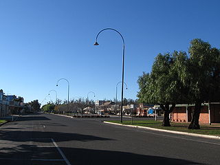
Yarrawonga is a town in the Shire of Moira local government area in the Australian state of Victoria. The town is situated on the south bank of the Murray River, the border between Victoria and New South Wales, and is located approximately 265 kilometres (165 mi) north-east of the state capital, Melbourne. Yarrawonga's twin town of Mulwala is on the other side of the Murray River. At the 2016 census, Yarrawonga had a population of 7,930.

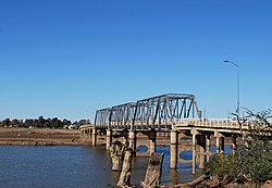
Lake Mulwala, a man–made reservoir created through the construction of the Yarrawonga Weir across the Murray River, is located between Bundalong and Yarrawonga in Hume region of Victoria and Mulwala in the Riverina region of New South Wales, in eastern Australia. The weir was constructed in 1939 to provide water for irrigation of the surrounding district. The weir also serves as a crossing of the Murray between the two towns; in addition to the crossing located via the Mulwala Bridge.

Riverina Highway is a 220-kilometre (140 mi)-long state highway located in the Riverina region of New South Wales, Australia. The road was constructed over several decades with final asphalt concrete sealing completed during the 1960s.

Barooga is a border town in the Riverina region of New South Wales, Australia, located in the Berrigan Shire local government area. It is situated just north of the Murray River which forms the border with Victoria. Barooga's population at the 2016 census was 1,817.

Mulwala is a town in the Federation Council local government area in the Riverina district of New South Wales, Australia. The town is situated on Lake Mulwala, an artificial lake formed by the damming of the Murray River. At the 2006 census, Mulwala had a population of 1,986 people. The town's name is derived from an aboriginal word for 'rain'.

Abbotsford Bridge is a steel Allan truss-type road bridge that carries the Silver City Highway across the Murray River, between Curlwaa in New South Wales, and Yelta in Victoria, Australia. It is the only remaining steel truss bridge with a lift span that crosses the Murray. Opened in 1928, the bridge was built by the NSW Department of Public Works and was designed by Percy Allan. It was the second last vertical-lift bridge to be built over the river, the last being the Nyah Bridge, which opened in 1941.
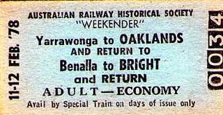
The Oaklands railway line is a freight-only railway line in north-eastern Victoria, Australia. The line branches from the main North East railway at Benalla station and runs across the Victoria-New South Wales border to the town of Oaklands, New South Wales.

The Wymah Ferry is a cable ferry across the upper reach of Lake Hume, on the Murray River and on the border between the Australian states of New South Wales and Victoria. The ferry crosses from the community of Wymah on the New South Wales side of the river, to Granya, and is approximately 35 kilometres (22 mi) east of Albury.
The railway to Stony Crossing, New South Wales, was sanctioned as part of the Border Railways Act 1922. It was often referred to as the Gonn Crossing to Stony Crossing railway, although it originated at Kerang, Victoria and served Murrabit, before running into New South Wales at Gonn Crossing on the Murray River.

The Bethanga Bridge is a steel truss road bridge that carries the Riverina Highway across Lake Hume, an artificial lake on the Murray River in Australia. The dual heritage-listed bridge crosses the border between the Australian states of New South Wales and Victoria, linking the Victorian towns of Bellbridge and Bethanga with the regional New South Wales city of Albury.

The Murray River road and railway bridge is a heritage-listed railway and former road bridge that carries the Tocumwal railway line across the Murray River at Tocumwal in the Berrigan Shire local government area of New South Wales, Australia. It is also known as the Tocumwal Road and Rail Bridge over Murray River. The property is owned by RailCorp. It was added to the New South Wales State Heritage Register on 2 April 1999.

The Murray River bridge is a heritage-listed road bridge that carries Main Road across the Murray River located at Barham in the Murray River Council local government area of New South Wales, Australia. It was designed by Department of Public Works and built in 1904 by John Monash. The bridge is also known as the Barham Bridge over Murray River and the Barham bridge. The bridge is owned by the Murray River Council and was added to the New South Wales State Heritage Register on 20 June 2000.

The Murray River road bridge is a heritage-listed road bridge that carries Swan Hill Road across the Murray River, on the border between New South Wales and Victoria, Australia. The bridge connects Murray Downs in New South Wales with McCallum Street in Swan Hill, Victoria. The bridge was built in 1896 and is owned by Transport for NSW. The bridge is also called the Swan Hill Bridge and the Swan Hill-Murray River Road Bridge. It was added to the New South Wales State Heritage Register on 20 June 2000.

The Tooleybuc Bridge is a dual heritage-listed road bridge that carries Tooleybuc Road across the Murray River, located in Tooleybuc, New South Wales, Australia. It was built in 1925. The bridge is owned by the Transport for NSW, and is also called the Tooleybuc Bridge over Murray River. The bridge was added to the New South Wales State Heritage Register on 20 June 2000 and the Victorian Heritage Register on 10 July 2008.

The George Chaffey Bridge is a road bridge in Australia that carries the Sturt Highway across the Murray River from Buronga to Mildura.