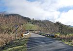
South Australia


As the ferries are registered as boats, each one has a name, usually named after a waterbird. As of December 2017, the ferry names are: [2]
The Murray River in south-eastern Australia has been a significant barrier to land-based travel and trade. This article lists and briefly describes all of the recognised crossing points. Many of these had also developed as river ports for transport of goods along the Murray. Now almost every significant town along the river has a bridge or vehicle-carrying cable ferry nearby.
The crossings are listed in order starting from the Murray Mouth and proceeding upstream.
As the ferries are registered as boats, each one has a name, usually named after a waterbird. As of December 2017, the ferry names are: [2]
The south bank of the river forms the border between these two states and former colonies, so in many cases there is a town on each side of the river. If two towns are named in this list, the Victorian one is first for clarity and consistency.
Most of the bridges downstream of Echuca are liftspan bridges to enable paddlesteamer traffic to pass underneath even in times of high water flow.
The Hume, Newell and Sturt Highway bridges are owned and managed by the Federal Government. The others are the responsibility of New South Wales and Victoria.
| Image | Crossing | Coordinates | Location | Built | Description | Notes |
|---|---|---|---|---|---|---|
 | Abbotsford Bridge | 34°06′50″S141°59′17″E / 34.11389°S 141.98806°E | Yelta to Curlwaa | 1928 | 235 metres (771 ft) long, single lane lift bridge | |
 | George Chaffey Bridge | 34°10′59″S142°10′24″E / 34.18306°S 142.17333°E | Mildura to Buronga | 1985 | 331 metres (1,086 ft) long, 9.8 metres (32.2 ft) wide bridge carrying the Sturt Highway | |
 | Robinvale-Euston Bridge | 34°34′40″S142°46′3″E / 34.57778°S 142.76750°E | Robinvale to Euston | 2006 | Replaced a single-lane lift-span road/rail bridge that was opened in 1927 as part of the abandoned Lette railway line.[ permanent dead link ]. | |
 | Tooleybuc Bridge | 35°01′49″S143°20′7″E / 35.03028°S 143.33528°E | Piangil to Tooleybuc | 1925 | timber and steel truss, single-lane restriction on lift span | |
 | Nyah Bridge | 35°10′22″S143°23′30″E / 35.17278°S 143.39167°E | Nyah to Koraleigh | 1941 | 104 metres (341.2 ft), central lift span | |
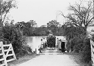
 | Speewa Ferry | 35°12′49″S143°30′31″E / 35.21361°S 143.50861°E | Speewa | Two-car capacity, 8 tonne (8.8 t) load limit. Upstream is a private ferry to Beveridge Island (part of Victoria); it crosses a Little Murray anabranch, but that is now the main navigable channel. | ||
 | Swan Hill Bridge | 35°20′16″S143°33′46″E / 35.33778°S 143.56278°E | Swan Hill | 1896 | Two lanes except central lift span; 116 metres (380.6 ft) | |
 | Gonn Crossing Bridge | 35°30′13″S143°57′24″E / 35.50361°S 143.95667°E | Murrabit to Ballbank | 1926 | 103 metres (338 ft) Lift-span road/rail bridge, opened as part of the Stony Crossing railway line; road only since the railway closed in 1964. | |
 | Barham Bridge | 35°37′50″S144°07′29″E / 35.63056°S 144.12472°E | Koondrook to Barham | 1904 | liftspan bridge, 99 metres (325 ft) | |
| Dhungala Bridge | 36°06′44″S144°44′38″E / 36.11222°S 144.74389°E | Echuca to Moama | 2022 | 622 metres (2,041 ft) [3] Cobb Highway crossing | ||
 | Echuca-Moama Bridge (road) | 36°07′19″S144°45′13″E / 36.12194°S 144.75361°E | 1879 | built as joint road/rail bridge, bypassed in 2022, local traffic only | ||
 | Echuca-Moama Bridge (rail) | 36°07′19″S144°45′13″E / 36.12194°S 144.75361°E | 1989 | rail | ||
 | Barmah Bridge | 36°01′8″S144°57′19″E / 36.01889°S 144.95528°E | Barmah | 1966 | 168 metres (551.2 ft) replaced ferry [4] | |
 | Tocumwal Bridge | 35°48′50″S145°33′24″E / 35.81389°S 145.55667°E | Tocumwal | 1895 | originally a road/rail bridge | |
 | Edward Hillson Bridge | 35°48′47″S145°33′32″E / 35.81306°S 145.55889°E | 1987 | Newell Highway 212 metres (695.5 ft) long, 12 metres (39.4 ft) wide | ||
 | Old Cobram-Barooga Bridge | 35°54′57″S145°40′9″E / 35.91583°S 145.66917°E | Cobram to Barooga | 1902 | Old liftspan timber truss bridge (now pedestrian only) | |
 | Cobram-Barooga Bridge | 35°54′58″S145°40′9″E / 35.91611°S 145.66917°E | 2006 | New concrete bridge built immediately upstream of the old bridge | ||
 | Yarrawonga Weir | 36°00′31″S145°59′57″E / 36.00861°S 145.99917°E | Yarrawonga to Mulwala | 1939 | Weir Road, one lane along the weir wall - originally designated as a stock route | |
 | Yarrawonga Rail Bridge | 36°00′29″S145°59′59″E / 36.00806°S 145.99972°E | 1989 | railway bridge, replaced earlier wooden bridge and earthen embankment | ||
 | Mulwala Bridge | 36°00′20″S146°00′18″E / 36.00556°S 146.00500°E | 1924 | Crosses Lake Mulwala, 488 metres (1,601 ft) | ||
 | John Foord Bridge | 36°00′25″S146°23′43″E / 36.00694°S 146.39528°E | Wahgunyah to Corowa | 1892 | retained for local traffic | |
 | Federation Bridge | 35°59′8″S146°24′40″E / 35.98556°S 146.41111°E | 2005 | Two lanes wide and 195 metres (639.8 ft) long, with a 95 metres (311.7 ft) approach bridge on the NSW side. | ||
 | John Conway Bourke Bridge | 35°59′37″S146°37′15″E / 35.99361°S 146.62083°E | Howlong | 2001 | Commemorates the first carrier of mail from Sydney in 1838 to what would later be called Melbourne [5] | |
 | Lincoln Causeway/Union Bridge | 36°05′29″S146°54′23″E / 36.091318°S 146.906524°E | Wodonga to Albury | 1961 (though first bridge opened 1861 [6] ) | 4 lanes, 92 metres (301.8 ft) long, widened 1990 | |
 | Albury-Wodonga Railway Bridge | 36°05′59″S146°54′34″E / 36.099738°S 146.909314°E | 1888 | Originally double track - one Broad gauge plus one Standard gauge. Broad gauge track disconnected following conversion of the North East Victorian broad gauge line to standard gauge in 2010. | ||
 | Spirit of Progress Bridge | 36°06′02″S146°54′34″E / 36.100518°S 146.909486°E | 2006 | New Hume Highway bridge, named fafter the Spirit of Progress train. [7] | ||
 | Island Road Bridge | 36°04′42″S146°57′20″E / 36.078262°S 146.955684°E | Thurgoona to the Island | |||
 | Heywood Bridge | 36°05′57″S147°01′19″E / 36.09917°S 147.02194°E | Hume Dam to Bonegilla | 1984 | 124 metres (406.8 ft) long. Between Albury and here there is a bridge near the airport, to Bonegilla Island. | |
 | Bonegilla Bridge | 36°06′26″S147°01′56″E / 36.10722°S 147.03222°E | Hume Dam to Bonegilla | 1941 | The Hume Weir wall, now closed to motorised traffic. single lane, 91 metres (298.6 ft) | |
 | Bethanga Bridge | 36°05′25″S147°03′31″E / 36.09028°S 147.05861°E | Bellbridge | 1930 | on the Riverina Highway across Lake Hume | |
 | Wymah Ferry | 36°02′23″S147°15′56″E / 36.03972°S 147.26556°E | Wymah | upstream end of Lake Hume, 2-car capacity, 11 tonne (12.1 t) load limit | ||
 | Jingellic Bridge | 35°55′53″S147°42′5″E / 35.93139°S 147.70139°E | Jingellic | 1959 | 156 metres (511.8 ft) | |
 | Tintaldra Bridge | 36°2′44″S147°55′56″E / 36.04556°S 147.93222°E | Tintaldra | 1959 | steel truss bridge 185 metres (607 ft) | |
 | Towong Bridge | 36°7′26″S147°59′46″E / 36.12389°S 147.99611°E | Towong | 1938 | 61 metres (200.1 ft) long | |
 | Bringenbrong Bridge | 36°10′8″S148°01′31″E / 36.16889°S 148.02528°E | Bringenbrong | 1961 | 87 metres (285.4 ft) long, near Corryong on the Alpine Way | |
 | Indi Bridge | 36°14′46″S148°02′5″E / 36.24611°S 148.03472°E | 1961 | Connects the Indi homestead in NSW to the Upper Murray Road. Steel girder, with concrete piles and a concrete deck. Single lane, 3.7 metres (12 ft) wide. [8] | ||
 | Biggara Bridge | 36°17′46″S148°02′17″E / 36.29611°S 148.03806°E | Biggara | 1951 | ||
| Tom Groggin Bridge | 36°31′20″S148°08′13″E / 36.522085°S 148.136998°E | Tom Groggin | Private bridges to Tom Groggin Station: low level for vehicles; higher-level suspension bridge for pedestrians when the other is flooded. |
![]() Media related to Bridges over the Murray River at Wikimedia Commons
Media related to Bridges over the Murray River at Wikimedia Commons
![]() Media related to Cable ferries on the Murray River at Wikimedia Commons
Media related to Cable ferries on the Murray River at Wikimedia Commons

The Murray River is a river in Southeastern Australia. It is Australia's longest river at 2,508 km (1,558 mi) extent. Its tributaries include five of the next six longest rivers of Australia. Together with that of the Murray, the catchments of these rivers form the Murray–Darling basin, which covers about one-seventh the area of Australia. It is widely considered Australia's most important irrigated region.

Albury is a major regional city in New South Wales, Australia. It is located on the Hume Highway and the northern side of the Murray River. Albury is the seat of local government for the council area which also bears the city's name – the City of Albury. It is on the Victoria–New South Wales border.

Hume Dam, formerly the Hume Weir, is a major dam across the Murray River downstream of its junction with the Mitta River in the Riverina region of New South Wales, Australia. The dam's purpose includes flood mitigation, hydro-power, irrigation, water supply and conservation. The impounded reservoir is called Lake Hume, formerly the Hume Reservoir. It is a gated concrete gravity dam with four earth embankments and twenty-nine vertical undershot gated concrete overflow spillways.

Sturt Highway is an Australian national highway in New South Wales, Victoria, and South Australia. It is an important road link for the transport of passengers and freight between Sydney and Adelaide and the regions along the route.

The Riverina is an agricultural region of south-western New South Wales, Australia. The Riverina is distinguished from other Australian regions by the combination of flat plains, warm to hot climate and an ample supply of water for irrigation. This combination has allowed the Riverina to develop into one of the most productive and agriculturally diverse areas of Australia. Bordered on the south by the state of Victoria and on the east by the Great Dividing Range, the Riverina covers those areas of New South Wales in the Murray and Murrumbidgee drainage zones to their confluence in the west.

The Loddon River, an inland river of the north–central catchment, part of the Murray-Darling basin, is located in the lower Riverina bioregion and Central Highlands and Loddon Mallee regions of the Australian state of Victoria. The headwaters of the Loddon River rise on the northern slopes of the Great Dividing Range east of Daylesford and descend to flow north into the Little Murray River, near Swan Hill. The river is impounded by the Cairn Curran and Laanecoorie reservoirs.

Swan Hill is a city in the northwest of Victoria, Australia on the Murray Valley Highway and on the south bank of the Murray River, downstream from the junction of the Loddon River. At 2021 census, Swan Hill had a population of 11,508.

Wisemans Ferry is a cable ferry across the Hawkesbury River in New South Wales, Australia. The ferry operates from the eponymous community of Wisemans Ferry on the south bank, to a point on the north bank downstream of the Hawkesbury River's confluence with the Macdonald River, connecting with the old Great North Road. The crossing has remained in use on its current site since 1829, making it the oldest ferry crossing still in operation in New South Wales, and possibly in Australia.

Blanchetown is a small township in South Australia, on the (west) bank of the Murray River, 130 kilometres (81 mi) northeast of Adelaide. The Blanchetown Bridge is the westernmost of the four crossings of the Sturt Highway over the Murray River. During the nineteenth century it was an important transportation centre on the lower Murray. In the early 21st century, Blanchetown has been described as "a strange mixture of historic buildings and temporary shacks built by holidaymakers on the banks of the river". Blanchetown is widely regarded as the entrance to the Riverland district.
The 1956 Murray River flood involved the rising of waters in the Murray River and flooding of many towns in New South Wales, Victoria and South Australia. The flood was and still is considered the biggest flood in the recorded history of the Murray and described as "the greatest catastrophe in South Australia's history", although few lives were lost.

The Wymah Ferry is a cable ferry across the upper reach of Lake Hume, on the Murray River and on the border between the Australian states of New South Wales and Victoria. The ferry crosses from the community of Wymah on the New South Wales side of the river, to Granya, and is approximately 35 kilometres (22 mi) east of Albury.
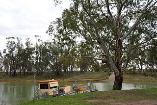
The Speewa Ferry is a cable ferry across the Murray River on the border between the Australian states of New South Wales and Victoria. The ferry is located in the community of Speewa, Victoria, approximately 20 kilometres (12 mi) north of Swan Hill, off the road between Swan Hill and Nyah.

The Bethanga Bridge is a steel truss road bridge that carries the Riverina Highway across Lake Hume, an artificial lake on the Murray River in Australia. The dual heritage-listed bridge crosses the border between the Australian states of New South Wales and Victoria, linking the Victorian towns of Bellbridge and Bethanga with the regional New South Wales city of Albury.
Bowhill is a locality in South Australia. A settlement is located inside a bend on the left (eastern/southern) bank of the Murray River between Mannum and Swan Reach. It is predominantly shacks built facing the river bank. The settlement is in the Mid Murray Council area, but most of the locality is located away from the river and within in the District Council of Karoonda East Murray, including the Lowan Conservation Park.
Purnong or Purnong Landing is the location of a cable ferry across the Murray River upstream of Mannum. The town is on the cliffs above the left (eastern) bank of the river. It is 32 kilometres (20 mi) by road from Mannum on the west side of the Murray, and 40 kilometres (25 mi) on the east side.

The Murray River bridge is a heritage-listed road bridge that carries Main Road across the Murray River located at Barham in the Murray River Council local government area of New South Wales, Australia. It was designed by Department of Public Works and built in 1904 by John Monash. The bridge is also known as the Barham Bridge over Murray River and the Barham bridge. The bridge is owned by the Murray River Council and was added to the New South Wales State Heritage Register on 20 June 2000.

The Murray River road bridge is a heritage-listed road bridge that carries Swan Hill Road across the Murray River, on the border between New South Wales and Victoria, Australia. The bridge connects Murray Downs in New South Wales with McCallum Street in Swan Hill, Victoria. The bridge was built in 1896 and is owned by Transport for NSW. The bridge is also called the Swan Hill Bridge and the Swan Hill-Murray River Road Bridge. It was added to the New South Wales State Heritage Register on 20 June 2000.

The Tooleybuc Bridge is a dual heritage-listed road bridge that carries Tooleybuc Road across the Murray River, located in Tooleybuc, New South Wales, Australia. It was built in 1925. The bridge is owned by the Transport for NSW, and is also called the Tooleybuc Bridge over Murray River. The bridge was added to the New South Wales State Heritage Register on 20 June 2000 and the Victorian Heritage Register on 10 July 2008.

The PS Gem is a retired side-wheel paddle steamer that was first launched in 1876 on the Murray River at Moama, New South Wales. She operated as a cargo and passenger steamer, regularly cruising between Morgan and Mildura. The Gem operated as a tourist passenger vessel during the 1930s and 1940s, and was retired in the early 1950s. In 1962 the Gem was sold to the then Swan Hill Folk Museum, where it would become a static display and historic monument.