Lake Albert (South Australia)

Last updated

Lake Albert
MeningieLakeAlbert.JPG
Lake Albert seen from Meningie
Australia South Australia relief location map.png
Red pog.svg
Lake Albert
Location South Australia
Coordinates 35°38′S139°17′E / 35.633°S 139.283°E / -35.633; 139.283 Coordinates: 35°38′S139°17′E / 35.633°S 139.283°E / -35.633; 139.283 [1]
Native nameYarli  (Ngarrindjeri) [2]
Etymology Prince Albert of Saxe-Coburg and Gotha
Part of Murray–Darling basin
Basin  countriesAustralia
Managing agency Department of Environment and Water
DesignationRamsar/DIWA wetlands (part) [1]
Surface area168 square kilometres (65 sq mi) [1]
Islands Bascombe Island [3]
Settlements Meningie, Narrung
Official nameThe Coorong, Lake Alexandrina & Albert Wetland
Designated1 November 1985
Reference no.321 [4]

Lake Albert, also known by its Ngarrindjeri name, Yarli, is a notionally fresh water lake near the mouth of the Murray River in South Australia. It is filled by water flowing in from the larger Lake Alexandrina at its mouth near Narrung. It is separated on the south by the Narrung Peninsula from the salt-water Coorong. The only major town on the lake is Meningie. Lakes Alexandrina and Albert are together known as the Lower Lakes.

Contents

Naming of lake

The lake was named after Prince Albert, the Consort of Queen Victoria, by George Gawler, the Governor of South Australia. [5]

Tourism

Two pelicans on Lake Albert at Meningie Lake-Albert-03.jpg
Two pelicans on Lake Albert at Meningie

Lake Albert is visited regularly by people travelling to and from Melbourne, the Limestone Coast, the Coorong National Park, Tailem Bend, Murray Bridge, and Adelaide.[ citation needed ]

Visitors enjoy fishing, camping, bushwalking, 4WD tracks, bird watching and water sports.[ citation needed ]

Water problems

Because there are no significant tributaries and a high evaporation rate, Lake Albert is saltier than Lake Alexandrina. It is also smaller and not as deep, but it is more protected from the elements. In 2008, water levels in Lake Alexandrina and Lake Albert became so low that large quantities of acid sulphate soils started to form. [6] The possibility of flooding the lake with seawater to prevent acidification was raised, and tension remains between South Australia and the upstream states over how to share the dwindling supply of water. [7] To this day the lake remains at significant risk of water loss and high salinity. [8]

Flora and fauna

Birds

Lake Albert supports critically endangered orange-bellied parrots, endangered Australasian bitterns, vulnerable fairy terns, as well as over 1% of the world populations of Cape Barren geese, Australian shelducks, great cormorants and sharp-tailed sandpipers. [9]

Protected area status

Australian government

Lake Albert is part of the wetland complex known as the Coorong and Lakes Alexandrina and Albert Wetland which is listed as a Ramsar site. The wetland is also appears in the non-statutory list known as A Directory of Important Wetlands in Australia . [10] [11]

Non-statutory arrangements

Lake Albert is included within the boundary of the Lakes Alexandrina and Albert Important Bird Area which is an area considered by BirdLife International to be a place of ‘international significance for the conservation of birds and other biodiversity.’ [9] [12]

Administrative status

The full extent of Lake Albert was gazetted as a ‘rural locality’ on 8 May 2014 along with Lake Alexandrina. The boundary of the locality of ‘Lake Albert’ with the rural locality of Lake Alexandrina occurs at the alignment of Poltalloch Road within the locality of Poltalloch on the northern side of the Albert Channel which connects both lakes. [2] [13] [14] The locality was included in the 2016 census and was found to have no people living within its boundaries. [15] It also shares the postcode of "5259" with the adjoining localities of Narrung and Poltalloch. [2]

See also

Related Research Articles

Coorong National Park Protected area in South Australia

Coorong National Park is a protected area located in South Australia about 156 kilometres (97 mi) south-east of Adelaide, that predominantly covers a coastal lagoon ecosystem officially known as The Coorong and the Younghusband Peninsula on the Coorong's southern side. The western end of the Coorong lagoon is at the Murray Mouth near Hindmarsh Island and the Sir Richard Peninsula, and it extends about 130 kilometres (81 mi) south-eastwards. Road access is from Meningie. The beach on the coastal side of the peninsula, the longest in Australia, is also commonly called The Coorong.

Lake Alexandrina (South Australia)

Lake Alexandrina is a coastal freshwater lake located between the Fleurieu and Kangaroo Island and Murray and Mallee regions of South Australia, about 100 kilometres (62 mi) south-east of Adelaide. The lake adjoins the smaller Lake Albert and a coastal lagoon called The Coorong to its southeast, before draining into the Great Australian Bight via a short, narrow opening known as Murray Mouth.

Murray Mouth

Murray Mouth is the point at which the River Murray meets the Southern Ocean. The Murray Mouth's location is changeable. Historical records show that the channel out to sea moves along the sand dunes over time. At times of greater river flow and rough seas, the two bodies of water would erode the sand dunes to create a new channel leaving the old one to silt and disappear.

Meningie, South Australia Town in South Australia

Meningie is a town on the south-east side of Lake Albert in South Australia. It is on the Princes Highway near The Coorong and was surveyed in 1866. At the 2016 census, the locality of Meningie had a population of 1118 with a median age of 51 while its town centre had a population of 852.

Coorong, South Australia Suburb of Coorong, Kingston, (north to south), South Australia

Coorong is a locality in the Australian state of South Australia which is associated with the lagoon known as the Coorong in the south-east of the state and which overlooks the continental coastline from the mouth of the Murray River about 80 kilometres south-east of the state capital of Adelaide to the immediate north of the town of Kingston SE extending for a distance of at least 140 kilometres (87 mi).

Wellington Weir Proposed dam in Australia

Wellington Weir was a weir proposed for the River Murray several kilometres south of the town of Wellington, South Australia, immediately upstream from where the river enters Lake Alexandrina.

Coorong District Council Local government area in South Australia

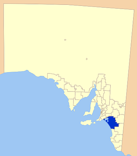
Coorong District Council is a local government area in South Australia located between the River Murray and the Limestone Coast region. The district cover mostly rural areas with small townships, as well as part of the Coorong National Park.

Clayton Bay Town in South Australia

Clayton Bay is a town in South Australia located on Lake Alexandrina and the Lower Lakes, north of the north-east tip of Hindmarsh Island about 87 kilometres (54 mi) by road from Adelaide and 12 kilometres (7 mi) upstream from Goolwa and the Murray Mouth.

Narrung, South Australia Town in South Australia

Narrung is a town and locality in the Australian state of South Australia. It is situated at the northern extent of the Narrung Peninsula, which separates The Coorong from Lake Albert adjacent to The Narrows which separates Lake Albert from the larger Lake Alexandrina. The area of Narrung includes the Aboriginal (Ngarrindjeri) community of Raukkan.

Mud Islands Game Reserve Protected area in South Australia

Mud Islands Game Reserve is a protected area in South Australia covering ten islands at the southern side of Lake Alexandrina about 19 kilometres south-east of Goolwa. The game reserve is described as providing ‘an ideal habitat for water birds, particularly waterfowl’ and that ‘duck shooting is permitted during open season.’ Since 2000, the game reserve has been located within the boundaries of the gazetted locality, Coorong.

Point Sturt Town in South Australia

Point Sturt is a locality in the Australian state of South Australia located on the Sturt Peninsula on the west side of Lake Alexandrina about 71 kilometres (44 mi) south-east of the state capital of Adelaide and about 17 kilometres (11 mi) east of the municipal seat of Goolwa.

Poltalloch, South Australia Suburb of Coorong District Council, South Australia

Poltalloch is a locality in the Australian state of South Australia located on land between the water bodies of Lake Alexandrina and Lake Albert about 87 kilometres south-east of the state capital of Adelaide.

County of Russell Cadastral in South Australia

The County of Russell is one of the 49 cadastral counties of South Australia. It was proclaimed in 1842 by Governor George Grey and named for Lord John Russell, who was involved with the early development of the (British) South Australian colony when he was Secretary of State for War and the Colonies. It covers a portion of the state bounded to the west by the eastern half of Lake Alexandrina and the section of the Murray River extending to Bowhill in the north and bounded to the south by the coastline adjoining the Coorong coastal lagoon and fully surrounds Lake Albert which is excluded from its extent. This includes the north western quarter of the contemporary local government area of Coorong District Council.

Goolwa North, South Australia Suburb of Alexandrina Council, South Australia

Goolwa North is a locality in the Australian state of South Australia located about 66 kilometres south of the state capital of Adelaide and 2.5 kilometres northeast of the centre of the municipal seat of Goolwa overlooking the following water bodies in the Murray River system - Currency Creek to the north and the channel known as Goolwa or the Lower Murray to the south-east.

Lake Plains, South Australia Suburb of Alexandrina Council, South Australia

Lake Plains is a locality in the Australian state of South Australia located about 64 kilometres south of the Adelaide city centre and 27 kilometres northeast of the centre of Goolwa on the west coastline of Lake Alexandrina.

Tolderol, South Australia Suburb of Alexandrina Council, Rural City of Murray Bridge, South Australia

Tolderol is a locality in the Australian state of South Australia located about 67 kilometres south of the Adelaide city centre, 32 kilometres north-east of the centre of Goolwa and 32 kilometres south-west of the centre of Murray Bridge on the west coastline of Lake Alexandrina.

Lawari Conservation Park Protected area in South Australia

Lawari Conservation Park is a protected area in the Australian state of South Australia in the gazetted locality of Hindmarsh Island located at the eastern end of the island of the same name.

Meningie West, South Australia Suburb of Coorong District Council, South Australia

Meningie West is a locality in the Australian state of South Australia located in the state’s south-east about 99 kilometres (62 mi) south-east of the state capital of Adelaide and about 50 kilometres (31 mi) south-west of the municipal seat in Tailem Bend.

Narrung Peninsula South Australia

Nurrang Peninsula is a peninsula in the Australian state of South Australia located at the south east end of Lake Alexandrina. It is bounded by Lake Alexandrina to the west, by Lake Albert to the north and to the east, and by the Coorong to the south. While the name appears to have been in use since the 19th century and by all levels of government in South Australia, the name was not listed in the state government's official list of placenames until January 2020. Its extent is within the localities of Meningie West and Narrung.

Mundoo Island, South Australia Suburb of Alexandrina Council, South Australia

Mundoo Island is a locality in the Australian state of South Australia located on Mundoo Island and some adjoining water at the southern end of Lake Alexandrina about 87 kilometres (54 mi) south-east of the state capital of Adelaide.

References

  1. 1 2 3 Morelli, J (1995). "Search result for 'The Coorong, Lake Alexandrina & Lake Albert – SA063'". Australian Wetland Database. Australian government. Retrieved 5 January 2018.
  2. 1 2 3 "Search result for 'Lake Albert, Locb' with the following datasets selected - 'Suburbs and Localities', 'Counties', 'Hundreds', 'Local Government Areas', "Postcodes', 'SA Government Regions' and 'Gazetteer'". Location SA Map viewer. Government of South Australia. Retrieved 9 April 2019.
  3. Boating Industry Association of South Australia (BIA); South Australia. Department for Environment and Heritage (2005), South Australia's waters an atlas & guide, Boating Industry Association of South Australia, p. 31, ISBN   978-1-86254-680-6
  4. "The Coorong, Lake Alexandrina & Albert Wetland". Ramsar Sites Information Service. Retrieved 25 April 2018.
  5. "Late Shipwreck and Murders at Encounter Bay. FIRST Report of MAJOR O'HALLORAN, Commissioner of Police, to His EXCELLENCY the GOVERNOR". Southern Australian . Adelaide. 11 September 1840. p. 3. Retrieved 15 June 2014 via National Library of Australia. the shores of Lake Albert, named by your Excellency after her Majesty's Royal Consort. It is a fine body of water to the South of Lake Alexandrina, and united to it by a narrow channel.
  6. "Catalyst – Fire, Flood and Acid Mud" . Retrieved 7 May 2008.
  7. "Now a dust bowl where once was a lake". The Australian. 7 March 2009. Archived from the original on 13 September 2012.
  8. "South Australia seeks more Murray River flow from upstream states to fight Lake Albert salinity". ABC Online. 2 September 2014.
  9. 1 2 "Important Bird Areas factsheet: Lakes Alexandrina and Albert". BirdLife International. Retrieved 19 January 2015.
  10. "Coorong and Lakes Alexandrina and Albert Wetland Ramsar site" (PDF). Department of Environment Water and Natural Resources. 28 January 2014. Retrieved 19 January 2015.
  11. "Australian Wetlands Database – Directory Wetland Information Sheet: The Coorong, Lake Alexandrina & Lake Albert – SA063". Commonwealth of Australia, Department of the Environment. 31 May 2005. Retrieved 19 January 2015.
  12. "Sites – Important Bird and Biodiversity Areas (IBAs)". BirdLife International. Retrieved 19 January 2015.
  13. "Creation of the rural localities of Lake Alexandrina and Lake Albert" (PDF). Place name proposals. Government of South Australia. Archived from the original (PDF) on 10 April 2018. Retrieved 9 April 2019.
  14. BURDETT, M. (8 May 2014). "GEOGRAPHICAL NAMES ACT, 1991 Notice to Assign the Boundaries of Places" (PDF). South Australian Government Gazette. Government of South Australia. p. 1587. Retrieved 5 January 2018.
  15. Australian Bureau of Statistics (27 June 2017). "Lake Albert (State Suburb)". 2016 Census QuickStats. Retrieved 10 April 2019. OOjs UI icon edit-ltr-progressive.svg