Barrier Highway

Last updated

Barrier Highway

New South Wales
Highway sign, Yunta, 2017 (01).jpg
Highway sign, Yunta
Location Barrier Hwy.svg
Coordinates
General information
TypeHighway
Length1,012 km (629 mi) [1]
Gazetted August 1928 (NSW, as Main Road 8) [2]
Route number(s) AUS Alphanumeric Route A32.svg A32 (1998/2013–present)
Former
route number
Australian national route 32.svg National Route 32 (1955–1998/2013)
Major junctions
West endAUS Alphanumeric Route B82.svg Horrocks Highway
Giles Corner, South Australia
 
East endAUS Alphanumeric Route A32.svgAUS Alphanumeric Route B71.svg Mitchell Highway
Nyngan, New South Wales
Location(s)
Region Yorke and Mid North, Far North, [3] Far West
Major settlements Saddleworth, Burra, Peterborough, Yunta, Broken Hill, Wilcannia, Cobar
Highway system

Barrier Highway is a highway in South Australia [4] and New South Wales, and is designated part of route A32. The name of the highway is derived from the Barrier Ranges, an area of moderately high ground in the far west of New South Wales, through which the highway traverses.

Contents

Barrier Highway near Cobar Barrier Highway out of Cobar - 7985.jpg
Barrier Highway near Cobar

Route

Barrier Highway branches off Horrocks Highway at Giles Corner, between Riverton and Tarlee and heads northeast, crossing the border into New South Wales and passing through Broken Hill. It continues further east to Wilcannia where it crosses the Darling River, past Cobar to eventually end in Nyngan, where it joins Mitchell Highway. The area traversed by the highway is remote and very sparsely settled.

History

The passing of the Main Roads Act of 1924 [5] through the Parliament of New South Wales provided for the declaration of Main Roads, roads partially funded by the State government through the Main Roads Board, later the Department of Main Roads, and now Transport for NSW. Barrier Highway was declared (as Main Road No. 8) on 8 August 1928, from the intersection with North-Western Highway (today Mitchell Highway) in Nyngan, via Cobar, Willcannia, and Broken Hill, to the border with South Australia; [2] with the passing of the Main Roads (Amendment) Act of 1929 [6] to provide for additional declarations of State Highways and Trunk Roads, this was amended to State Highway 8 in April 1929.

The highway was fully sealed in October 1972. [7]

The passing of the Roads Act of 1993 [8] through the Parliament of New South Wales, updated road classifications and the way they could be declared within New South Wales. Under this act, Barrier Highway today retains its declaration as Highway 8, from Nyngan to the state border with South Australia. [9]

Barrier Highway was signed as National Route 32 across its entire length in 1955. With both states' conversion to their newer alphanumeric systems in 1998 and 2013, its former route number was updated to A32 for the highway within South Australia in 1998, and within New South Wales in 2013. [10]

Major intersections

StateLGA [11] Location [1] [12] km [1] miDestinationsNotes
South Australia Clare and Gilbert Valleys Giles Corner 00.0AUS Alphanumeric Route B82.svg Horrocks Highway (B82)  Tarlee, Auburn Western terminus of highway and route A32
Saddleworth 17.610.9AUS Alphanumeric Route B84.svg Saddleworth Road (B84 east)  Marrabel, Eudunda Concurrency with route B84
18.311.4AUS Alphanumeric Route B84.svg Saddleworth Road (B84 west)  Auburn, Port Wakefield
Goyder Hanson 56.935.4Farrell Flat Road  Farrell Flat, Clare
Burra 71.644.5AUS Alphanumeric Route B64.svg Goyder Highway (B64 east)  Morgan, Waikerie Concurrency with route B64
78.448.7AUS Alphanumeric Route B64.svg Goyder Highway (B64 west)  Spalding, Crystal Brook
Hallett 10263AUS Alphanumeric Route B78.svg Wilkins Highway (B78 west)  Jamestown
Jessie Street (east)  Hallett
Peterborough Ucolta 15697AUS Alphanumeric Route B79.svg Petersburg Road (B79)  Peterborough, Wilmington, Port Augusta
15798 Crystal Brook–Broken Hill railway line
Pastoral Unincorporated Area Yunta 227141Yunta–Waukaringa Road  Waukaringa
Bindarrah339211 Crystal Brook–Broken Hill railway line
Cockburn 373232
State border377234South Australia – New South Wales border
New South Wales Broken Hill Broken Hill 423263Brookfield Avenue, to Silverton Road (northwest)  Silverton
Galena Street (southeast)  Broken Hill
Roundabout
425264 Williams Street (northeast)  Tibooburra
Iodide Street (northwest)  Broken Hill
426265AUS Alphanumeric Route B79.svg Iodide Street (B79 southeast)  Wentworth, Mildura
Argent Street (southwest)  Broken Hill
427265Menindee Road  Menindee
Central Darling Wilcannia 620390White Cliffs Road  White Cliffs
621386West Wilcannia Road (west)  Menindee
West Tilpa Road (east)  Tilpa, Louth, Bourke
Darling River 622386Bridge over river
Central DarlingWilcannia641398AUS Alphanumeric Route B75.svg Cobb Highway (B75)  Ivanhoe, Hay, Echuca
Cobar Cobar 882548AUS Alphanumeric Route B87.svg Kidman Way (B87 north)  Bourke Concurrency with route B87
883549AUS Alphanumeric Route B87.svg Kidman Way (B87 south)  Hillston, Griffith
Bogan Hermidale 947588 Cobar railway line
966600Hermidale-Nymagee Road  Nymagee
Nyngan 1,011628 Cobar railway line
1,012629AUS Alphanumeric Route A32.svgAUS Alphanumeric Route B71.svg Mitchell Highway (A32 southeast, B71 northwest)  Bourke, Charleville, Dubbo, Bathurst Eastern terminus of highway
Route A32 continues southwest along Mitchell Highway
1.000 mi = 1.609 km; 1.000 km = 0.621 mi

See also

Related Research Articles

<span class="mw-page-title-main">Mitchell Highway</span> Highway in Queensland and New South Wales

Mitchell Highway is an outback state highway located in the central and south western regions of Queensland and the northern and central western regions of New South Wales in Australia. The southern part of Mitchell Highway forms part of the National Highway A32 B71 corridor, which stretches from Sydney to Brisbane via Dubbo. Mitchell Highway also forms part of the shortest route between Sydney and Darwin, via Bourke and Mount Isa, making it an important road link for the transport of passengers and freight for regional New South Wales and Queensland. The highway is a part of route Alternative A2 between Augathella and Charleville, route A71 and B71 between Charleville and Nyngan, and part of route A32 between Nyngan and Bathurst.

<span class="mw-page-title-main">Gwydir Highway</span>

Gwydir Highway is a 568-kilometre (353 mi) state highway in northern New South Wales, Australia. The highway was named after the Gwydir River, which in turn was named after a locale in Wales.

<span class="mw-page-title-main">Silver City Highway</span> Highway in New South Wales, Australia

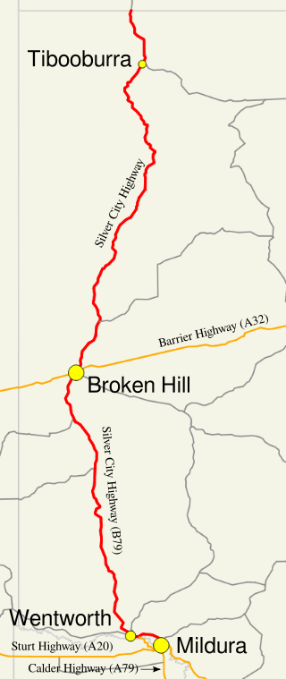
Silver City Highway is a 683-kilometre-long (424 mi) highway that links Buronga, New South Wales to the Queensland border via Wentworth, Broken Hill, and Tibooburra, in the arid Far West region of New South Wales; a short branch also connects to Calder Highway on the Victorian border at Curlwaa. Parts of the highway north of Tibooburra are unsealed. The namesake of the highway is derived from the moniker for Broken Hill - the "Silver City" - which the highway travels through. The highway is designated route B79 from Broken Hill to Buronga.

<span class="mw-page-title-main">Sturt Highway</span> Australian national highway

Sturt Highway is an Australian national highway in New South Wales, Victoria, and South Australia. It is an important road link for the transport of passengers and freight between Sydney and Adelaide and the regions along the route.

<span class="mw-page-title-main">Golden Highway</span> Highway in New South Wales

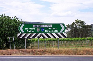
Golden Highway is a 313-kilometre (194 mi) highway, located in the Hunter and Orana regions of New South Wales, Australia. It runs eastwards from Dubbo towards Newcastle on the coast, allowing road transport to avoid travelling over the Blue Mountains to Sydney, and is designated route B84.

<span class="mw-page-title-main">Cobb Highway</span>

Cobb Highway is a state highway in the western Riverina and the far western regions of New South Wales, with a short section in Victoria, Australia, designated part of route B75.

<span class="mw-page-title-main">Kidman Way</span> Highway in New South Wales

Kidman Way is a state rural road in the western Riverina and western region of New South Wales, Australia. The 643-kilometre (400 mi) highway services the Murrumbidgee Irrigation Area and outback communities and links the Newell Highway with the Sturt, Mid-Western, Barrier, Mitchell and Kamilaroi highways. The road is designated route B87 for its entire length, with its northern terminus at Bourke and its southern terminus just north of Jerilderie. Kidman Way is fully sealed and is accessible by two or four-wheel drive.

<span class="mw-page-title-main">Bucketts Way</span> Road in New South Wales, Australia

(The) Bucketts Way is a 151-kilometre (94 mi) rural road that links Gloucester to Taree and Raymond Terrace, in New South Wales, Australia. A former alignment of Pacific Highway, it was later named after the Bucketts Mountains, a prominent mountain range near Gloucester. The entire route is designated as Tourist Route 2.

<span class="mw-page-title-main">Putty Road</span> Road in New South Wales

(The) Putty Road is a 168-kilometre (104 mi)-long rural road that links the Hunter Region in New South Wales to Wilberforce, just north of Windsor on the far northwestern suburban edge of Sydney, Australia.

<span class="mw-page-title-main">Appin Road</span> Road in New South Wales, Australia

Appin Road is a New South Wales secondary highway linking Campbelltown and Sydney's western suburbs with Wollongong. It is named after Appin, which lies on its path.

Picton Road is a 37-kilometre (23 mi) rural road that links Picton and Wollongong through the Macarthur region of New South Wales. It provides an important link between the Hume and Princes Motorways.

<span class="mw-page-title-main">Lawrence Hargrave Drive</span> Road in New South Wales, Australia

Lawrence Hargrave Drive, part of the Grand Pacific Drive, is a scenic coastal road and popular tourist drive connecting the northernmost suburbs of Wollongong, New South Wales, Australia, to Wollongong, in the south, and Sydney, in the north across the scenic Sea Cliff Bridges. It was named after Lawrence Hargrave, an Australian aviation pioneer who lived nearby.

Bathurst-Ilford Road is a 72.0-kilometre (44.7 mi) New South Wales country road linking Ilford to the regional hub of Bathurst.

O'Connell Road is a New South Wales rural road linking Oberon to the regional highway hub of Bathurst, where several roads including Great Western Highway, Mid-Western Highway, Mitchell Highway and Bathurst-Ilford Road join.

<span class="mw-page-title-main">Goulburn-Oberon Road</span>

Goulburn-Oberon Road is a New South Wales country road linking Goulburn near Hume Highway to Oberon. This name is not widely known to most drivers, as the entire allocation is still best known as by the names of its constituent parts: Taralga Road and Abercrombie Road.

<span class="mw-page-title-main">Goldfields Way</span>

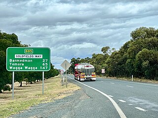
Goldfields Way is a 116-kilometre (72 mi) country road in the northern part of the Riverina region of New South Wales, connecting Wyalong via Temora to Old Junee.

Escort Way is a 114-kilometre (71 mi) country road in New South Wales running from Mitchell Highway in Orange to Lachlan Valley Way in Forbes. The name derives from the notorious hold up of the Lachlan Gold Escort by bushrangers in 1862 which occurred along the route, and subsequent lobbying by the Canowindra Historical Society to recognise this. Escort Rock, a heritage-listed geological formation is located adjacent to the road near Eugowra.

Henry Lawson Way is a 109-kilometre (68 mi) sealed rural road that links Forbes and Young in the central western region of New South Wales, Australia. The road is named in honour of Henry Lawson (1867–1922), an Australian writer and poet, who was born in a town on the Grenfell goldfields, located adjacent to the modern-day rural road.

Remembrance Drive is a rural road that links Camden and Alpine on the fringes of south-western Sydney, New South Wales. The road served as the former alignment of Hume Highway and now forms part of Old Hume Highway.

<span class="mw-page-title-main">Jenolan Caves Road</span> Road in New South Wales, Australia

Jenolan Caves Road is a rural road in New South Wales, Australia, linking Great Western Highway at Hartley to Edith Road at Jenolan.

References

  1. 1 2 3 Google (18 June 2022). "Barrier Highway" (Map). Google Maps . Google. Retrieved 18 June 2022.
  2. 1 2 "Main Roads Act, 1924-1927". Government Gazette of the State of New South Wales. No. 110. National Library of Australia. 17 August 1928. pp. 3814–20. Archived from the original on 3 August 2022. Retrieved 1 August 2022.
  3. "Location SA Map viewer with regional layers". Government of South Australia . Retrieved 16 June 2022.
  4. Barrier Highway (SA) Archived 8 October 2009 at the Wayback Machine , South Australia Central. Retrieved 21 February 2010.
  5. State of New South Wales, An Act to provide for the better construction, maintenance, and financing of main roads; to provide for developmental roads; to constitute a Main Roads Board Archived 11 August 2022 at the Wayback Machine 10 November 1924
  6. State of New South Wales, An Act to amend the Main Roads Act, 1924-1927; to confer certain further powers upon the Main Roads Board; to amend the Local Government Act, 1919, and certain other Acts; to validate certain payments and other matters; and for purposes connected therewith. Archived 12 August 2022 at the Wayback Machine 8 April 1929
  7. The Barrier Highway: Bitumen Sealed from End to End Main Roads December 1972 pages 34-40
  8. State of New South Wales, An Act to make provision with respect to the roads of New South Wales; to repeal the State Roads Act 1986, the Crown and Other Roads Act 1990 and certain other enactments; and for other purposes. Archived 11 August 2022 at the Wayback Machine 10 November 1924
  9. Transport for NSW (August 2022). "Schedule of Classified Roads and Unclassified Regional Roads" (PDF). Government of New South Wales. Archived from the original (PDF) on 25 August 2022. Retrieved 1 August 2022.
  10. "Road number and name changes in NSW" (PDF). Roads & Maritime Services . Government of New South Wales. 2012. Archived from the original (PDF) on 25 March 2016. Retrieved 7 November 2016.
  11. "Location SA Map viewer with LGA layers". Government of South Australia . Retrieved 16 June 2022.
  12. "Location SA Map viewer with suburb layers". Government of South Australia . Retrieved 16 June 2022.