Menindee, New South Wales

Last updated

Menindee
New South Wales
MenindeeAhChungsBakehouseGallery.JPG
Ah Chung's Bakehouse Gallery
Australia New South Wales location map blank.svg
Red pog.svg
Menindee
Coordinates 32°23′33″S142°25′05″E / 32.39250°S 142.41806°E / -32.39250; 142.41806
Population551 (2016 census) [1]
Postcode(s) 2879
Elevation61.0 m (200 ft)
Location
LGA(s) Central Darling Shire
State electorate(s) Barwon
Federal division(s) Parkes [2]
Mean max tempMean min tempAnnual rainfall
25.9 °C
79 °F
11.3 °C
52 °F
245.8 mm
9.7 in

Menindee (frequently but erroneously spelled "Menindie" [3] ) is a small town in the far west of New South Wales, Australia, in Central Darling Shire, on the banks of the Darling River, with a sign-posted population of 980 and a 2016 census population of 551. [1] Menindee was the first town to be established on the Darling River. [4] There are two distinct theories for the derivation of the township’s name: (a) from the Barkindji word "minandichi" for the shallow ephemeral lake north-west of the present-day township; [5] (b) from the Barkindji word 'milhthaka', meaning "yolk of an egg". [6] [3]

Contents

History

Aboriginal occupation

The Menindee district lies within the traditional lands of the Barkindji people, who occupied the area for thousands of years before the arrival of Europeans, with evidence of previous Aboriginal activities going back 35,000 years. [7] Aboriginal people became increasingly concentrated along the Darling River as the nearby Willandra Lakes system began to dry out after the last ice age 20,000 years ago. The area around present-day Menindee was a particularly productive region for Aboriginal occupation with its overflow lakes and channels in combination with the riverine environment. [8]

European exploration

The first Europeans into the region was an exploring party led by Major Thomas Mitchell in 1835. The expedition had travelled down the Bogan and Darling rivers, intending to follow the course of the Darling to its junction with the Murray. Mitchell and his men encountered bouts of hostility from aboriginal groups as they progressed. In the area of the Menindee Lakes the expedition was subject to increasing confrontation from the native inhabitants and Mitchell decided it would be too dangerous to proceed and decided to turn back. [9] Mitchell named the ephemeral lakes in the area 'Laidley's Chain of Ponds' after James Laidley, the Deputy Commissary-General of New South Wales. The Barkindji people called the lakes 'wontanella' meaning "many waters". [7]

An expedition led by Charles Sturt arrived at Laidley’s Ponds in October 1844, the initial stage of a series of explorations in Central Australia searching for the north-south watershed of the continent and an inland sea. The party established a base camp at Lake Cawndilla (south-west of present-day Menindee) and over two months made several scouting expeditions into and beyond the Barrier Range. In December 1844 Sturt’s party moved further north to the Grey Range, after which they undertook a number of exploratory trips into the dry interior, before returning to Adelaide in January 1846. [5] [10]

European settlement

'Junction of the Paramaru Creek with the River Darling'
Hermann Beckler (1861) Junction of the Pamamaru River.png
'Junction of the Paramaru Creek with the River Darling'
Hermann Beckler (1861)

The Darling Pastoral District between the Murrumbidgee and Darling rivers was officially proclaimed on 4 December 1847. [11] In 1849 Alexander McCallum took up the 'Menindee' pastoral lease. In September 1850 it was reported that "the commandant of the Native Police… and his gallant band" were "at Laidley Ponds" to investigate "aggressions… committed on shepherds". The account stated that "the natives had been very troublesome, and some parties had been obliged to abandon their stations." [12] In 1851 the government surveyor Francis McCabe surveyed and mapped the lower Darling River. His plan of survey named the locality as "Minnindia". [3] In about 1852 Thomas Pain, with his wife Bridget and children, settled at the site of Menindee and built a shanty hotel to provide services to travellers along the Darling River. [4] Another source states the public house was built in about 1855, possibly by "a man named Williams". [13] In any case Thomas Pain was certainly in possession of the building by 1860.

In late January 1859 Captain Francis Cadell in charge of the Albury steamer entered the Darling River at its junction with the Murray and after four days travel he reached the site of Menindee before continuing on for a further four days until he reached the 'Mount Murchison' pastoral run. [14] Cadell’s pioneering voyage on the Darling "demonstrated that the river could be navigated for the purpose of carrying on trade". [13]

In 1860 Thomas Pain was contracted to take mail on horseback once a fortnight along the Darling between Wentworth to Mount Murchison. [15] Francis Cadell established a depot store at Menindee (which he sold in about 1862). [16]

The Burke and Wills expedition camped at Menindee on their journey to cross Australia from Melbourne to the Gulf of Carpentaria. They arrived here on 14 October 1860, crossed the Darling River at Kinchega Station and made Camp XXXIV (their thirty-fourth camp since leaving Melbourne). There was dissent within the party and the deputy-leader George Landells resigned. Robert O'Hara Burke split the party, heading north to Cooper Creek with half the men, stores and animals. The remaining men, stores and animals made a depot camp at Pamamaroo Creek (a sign and cairn mark the site of the camp). This camp was used for the remainder of 1860 and for most of 1861. While in Menindee, Burke stayed at Thomas Pain's hotel. Pain was later reimbursed by the Victorian Exploration Committee for outstanding accounts. [4]

In October 1861 Menindee was described as a settlement consisting of the following buildings: "a public-house, a store, and a hut in the occupation of the police". The population of permanent residents numbered "about fifteen souls, including women and children". [17]

A government township

The Menindee Post Office, erected in 1881. Menindee Post Office-1 (5150300850).jpg
The Menindee Post Office, erected in 1881.

The location of Menindee was surveyed in preparation for land sales in 1861 and the name "Perry" ("with but little regard for euphony") chosen by the colonial government. [17] In June 1862 it was notified that "the approved Plan" for "a Town to be called Perry" had been deposited for public inspection in Sydney and with "the Land Agent at Wentworth". [18] The name "Perry" was unpopular with the locals and the subject of ridicule in the colonial press. One report in July 1862 speculated that the name was a "cheap honor, we suppose, to some political snob" and suggested that "winkle" might have been added to the name "and then we should have known what creature was intended to be honored". [19] The first land sales at Perry (Menindee) were held in July 1862. [20] In November 1863 the previous notification for the town to be called "Perry" was rescinded. The notice in the Government Gazette explained that "it has been considered expedient to alter the name of the Town in question to the native name of the locality, viz., Menindee, by which it is not only better known by the Colonists, but has become celebrated in the annals of Australian Exploration". [21]

In 1866 Thomas Pain sold his inn "to a man named Robertson or Robinson" and "after a few months it again changed hands". The new owner was Christopher Quinn who was granted a publican’s license in July 1866 (probably the first license obtained for the establishment). Quinn named his public house the Menindie Hotel. [13] [22]

An application was submitted in 1868 for a government school at Menindee. [23] Classes began in a temporary structure in 1869. [24] In June 1873 it was reported that the Council of Education in Sydney was experiencing "great difficulty in providing a teacher for the public school at Menindie… on account of the distance of that place from Sydney". [25]

It was recorded in September 1875 that "Menindie maintains a public Hospital, a Catholic Church, besides hotels and stores". [26]

In November 1878 Menindee was described as "yet only a small place", consisting of "four public-houses, two good stores, a Post and Telegraph Office, Court-house, a Police-station, with its necessary adjuncts, and, as near as I could judge, about twenty cottages scattered about". [27]

At the time of the 1881 Census Menindee had a population of 261 persons (156 males and 105 females). [28] A new post and telegraph office was completed at Menindee in 1881. Soon after it was built it was described by a correspondent as "by far the most handsome building in the town". A visitor to Menindee in August 1881 described the lay-out of the town as "higgledy-piggledy", adding: "Perched on a collection of little sandhills, which effectually raise it above all floods, it is composed of buildings, most of them brick, which, judging from their appearance, might have been dropped down by chance, like a collection of children's toy bricks". [29]

At the time of the 1891 Census Menindee had a population of 194 persons (113 males and 81 females). [28]

A January 1924 account of Menindee describes it as "probably the most casual of all villages in the State". The "dozen or so houses that constitute Menindie" seemed to be set out without a town-plan; "of streets or roads, there are none, the only few yards of made surface being the approach to the punt". [30]

A direct railway connection between Sydney and Broken Hill was accomplished with the completion in October 1927 of a railway bridge over the Darling near Menindee. The iron bridge was of the bascule type, with a centre span hinging at one end to permit river steamers to pass. The bridge had provision for a roadway as well as a railway on a single deck. [31] [32]

Heritage listings

Menindee has a number of heritage-listed sites, including:

Population

According to the 2016 census of Population, there were 551 people in Menindee.

Schools

Menindee Central School serving K-12.

Geography

The village of Menindee sits on a sandhill above the floodplain on the north bank of the Darling River. The sand dunes and sand plains of the area are characterised by light-textured red sand and loams which are susceptible to wind erosion. The floodplain is characterised by a grey cracking clay (black soil) supporting open woodlands dominated by black box trees. [8]

The Kinchega National Park is situated on the western edge of town.

Natural environment

Menindee nightshade

The threatened Menindee nightshade ( Solanum karsense) is named after the Menindee region, one of the locations where it is known to occur. It is a grey-green downy forb with spines scattered along the stems, bearing purple flowers (typically solanum-type) in spring. The Menindee nightshade is restricted to the far south-western plains of NSW, mainly in the area between the Darling and Lachlan rivers, along the Darling between Menindee and Wilcannia, and across to Broken Hill. It has been recorded from Kinchega National Park near Menindee. [34]

Water supply

A weir on the Darling River near Menindee diverts water from the river into a series of shallow, otherwise dry, overflow lakes. The Menindee Lakes, also known as the Menindee Water Storage Scheme, regulate the river flow for irrigation downstream into South Australia.

Menindee residents had complained about the town's "putrid" water quality and claimed that cotton growers were removing water from the river during the recent drought. [35] Generally the health of river systems is reliant on summer rains. Some locals were carting water from other sources. The WaterNSW advised property owners not to water their stock from the Darling.

The river is subject to blooms of blue green algae in summer. Richard Kingsford, Director of the Centre for Ecosystem Science at the University of NSW said the Menindee Lakes had been drained more often than in the past. In July 2018, 23 gigalitres of environmental water was delivered to the Darling River; this reconnected isolated parts of the river and flushed out algae.

In early 2019, up to one million native fish were found dead along a 40-kilometre stretch of the river in Menindee, including the large and critically endangered Murray cod. The apparent trigger for these deaths was a sudden drop in temperature, causing much of the algae bloom to decompose. The levels of dissolved oxygen in the river then fell too low for the fish to survive.

Widespread rainfall over north-west NSW and southern Queensland during January/February 2020 started to flow into Menindee Lakes (Lake Wetherell) on 10 March. [36] It was estimated that over 550 gigalitres would reach Menindee Lakes as a result of this flow event. Increased numbers of waterbirds have been observed in the area. The area flooded again in early 2023. [37]

Climate

Menindee has a hot desert climate (BWh) under the Köppen climate classification, featuring hot, dry summers and short, cool winters. The annual average rainfall is 284.6 millimetres (11.2 in) which would make it a semi-arid climate except that its high evapotranspiration, or its barrenness, makes it a desert climate. Rainfall varies significantly from year to year, with the town often going without rainfall for months on end, but occasional severe rainstorms can cause falls of over 100 mm in a day, the last time this happened being January 2011.

Menindee is tied with Bourke in recording the highest temperature in New South Wales, with a temperature of 49.7 °C (121.5 °F) recorded on 10 January 1939.

Climate data for Menindee (1876–2012)
MonthJanFebMarAprMayJunJulAugSepOctNovDecYear
Record high °C (°F)49.7
(121.5)
47.2
(117.0)
43.4
(110.1)
41.7
(107.1)
33.3
(91.9)
28.9
(84.0)
28.9
(84.0)
32.3
(90.1)
39.5
(103.1)
42.8
(109.0)
46.4
(115.5)
48.9
(120.0)
49.7
(121.5)
Average high °C (°F)34.4
(93.9)
33.8
(92.8)
30.7
(87.3)
25.6
(78.1)
20.7
(69.3)
17.3
(63.1)
17.0
(62.6)
19.3
(66.7)
22.9
(73.2)
26.5
(79.7)
30.0
(86.0)
32.8
(91.0)
25.9
(78.6)
Average low °C (°F)18.5
(65.3)
18.2
(64.8)
15.2
(59.4)
10.9
(51.6)
7.5
(45.5)
5.0
(41.0)
4.1
(39.4)
5.3
(41.5)
8.0
(46.4)
11.3
(52.3)
14.6
(58.3)
16.8
(62.2)
11.3
(52.3)
Record low °C (°F)7.0
(44.6)
6.4
(43.5)
3.9
(39.0)
2.0
(35.6)
−1.6
(29.1)
−2.8
(27.0)
−3.5
(25.7)
−2.0
(28.4)
0.2
(32.4)
1.0
(33.8)
1.7
(35.1)
6.0
(42.8)
−3.5
(25.7)
Average rainfall mm (inches)24.0
(0.94)
21.7
(0.85)
18.8
(0.74)
16.8
(0.66)
22.7
(0.89)
21.4
(0.84)
18.3
(0.72)
17.9
(0.70)
18.4
(0.72)
22.8
(0.90)
21.2
(0.83)
21.8
(0.86)
245.8
(9.65)
Average precipitation days2.52.62.52.84.14.85.04.93.93.93.32.843.1
Source: Bureau of Meteorology [38]

Transport

The transcontinental railway line crosses the Darling River at Menindee. The railway line is about 900 kilometres west of Sydney and about 110 km south-east of Broken Hill. Menindee is served by the NSW TrainLink Outback Xplorer service between Sydney and Broken Hill with one train in each direction per week. [39] Trains head west (to Broken Hill) on Mondays and east on Tuesdays.

A community access bus service runs to Broken Hill and return Monday to Friday (except public holidays), run by CDC Broken Hill (formerly Murton's City Bus Pty Ltd). [40]

No major highway runs through Menindee but the Barrier Highway between Adelaide and Nyngan runs nearby to the north through Broken Hill.

See also

Related Research Articles

<span class="mw-page-title-main">Kinchega National Park</span> Protected area in New South Wales, Australia

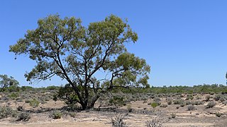
The Kinchega National Park is a protected national park that is located in the Far West region of New South Wales, in eastern Australia.The 44,259-hectare (109,370-acre) national park is located approximately 840 kilometres (520 mi) west of Sydney and 111 kilometres (69 mi) south-east of Broken Hill. The park adjoins the town of Menindee. The eastern edge of the Kinchega National Park is formed by the Darling River.

<span class="mw-page-title-main">Broken Hill</span> Town in New South Wales, Australia

Broken Hill is a city in the far west region of outback New South Wales, Australia. An inland mining city, is near the border with South Australia on the crossing of the Barrier Highway (A32) and the Silver City Highway (B79), in the Barrier Range. It is 315m above sea level, with a hot desert climate, and an average rainfall of 235mm. The closest major city is Mildura, 300km to the south and the nearest State Capital City is Adelaide, the capital of South Australia, which is more than 500km to the southwest and linked via route A32.

<span class="mw-page-title-main">Hamilton Hume</span> Australian explorer (1797–1873)

Hamilton Hume was an early explorer of the present-day Australian states of New South Wales and Victoria. In 1824, along with William Hovell, Hume participated in an expedition that first took an overland route from Sydney to Port Phillip. Along with Sturt in 1828, he was part of an expedition of the first Europeans to find the Darling River.

<span class="mw-page-title-main">Burke and Wills expedition</span> Australian exploration expedition (1860–61)

The Burke and Wills expedition was organised by the Royal Society of Victoria in Australia in 1860–61. It initially consisted of 19 men led by Robert O'Hara Burke, with William John Wills being a deputy commander. Its objective was the crossing of Australia from Melbourne in the south to the Gulf of Carpentaria in the north, a distance of around 3,250 kilometres. At that time most of the inland of Australia had not been explored by non-Indigenous people and was largely unknown to the European settlers.

<span class="mw-page-title-main">Charles Sturt</span> Australian explorer (1795-1869)

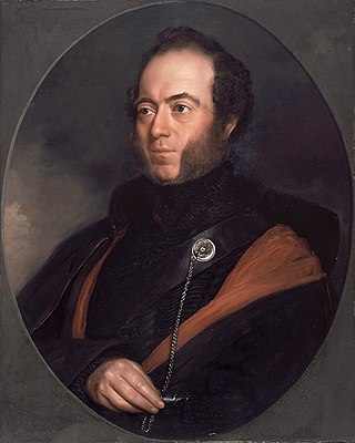
Charles Napier Sturt was a British officer and explorer of Australia, and part of the European exploration of Australia. He led several expeditions into the interior of the continent, starting from Sydney and later from Adelaide. His expeditions traced several of the westward-flowing rivers, establishing that they all merged into the Murray River, which flows into the Southern Ocean. He was searching to prove his own passionately held belief that an "inland sea" was located at the centre of the continent. He reached the rank of Captain, served in several appointed posts, and on the Legislative Council.

<span class="mw-page-title-main">Darling River</span> Major river in Australia

The Darling River is the third-longest river in Australia, measuring 1,472 kilometres (915 mi) from its source in northern New South Wales to its confluence with the Murray River at Wentworth. Including its longest contiguous tributaries it is 2,844 km (1,767 mi) long, making it the longest river system in Australia. The Darling River is the outback's most famous waterway.

<span class="mw-page-title-main">Thomas Mitchell (explorer)</span> Scottish surveyor and explorer of south-eastern Australia (1792-1855)

Sir Thomas Livingstone Mitchell, often called Major Mitchell, was a surveyor and explorer of Southeastern Australia. He was born in Scotland and served in the British Army during the Peninsular War. In 1827 he took up an appointment as Assistant Surveyor General of New South Wales. The following year he became Surveyor General and remained in this position until his death. Mitchell was knighted in 1839 for his contribution to the surveying of Australia.

<span class="mw-page-title-main">Murray–Darling basin</span> Largest Australian river catchment

The Murray–Darling Basin is a large geographical area in the interior of southeastern Australia, encompassing the drainage basin of the tributaries of the Murray River, Australia's longest river, and the Darling River, a right tributary of the Murray and Australia's third-longest river. The Basin, which includes six of Australia's seven longest rivers and covers around one-seventh of the Australian landmass, is one of the country's most significant agricultural areas providing one-third of Australia's food supply. Located west of the Great Dividing Range, it drains southwest into the Great Australian Bight and spans most of the states of New South Wales and Victoria, the Australian Capital Territory, and parts of the states of Queensland and South Australia.

<span class="mw-page-title-main">Wilcannia</span> Town in New South Wales, Australia

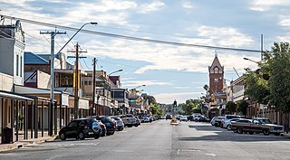
Wilcannia is a small town located within the Central Darling Shire in north western New South Wales, Australia. Located on the Darling River, the town was the third largest inland port in the country during the river boat era of the mid-19th century. At the 2016 census, Wilcannia had a population of 745.

<span class="mw-page-title-main">Silverton, New South Wales</span> Town in New South Wales, Australia

Silverton is a small village at the far west of New South Wales, Australia, 26 kilometres (16 mi) north-west of Broken Hill. At the 2016 census, Silverton had a population of 50.

<span class="mw-page-title-main">Tibooburra</span> Town in New South Wales, Australia

Tibooburra is a town in the far northwest of New South Wales, Australia, located 1,187 kilometres (738 mi) from the state capital, Sydney. It is most frequently visited by tourists on their way to Sturt National Park or on the way to or from Innamincka in South Australia and Birdsville in Queensland. At the 2016 census, Tibooburra had a population of 134. Although facilities in Tibooburra are quite limited, fuel, meals, and a range of accommodation options are available. All significant support services are based in Broken Hill.

<span class="mw-page-title-main">Pooncarie</span> Town in New South Wales, Australia

Pooncarie is a village in south-western New South Wales, Australia in Wentworth Shire. It is on the eastern side of the Darling River between Wentworth and Menindee. The surrounding region of Pooncarie is semi-arid with an outback landscape rich in eucalypt woodlands.

<span class="mw-page-title-main">John McKinlay</span>

John McKinlay was a Scottish-born Australian explorer and cattle grazier, and leader of the South Australian Burke Relief Expedition - one of the search parties for the Burke and Wills expedition. McKinlay was also a member of Charles Sturt's Central Exploring Expedition from 1844-1845. The town of McKinlay in north western Queensland is named after him.

Cobar was an electoral district of the Legislative Assembly in the Australian state of New South Wales which was named after the town of Cobar. It was first created in 1894 and abolished in 1920. Cobar was recreated in 1930 and abolished in 1968.

<span class="mw-page-title-main">Broken Hill railway station</span> Railway station in New South Wales, Australia

Broken Hill railway station is a heritage-listed railway station located on the Broken Hill line in Broken Hill, New South Wales, Australia. It was added to the New South Wales State Heritage Register on 2 April 1999.

<span class="mw-page-title-main">Menindee Lakes</span> Shallow freshwater lakes in New South Wales

The Menindee Lakes is a system of 9 large, but relatively shallow lakes, located in south-west New South Wales on the Darling (Barka) River, about 200 km upstream of the Darling River's junction with the River Murray. The Darling River is fed by nine major tributary river systems flowing from south-east Queensland and north and central NSW. The town of Menindee is close to the lakes and the nearest city is Broken Hill.

<span class="mw-page-title-main">Menindee railway station</span> Railway station in New South Wales, Australia

Menindee railway station is located on the Broken Hill line in New South Wales, Australia. It serves the town of Menindee.

<span class="mw-page-title-main">Parish of Wallandra</span> Civil parish in New South Wales, Australia

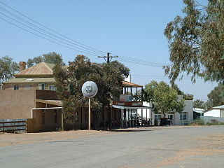
Wallandra Parish in Cobar Shire is a civil parish of Rankin County, a Cadastral division of New South Wales. The Parish is on the Darling River upstream of Wilcannia, New South Wales and is located at 30.5511°N 144.3351°E. The only town of the parish is Tilpa, New South Wales.

<span class="mw-page-title-main">Kinchega Woolshed</span> Heritage-listed former shearing shed in NSW, Australia

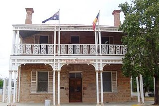
Kinchega Woolshed is a heritage-listed former shearing shed located 15km south-west of Menindee township, Central Darling Shire, New South Wales, Australia. It was built from in 1875. The property is owned by the New South Wales Office of Environment and Heritage. It was added to the New South Wales State Heritage Register on 2 April 1999.

<span class="mw-page-title-main">Bonny Parish (County of Killara), New South Wales</span>

Bonny Parish, New South Wales is a civil parish of Killara County, in Central Darling Shire.

References

  1. 1 2 3 Australian Bureau of Statistics (27 June 2017). "Menindee (State Suburb)". 2016 Census QuickStats. Retrieved 25 January 2018. OOjs UI icon edit-ltr-progressive.svg
  2. "Profile of the electoral division of Parkes (NSW)". Australian Electoral Commission. 25 February 2016. Archived from the original on 1 July 2016. Retrieved 12 July 2016.
  3. 1 2 3 "Menindee, not Menindie". The Barrier Miner . Broken Hill, NSW. 12 December 1934. p. 4. Archived from the original on 18 March 2023. Retrieved 15 June 2013 via National Library of Australia.
  4. 1 2 3 Maiden, Sandra (1989). Menindee, First Town on the River Darling: A Brief History. Sunnyland Press. ISBN   0731669312.
  5. 1 2 Sturt, Charles (1848–49). Narrative of an Expedition into Central Australia. London: T. and W. Boone. Archived from the original on 13 March 2022. Retrieved 26 February 2021.
  6. "Menindee". Geographical Names Board. NSW Government. Archived from the original on 26 March 2022. Retrieved 27 February 2021. – citing The Cambridge Dictionary of Australian Places, compiled and written by Richard and Barbara Appleton, Cambridge University Press, 1992 (ISBN 0521395062).
  7. 1 2 "Menindee, NSW". Aussie Towns. Archived from the original on 26 February 2021. Retrieved 26 February 2021.
  8. 1 2 "Kinchega National Park". Geological sites of NSW. Cartoscope Pty Ltd. Archived from the original on 22 March 2021. Retrieved 2 March 2021.
  9. Mitchell, Thomas (1839). Journal of an Expedition sent to explore the course of the River Darling in 1835 in Three Expeditions into the interior of Eastern Australia. London: T.& W. Boone.
  10. H. J. Gibbney. Sturt, Charles (1795-1869). Archived from the original on 8 March 2021. Retrieved 27 February 2021.{{cite book}}: |website= ignored (help)
  11. "Willandra Lakes". New South Wales State Heritage Register . Department of Planning & Environment. H01010. Retrieved 2 March 2021. CC BY icon.svg Text is licensed by State of New South Wales (Department of Planning and Environment) under CC-BY 4.0 licence .
  12. 'Darling Downs', Sydney Morning Herald, 19 September 1850, page 3.
  13. 1 2 3 'The Early Days of Menindie', Barrier Miner (Broken Hill), 15 April 1933, page 4.
  14. 'Navigation of the Darling', Sydney Morning Herald, 12 March 1859, page 7.
  15. Withers, Maxine (1989). Bushmen of the Great Anabranch. M. Withers. ISBN   0731681231.
  16. South Australian Register (Adelaide), 17 December 1861, page 1.
  17. 1 2 'Mr Haverfield’s Notes on the North' (Robert Ross Haverfield), The Star (Ballarat), 25 October 1861, page 1.
  18. New South Wales Government Gazette, 17 June 1862 (Issue No. 104), page 1092.
  19. 'Names of Places', The Courier (Brisbane), 18 July 1862, page 2.
  20. New South Wales Government Gazette, 12 June 1862 (Issue No. 101 Supplement), page 1068.
  21. New South Wales Government Gazette, 24 November 1863 (Issue No. 223), page 2558.
  22. New South Wales Government Gazette, 7 August 1866 (Issue No. 152 Supplement), page 1869.
  23. New South Wales Government Gazette, 9 April 1868 (Issue No. 88), page 1048.
  24. South Australian Register (Adelaide), 1 November 1869, page 3.
  25. South Australian Register (Adelaide), 24 June 1873, page 3.
  26. Southern Argus (Port Elliot, S.A.), 2 September 1875, page 4.
  27. 'To Riverina: No. IV: Wentworth to Menindie', South Australian Advertiser (Adelaide), 18 November 1878, page 5.
  28. 1 2 Australian Bureau of Statistics; Australian Data Archive; Smith, Len; Rowse, Tim; Hungerford, Stuart (2021). "Historical and Colonial Census Data Archive (HCCDA)". Australian National University. doi:10.26193/MP6WRS. Archived from the original on 6 March 2021. Retrieved 1 March 2021.{{cite journal}}: Cite journal requires |journal= (help)
  29. 'Pooncaria to Menindie and District, River Darling' (by 'The Raven'), Australian Town and Country Journal, 6 August 1881, page 27.
  30. 'Menindie', Tweed Daily (Murwillumbah), 5 January 1924, page 8.
  31. 'New Railway route to Broken Hill', Sydney Mail, 2 November 2927, page 10.
  32. 'The Broken Hill Railway Link', Albury Banner and Wodonga Express, 14 October 1927, page 31.
  33. "Kinchega Woolshed". New South Wales State Heritage Register . Department of Planning & Environment. H00995. Retrieved 18 May 2018. CC BY icon.svg Text is licensed by State of New South Wales (Department of Planning and Environment) under CC-BY 4.0 licence .
  34. "Menindee Nightshade - profile". Threatened species. Office of Environment & Heritage, NSW Government. Archived from the original on 6 March 2021. Retrieved 5 March 2021.
  35. video shows dead 'century-old fish' Archived 22 January 2019 at the Wayback Machine SMH 9 January 2019
  36. "Water in New South Wales, drought update". NSW Department of Planning, Industry and Environment. 12 June 2020. Archived from the original on 15 July 2020. Retrieved 13 July 2020.
  37. "Major flooding in Menindee expected to persist for weeks". www.abc.net.au. 4 January 2023. Archived from the original on 4 January 2023. Retrieved 4 January 2023.
  38. "Menindee Post Office". Climate statistics for Australian locations. Bureau of Meteorology. March 2013. Retrieved 18 March 2013.
  39. "Transportnsw.info". transportnsw.info. Archived from the original on 12 August 2020. Retrieved 5 June 2020.
  40. "Central Darling Shire". centraldarling.nsw.gov.au. Archived from the original on 5 June 2020. Retrieved 5 June 2020.

Wikivoyage-Logo-v3-icon.svg Menindee travel guide from Wikivoyage