Lake Gairdner National Park is a protected area associated with Lake Gairdner in South Australia (Australia), 436 km northwest of Adelaide. It is located just south of the Trans-Australian Railway, Stuart Highway, and the Woomera Prohibited area.

The Shire of Indigo, a local government area (LGA) in the Hume region of Victoria, Australia, lies in the north-east part of the state. It covers an area of 2,040 square kilometres (790 sq mi) and in August 2021 had a population of 17,368.

The Wheatbelt is one of nine regions of Western Australia defined as administrative areas for the state's regional development, and a vernacular term for the area converted to agriculture during colonisation. It partially surrounds the Perth metropolitan area, extending north from Perth to the Mid West region, and east to the Goldfields–Esperance region. It is bordered to the south by the South West and Great Southern regions, and to the west by the Indian Ocean, the Perth metropolitan area, and the Peel region. Altogether, it has an area of 154,862 square kilometres (59,793 sq mi).

Halls Creek is a town situated in the east Kimberley region of Western Australia. It is located between the towns of Fitzroy Crossing and Turkey Creek (Warmun) on the Great Northern Highway. It is the only sizable town for 600 km on the Highway.

The Shire of Plantagenet is a local government area in the Great Southern region of Western Australia, managed from the town of Mount Barker, 360 kilometres (224 mi) south of Perth and 50 kilometres (31 mi) north of Albany. The shire covers an area of 4,792 square kilometres (1,850 sq mi) and includes the communities of Narrikup, Rocky Gully, Kendenup and Porongurup.
The Shire of Noosa is a local government area about 130 kilometres (81 mi) north of Brisbane in the Sunshine Coast district of South East Queensland, Australia. The shire covers an area of 870 square kilometres (335.9 sq mi). It existed as a local government entity from 1910 until 2008, when it was amalgamated with the Shire of Maroochy and City of Caloundra to form the Sunshine Coast Region. The shire was re-established on 1 January 2014. In the 2021 census, the shire had a population of 56,298 people.

Yarrawonga is a town in the Shire of Moira local government area in the Australian state of Victoria. The town is situated on the south bank of the Murray River, the border between Victoria and New South Wales, and is located approximately 265 kilometres (165 mi) north-east of the state capital, Melbourne. Yarrawonga's twin town of Mulwala is on the other side of the Murray River. At the 2016 census, Yarrawonga had a population of 7,930.

Murrumbidgee Shire was a local government area in the Riverina region of south western New South Wales, Australia. The Shire was located adjacent to the Murrumbidgee River and the Newell Highway.

Perenjori is a townsite in the northern agricultural region, 348 kilometres (216 mi) north of Perth and 39 kilometres (24 mi) south-east of Morawa. It is located on the Wongan Hills to Mullewa railway line which was opened in 1915. Perenjori was approved as the name of a siding in April 1913, and later that year the government decided to establish a townsite there. Perenjori townsite was gazetted in 1916.

UTC+08:45 is an identifier for a time offset from UTC of +08:45.

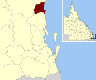
The Shire of Douglas is a local government area in Far North Queensland. It is located on the coast north of the city of Cairns. The shire, administered from the town of Mossman, covers an area of 2,428 square kilometres (937.5 sq mi), and existed as a local government entity from 1880 until 2008, when it was amalgamated with the City of Cairns to become the Cairns Region. Following a poll in 2013, the Shire of Douglas was re-established on 1 January 2014.
The Shire of Morawa is a local government area in the Mid West region of Western Australia, about 170 kilometres (106 mi) east-southeast of the city of Geraldton and about 390 kilometres (242 mi) north of the state capital, Perth. The Shire covers an area of 3,516 square kilometres (1,358 sq mi), and its seat of government is the town of Morawa.

The Shire of Charlton was a local government area about 240 kilometres (149 mi) north-northwest of Melbourne, the state capital of Victoria, Australia. The shire covered an area of 1,175 square kilometres (453.7 sq mi), and existed from 1895 until 1995.
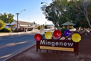
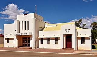
Mingenew is a town in Western Australia, located 383 kilometres (238 mi) north of the state capital, Perth. It is the seat of government for the Shire of Mingenew.

The Gulf Country or North West Queensland is the region of woodland and savanna grassland surrounding the Gulf of Carpentaria in north western Queensland and eastern Northern Territory on the north coast of Australia. The region is also called the Gulf Savannah. The Gulf Country is crossed by the Savannah Way highway.
Katamatite East is a locality in Victoria, Australia in the local government area of the Shire of Moira. Cobram East borders the north of the locality, Katamatite borders the west and south of the locality, and Boosey borders the east of the locality.
Belyando was an electoral district of the Legislative Assembly in the Australian state of Queensland in 2 incarnations from 1950 to 1977.
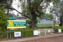
Mount Murchison is a rural locality in the Shire of Banana, Queensland, Australia.
The Shire of Boulder was a local government area in Western Australia. It was established as the East Coolgardie Road District on 15 February 1895. It was renamed the Kalgoorlie Road District on 24 September 1897. The board's offices were located at 39 Porter Street, Kalgoorlie; the building survives today and has been classified by the National Trust of Australia.