Wantirna is a suburb in Melbourne, Victoria, Australia, 27 km east of Melbourne's Central Business District, located within the City of Knox local government area. Wantirna recorded a population of 14,237 at the 2021 census.
Box Hill North is a suburb of Melbourne, Victoria, Australia, 14 km east from Melbourne's Central Business District, located within the City of Whitehorse local government area. Box Hill North recorded a population of 12,337 at the 2021 census.

Box Hill South is a suburb of Melbourne, Victoria, Australia, 14 km east of Melbourne's Central Business District, located within the City of Whitehorse local government area. Box Hill South recorded a population of 8,491 at the 2021 census.

Dandenong is a southeastern suburb of Melbourne, Victoria, Australia, about 35 km (22 mi) from the Melbourne CBD. It is the council seat of the City of Greater Dandenong local government area, with a recorded population of 30,127 at the 2021 census. Situated mainly on the northwest bank of the lower Dandenong Creek, it is 21.6 km (13.4 mi) from the eponymous Dandenong Ranges to its northeast and completely unrelated in both location and nature of the settlement.

Coburg is a suburb in Melbourne, Victoria, Australia, 8 km (5.0 mi) north of Melbourne's Central Business District, located within the Cities of Darebin and Merri-bek local government areas. Coburg recorded a population of 26,574 at the 2021 census.

Hoppers Crossing is a suburb in Melbourne, Victoria, Australia, 24 km (15 mi) south-west of Melbourne's Central Business District, located within the City of Wyndham local government area. Hoppers Crossing recorded a population of 37,216 at the 2021 census.

Kooyong is a suburb in Melbourne, Victoria, Australia, 7 km south-east of Melbourne's Central Business District, located within the City of Stonnington local government area. Kooyong recorded a population of 842 at the 2021 census.

South Yarra is an inner-city suburb in Melbourne, Victoria, Australia, 4 km south-east of Melbourne's Central Business District, located within the Cities of Melbourne and Stonnington local government areas. South Yarra recorded a population of 25,028 at the 2021 census.

Prahran, is an inner suburb in Melbourne, Victoria, Australia, 5 km south-east of Melbourne's Central Business District, located within the City of Stonnington local government area. Prahran recorded a population of 12,203 at the 2021 census.

Brunswick East is an inner-city suburb in Melbourne, Victoria, Australia, 5 km (3.1 mi) north of Melbourne's Central Business District, located within the City of Merri-bek local government area. Brunswick East recorded a population of 13,279 at the 2021 census.

Oak Park is a suburb in Melbourne, Victoria, Australia, 11 km (6.8 mi) north of Melbourne's Central Business District, located within the City of Merri-bek local government area. Oak Park recorded a population of 6,714 at the 2021 census.

Pitt Town is a historic town and suburb of Sydney, in the state of New South Wales, Australia. Pitt Town is 59 kilometres north-west of the Sydney central business district in the local government area of the City of Hawkesbury. It is bounded in the north by the Hawkesbury River.
Sri Lankan Australians are people of Sri Lankan heritage living in Australia; this includes Sri Lankans by birth and by ancestry. Sri Lankan Australians constitute one of the largest groups of Overseas Sri Lankan communities and are the largest diasporic Sri Lankan community in Oceania. Sri Lankan Australians consist of people with Sinhalese, Tamil, Moor, Burgher, Malay and Chinese origins among others.

Ebenezer is a historic town in New South Wales, Australia, in the local government area of the City of Hawkesbury. Ebenezer is located 69 kilometres north-west of Sydney and about 5 kilometres from the larger centre of Wilberforce. It sits on the banks of the Hawkesbury River and like typical early 19th century villages in NSW, it straggles along the roads rather than compactly around a village centre.

Castambul is a small locality near Adelaide, South Australia. It is located in the Adelaide Hills Council local government area.

Guildford is a small settlement situated on the Loddon River, 124 kilometres (77 mi) north-west of Melbourne, in Victoria, Australia. It is located on the Midland Highway between Daylesford and Castlemaine. The population recorded at the 2016 census was 333.
Woolsthorpe is a small town in the Shire of Moyne, Victoria, Australia. It is situated at the intersection of the Woolsthorpe-Heywood, Koroit-Woolsthorpe, and Warrnambool-Caramut Roads, on the banks of Spring Creek. There is a local pub, the National Hotel. At the 2016 census, Woolsthorpe had a population of 422, down from 694 in 2006. The nearest large town is Warrnambool 26.5 kilometres further south.
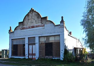
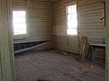
Majorca is a locality in central Victoria, Australia. The locality is in the Shire of Central Goldfields, 11 kilometres (6.8 mi) south of Maryborough and 171 kilometres (106 mi) north west of the state capital, Melbourne. At the 2006 census, Majorca and the surrounding rural area had a population of 387. By the time of the 2016 census the population had declined to 211.
Douglas-Daly is a locality in the Northern Territory of Australia located about 154 kilometres (96 mi) south of the territory capital of Darwin.
Croobyar is a rural suburb of the Milton-Ulladulla district within the City of Shoalhaven on the New South Wales South Coast in Australia. It is located immediately west of Milton and in 2021 the population was 174. The main industry in Croobyar is dairy farming.