Canterbury is an eastern suburb of Melbourne, Victoria, Australia, 10 km from Melbourne's Central Business District, located within the City of Boroondara local government area. Canterbury recorded a population of 7,800 at the 2021 census.

South Yarra is an inner-city suburb in Melbourne, Victoria, Australia, 4 km south-east of Melbourne's Central Business District, located within the Cities of Melbourne and Stonnington local government areas. South Yarra recorded a population of 25,028 at the 2021 census.

Avoca is a town in the Central Highlands of Victoria, Australia, 71 kilometres (44 mi) north west of Ballarat. It is one of two main towns in the Pyrenees Shire, the other being Beaufort to the south.

Homebush is a locality 10 kilometres (6 mi) from Avoca in central Victoria, Australia. It is located within the Pyrenees Shire.

St Arnaud is a town in the Wimmera region of Victoria, Australia, 244 kilometres north west of the capital Melbourne. It is in the Shire of Northern Grampians local government area. At the 2021 census, St Arnaud had a population of 2,318.

Charlton is a town in Victoria, Australia. It is a small agricultural community straddling the Avoca River, located at the junction of the Calder Highway (A79) and Borung Highway (C239) and positioned in the last of the foothills of the Great Dividing Range. Halfway between Melbourne and Mildura, Charlton is a popular tourist stop.
Corindhap is a town in the Australian state of Victoria located on the Ballarat-Colac Road, 38.9 km from Ballarat and 62.9 km from Colac. Formerly known as Break O'Day.

Avoca is a rural locality in the local government areas (LGA) of Northern Midlands (99%) and Break O'Day (1%) in the Central and North-east LGA regions of Tasmania. The locality is about 69 kilometres (43 mi) south-east of the town of Longford. The 2021 census recorded a population of 192 for Avoca.
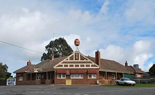
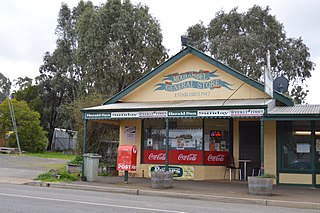
Cape Clear is a small town located in Victoria, Australia. Cape Clear has a hotel and a general store. The town is close to the Woady Yaloak River. The area was once vibrant during the gold rush in the 19th century with the area swamping to 25,000 people during the height of the gold rush with the local population being lower than 1,000. Cape Clear Post Office opened on 17 April 1865. and still ran and owned by the same family. It is now largely dependent on farming.

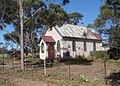
Lamplough is a locality near Avoca, Victoria in Australia. It was the site of a gold rush from November 1859 and up to 16,000 people were on the site. The lead was worked for a distance of nearly 3 miles (5 km) to the point where it ran into the water and was abandoned.
Joel Joel is a locality in the Shire of Northern Grampians, 23 km east of Stawell in the Wimmera region of Victoria, Australia.
Bung Bong is a locality in Victoria between the towns of Avoca and Maryborough. The locality is divided, with the Western section in the Pyrenees Shire and the Eastern section in Shire of Central Goldfields. The Bet Bet Creek runs towards the north through the middle of the locality and then into the Loddon River. Bung Bong is located on the Pyrenees Highway.

Mullengandra is a village community in the south east part of the Riverina. It is situated by road, about 7 kilometres north east of Bowna and 8 kilometres south west of Woomargama. The town is on the Hume Highway north of Albury.

Quambatook is a town in northern Victoria, Australia.

Learmonth is a town, located in Central Victoria, Australia, 136 kilometres (85 mi) west of the state capital Melbourne, and 23 kilometres north west of the regional city centre of Ballarat. Learmonth is located on the Sunraysia Highway, on the road to Avoca, St Arnaud and the Pyrenees wine region, and is surrounded by an agricultural, pastoral and dairy region. At the 2021 census, Learmonth had a population of 396.

Barkly is a locality in Victoria, Australia, about 180 kilometres (110 mi) northwest of Melbourne. It is near the intersection of the road from Landsborough to Redbank, and the road from Frenchmans to St Arnaud. It is close to the west boundary of the St Arnaud Range National Park. It is located in the Pyrenees Shire. At the 2016 census Barkly had a population of 43.
Nareewillock is a locality in the Lower Avoca ward of the local government area of the Shire of Buloke, Victoria, Australia.
Teddywaddy is a locality in the Lower Avoca ward of the local government area of the Shire of Buloke, Victoria, Australia. A rural CFA station is located on 'Lot 1 Teddywaddy Road.'
Moonambel is a town in the Pyrenees region of the Australian state of Victoria, situated along the Stawell-Avoca Road [about 8 kilometres (5.0 mi) from the junction with the Sunraysia Highway]. The town is located in the Pyrenees Shire Local Government Area, near the heart of the Pyrenees wine region. The name 'Moonambel' is believed to be an aboriginal word meaning 'hollow in the hills'.

Rathscar is a locality in Pyrenees Shire and the Shire of Central Goldfields. The area to the east of the Avoca River known as Rathscar West was surveyed in 1899.