
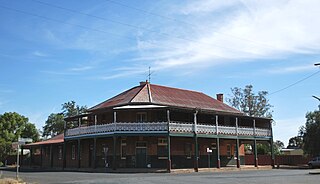
Harden–Murrumburrah is a town and community in the Hilltops Region and is located in the South West Slopes of New South Wales in Australia. Harden is adjacent to both the Canberra region of the Australian Capital Territory and the Riverina Region in the southwest area of NSW. The town is a twin town between Harden and Murrumburrah.

Warracknabeal is a town in the Australian state of Victoria, located in the Victorian wheatbelt. Situated on the banks of the Yarriambiack Creek, 330 km northwest of Melbourne, it is the business and services centre of the northern Wimmera and southern Mallee districts, and hosts local government offices of the Shire of Yarriambiack. At the 2021 census, the Warracknabeal township had a population of 2,359.

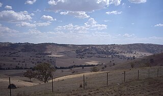
Wallendbeen is a small town in southern New South Wales, Australia, administered by Cootamundra-Gundagai Regional Council. At the 2011 census, Wallendbeen and the surrounding area had a population of 305. The town's name is derived from an aboriginal word for "stony hill".

Patchewollock is a town in north-west Victoria, Australia. At the 2021 census, Patchewollock had a population of 149.
Yerong Creek is a town in the Riverina area of southern New South Wales, Australia. It is about 46 kilometres (29 mi) south-west of Wagga Wagga on the Olympic Highway. At the 2016 census, Yerong Creek had a population of 173.

Burraboi is a community in New South Wales, Australia. It is in the southwestern part of the Riverina, about 34 kilometres (21 mi) north of Barham and 50 km south of Moulamein. At the 2016 census, Burraboi had a population of 63.
Gobarralong is a rural community in the central east part of the Riverina, Australia. It is situated about 16 kilometres southeast of Coolac and 27 kilometres northwest of Adjungbilly. At the 2016 census, Gobarralong and the surrounding area had a population of 52 people.
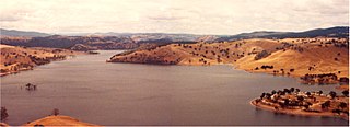
Woolgarlo is a locality on the foreshores of the Yass River arm of Lake Burrinjuck, in the far eastern part of the Riverina in the Yass Valley Shire of New South Wales, Australia. At the 2016 census, it had a population of 26.

Mullengandra is a village community in the south east part of the Riverina. It is situated by road, about 7 kilometres north east of Bowna and 8 kilometres south west of Woomargama. The town is on the Hume Highway north of Albury.

Wymah is a rural community in the south-east part of the Riverina very close to the border of Victoria, Australia. It is situated by road, about 11 kilometres (7 mi) south of Bowna and 23 kilometres (14 mi) west of Talmalmo. Wymah is situated on the Wymah River Road accessible from Bowna. At the 2016 census, Wymah had a population of 37.

Springdale is a village community in the central north part of the Riverina region of the Australian state of New South Wales. It is situated by road, about 3 kilometres east of Combaning and 23 kilometres north west of Stockinbingal. At the 2016 census, it had a population of 150.
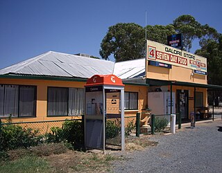
Galore is a rural community in the central east part of the Riverina. It is situated by road, about 22 kilometres north west of Collingullie and 28 kilometres south east of Sandigo. At the 2016 census, Galore had a population of 95 people.

Piangil, once frequently spelled "Pyangil", is a town in the Mallee region of northern Victoria, Australia. It is approximately 382 kilometres (237 mi) north west of the state capital, Melbourne and 46 kilometres (29 mi) north west of the regional centre of Swan Hill. At the 2016 census, Piangil and the surrounding rural area had a population of 259.
Peranga is a rural town and locality in the Toowoomba Region, Queensland, Australia. In the 2021 census, the locality of Peranga had a population of 98 people.

Delungra is a small town on the Gwydir Highway, 33 kilometres (21 mi) from Inverell and 43 kilometres (27 mi) from Bingara in Inverell Shire, New South Wales, Australia. At the 2016 census, Delungra and the surrounding area had a population of 647. The urban centre had a population of 285.

Merbein South is a locality in Victoria, Australia, located approximately 16 kilometres (9.9 mi) from Mildura. At the 2016 census, Merbein South had a population of 405.
Waitchie is a locality in Victoria, Australia, located approximately 44 km (27 mi) from Swan Hill, Victoria. At the 2006 census, Waitchie had a population of 118, decreasing to 48 at the 2016 census.
Tresco is a locality in Victoria, Australia, located approximately 23 km from Swan Hill. It was named after Tresco, Isles of Scilly, England. At the 2016 census, Tresco had a population of 209.

Glengarry is a town in the Gippsland region of Victoria, Australia. The town is located in the City of Latrobe local government area, 165 kilometres (103 mi) south east of the state capital, Melbourne. At the 2016 census, Glengarry had a population of 1084.
Tyntynder is a locality in the south-east of the Mallee region of Victoria, Australia. Tyntynder Football Club is an Australian rules football team in the Central Murray Football League.


