Crystal Brook, South Australia

Last updated

Crystal Brook
South Australia
CrystalBrookSilos.jpg
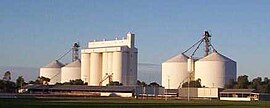
The rising sun catching the Crystal Brook grain silos on a clear winter's morning; the town sports oval in the foreground
Australia South Australia location map.svg
Red pog.svg
Crystal Brook
Coordinates 33°21′0″S138°12′0″E / 33.35000°S 138.20000°E / -33.35000; 138.20000 Coordinates: 33°21′0″S138°12′0″E / 33.35000°S 138.20000°E / -33.35000; 138.20000
Population1,935 (2016 census) [1]
Established1873
Postcode(s) 5523
Elevation115 m (377 ft) [2]
Location
LGA(s) Port Pirie Regional Council
Region Mid North
County Southern Flinders Ranges
State electorate(s) Frome
Federal division(s) Grey
Mean max tempMean min tempAnnual rainfall
24 °C
75 °F
6 °C
43 °F
445 mm
17.5 in
Localities around Crystal Brook:
Warnertown Beetaloo Valley Gladstone
Nurom
Wandearah East
Crystal Brook Huddleston
Narridy
Merriton Redhill Koolunga

Crystal Brook is a town in the Mid North of South Australia, 197 kilometres north of the capital, Adelaide. In 2016, the population of the town/postcode was 1,935. [3] Crystal Brook is in a very picturesque location, being at the start of the Flinders Ranges. The town has multiple viewing points and parks. It was named after the spring-fed creek next to which it was founded.

Contents

Crystal Brook is the second largest town after the city of Port Pirie in the Southern Flinders Ranges area. The shady peppercorn trees grace the main street, Bowman Street. The area where the present town is now was founded in 1839 by Edward John Eyre who was passing through the region. He named it after the beautiful sparkling clear water and named it 'Chrystal Brook'. [4]

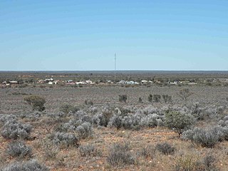
Crystal Brook is 197 kilometres (122 mi) north of Adelaide. The town has had some growth over the past year or two with more proposed job opportunities in the region. Crystal Brook is situated on Goyder's Line near the border of two climate systems. The township of Crystal Brook is surrounded by an intense farming region. As the town has experienced some growth in the past few years it has pushed housing development to the western side of the original township and across the creek.

The town benefits from a temperate mediterranean climate zone, [5] making possible slightly more intense farming in the region. To the south to south-east and west lies more intense farming and to the north-west lies some marginal, semi-arid farmland.

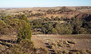
It is home to nearby Bowman Park , a nature preserve that is situated in the Crystal Brook Valley and has an abundance of wildlife and shady camping spots right next to the Crystal Brook Creek. The park contains history that dated back to the 1800s. The original homestead that belonged to the Bowman Brothers, which the park was named after, is there overlooking the Crystal Brook.

Summers in Crystal Brook are warm to hot and can be mostly dry . Winters are wet and cold with day time temps reaching just average 13 degrees Celsius or less and night time temps around 5 degrees Celsius. Many days are overcast and drizzle.

History

The administrative land division the Hundred of Crystal Brook was proclaimed in 1871 in the vicinity of the confluence of the Rocky River and Broughton River. The township, near the eponymous Broughton River tributary, Crystal Brook, was surveyed in August 1874 and officially proclaimed on 12 November that year. [6]

Local government

The District Council of Crystal Brook was established in 1882. It amalgamated with the District Council of Redhill in 1988 to form the District Council of Crystal Brook-Redhill which continued to be seated at Crystal Brook. From 1997 Crystal Brook has been locally governed by the Port Pirie Regional Council following a merger between Crystal Brook-Redhill and the Port Pirie City councils.

Military history

During World War II, Crystal Brook was the location of RAAF No.31 Inland Aircraft Fuel Depot (IAFD), built in 1942 and closed on 14 June 1944. Usually consisting of 4 tanks, 31 fuel depots were built across Australia for the storage and supply of aircraft fuel for the RAAF and the US Army Air Forces at a total cost of £900,000 ($1,800,000). [7]

Infrastructure

Water

Crystal Brook (or creek) supplied water to the town until 1890 when the Beetaloo Reservoir was completed, which at the time was the largest concrete dam in the southern hemisphere. [8]

Broadband

Broadband internet became available at Crystal Brook on 16 April 2005 after lobbying from residents. Both ADSL and ADSL2+ speeds are available to residential and business customers. National Broadband Network (NBN) wired services for the township became available on 7 October 2016. The old ADSL and PSTN infrastructure is expected to be turned off about 13 April 2018. Free WI-FI is provided by the local council in the main street, for the use of travelers and locals. NBN wireless broadband and satellite is available outside of the township area.

Transport

Crystal Brook serves as a major junction on the Sydney–Perth and the Adelaide–Darwin railway lines, both sharing the same approximately 530 kilometres (329 mi) of track between Crystal Brook and Tarcoola. There is a triangular junction at Crystal Brook which joins Tarcoola, Adelaide and Sydney and sees regular trains each day in all directions.

Entertainment and tourism

Crystal Brook Show

The Crystal Brook Show has been held annually since the early 1880s. The 2020 and 2021 show has been cancelled due to COVID-19 social distancing requirements. [9]

Heysen Trail

The town lies on the Heysen Trail, a 1,200 kilometres (746 mi)-long walking trail from Cape Jervis to Parachilna Gorge.

Close to the north–south midpoint of the trail, Crystal Brook marks a change in climate. Hot, dry summers and mild winters lie to the north, and more temperate conditions to the south. [10]

Sport

Crystal Brook's sporting facilities cater for hockey, tennis, croquet, golf, lawn bowls, netball, basketball, swimming, gymnasium exercise, junior soccer, horse riding, motor-cross, football and cricket.

In regional competitions the town colours are red and white, with most teams known as 'The Roosters'.

The Crystal Brook Football Club won the Northern Areas (Australian Rules) Football Association premiership for a record 19th time in 2012 [11] and the town has twice staged a round of the Australian motor-cross championships.

Notable people

Related Research Articles

Heysen Trail Long-distance trail in Australia

The Heysen Trail is a long distance walking trail in South Australia. It runs from Parachilna Gorge, in the Flinders Ranges via the Adelaide Hills to Cape Jervis on the Fleurieu Peninsula and is approximately 1,200 kilometres (750 mi) in length.

Port Pirie City in South Australia

Port Pirie is a small city on the east coast of the Spencer Gulf in South Australia, 223 km (139 mi) north of the state capital, Adelaide. The city has an expansive history which dates back to 1845. Port Pirie was the first proclaimed regional city in South Australia and is currently the second most important and second busiest port in the state.

Bowman Park

Bowman Park is a public park in South Australia located on the Crystal Brook about 5 km northeast of the township of Crystal Brook and 200 km north of the capital city of Adelaide. The park has an area of about 40ha and is in the Mid North region of the state of South Australia, and named for the Bowman Brothers who settled in the area around 1850.

Flinders Ranges Mountain range in South Australia

The Flinders Ranges are the largest mountain range in South Australia, which starts about 200 km (125 mi) north of Adelaide. The discontinuous ranges stretch for over 430 km (265 mi) from Port Pirie to Lake Callabonna. The Adnyamathanha people are the Aboriginal group who have inhabited the range for tens of thousands of years.

Rail transport in South Australia

The first railway in colonial South Australia was a line from the port of Goolwa on the River Murray to an ocean harbour at Port Elliot, which first operated in December 1853, before its completion in May 1854.

Laura is a rural town in the Mid North region of South Australia, 12 km north of Gladstone on the Horrocks Highway and 40 km east of Port Pirie. The first European to explore the district was Thomas Burr in September 1842. His promising reports soon led to occupation of the district by pastoralists, one of whom was Herbert Bristow Hughes. When the present town was surveyed he named it for his wife, Laura née White.

Tarcoola railway station Railway station in South Australia

Tarcoola railway station is a railway station in the Australian state of South Australia located on the Trans-Australian Railway in the state's west. It serves the town of Tarcoola and is the northern junction of the Sydney-Perth and Adelaide-Darwin railways, which share approximately 530 kilometres (329 mi) of track between Tarcoola and Crystal Brook.

Tarcoola, South Australia Town in South Australia

Tarcoola is a town in the Far North of South Australia 416 kilometres (258 mi) north-northwest of Port Augusta. At the 2016 census, Tarcoola had no people living within its boundaries.

Port Pirie Regional Council Local government area in South Australia

The Port Pirie Regional Council (PPRC) is a local government area in South Australia, focused on the city of Port Pirie. It has a population of about 18,000 people. The council's main administrative facilities and works depot can be found in Port Pirie; it also have a rural office in Crystal Brook. In addition to Port Pirie, the municipality also includes the surrounding towns and localities of Bungama, Collinsfield, Coonamia, Crystal Brook, Koolunga, Lower Broughton, Merriton, Napperby, Nelshaby, Pirie East, Port Davis, Port Pirie South, Port Pirie West, Redhill, Risdon Park, Risdon Park South, Solomontown, Wandearah East, Wandearah West and Warnertown, and part of Clements Gap, and Mundoora.

Meningie, South Australia Town in South Australia

Meningie is a town on the south-east side of Lake Albert in South Australia. It is on the Princes Highway near The Coorong and was surveyed in 1866. At the 2016 census, the locality of Meningie had a population of 1118 with a median age of 51 while its town centre had a population of 852.

Redhill, South Australia Town in South Australia

Redhill is a town in the Mid North of South Australia adjacent to the Broughton River.

The Adelaide-Port Augusta railway line is the main route for northbound rail traffic out of Adelaide, South Australia. The line, 315 kilometres long, is part of the Adelaide–Darwin rail corridor and the Sydney–Perth rail corridor.

Rocky River was an electoral district of the House of Assembly in the Australian state of South Australia from March 1938 to December 1985.

The District Council of Crystal Brook was a local government area in South Australia from 1882 until 1988, seated at Crystal Brook.

The District Council of Crystal Brook-Redhill was a local government area in South Australia.

The District Council of Redhill was a local government area in South Australia from 1888 to 1988.

Hundred of Crystal Brook Cadastral in South Australia

The Hundred of Crystal Brook is a cadastral unit of hundred located in the Mid North of South Australia in the approach to the lower Flinders Ranges. It is one of the hundreds of the County of Victoria and was named by Governor James Fergusson after the stream of the same name which flows east to west near the northern border of the hundred.

The Hundred of Redhill is a cadastral unit of hundred located in the Mid North of South Australia spanning the northern Barunga Range. It is one of the 16 hundreds of the County of Daly and was named in 1869 by Governor James Fergusson after the same hill giving rise to the name for the township of Redhill, uphill from the west bank of the Broughton River.

The Flinders News is a weekly newspaper published in Port Pirie, South Australia, formed from the historic mergers of multiple Mid-North publications and representing a combined ancestry of 12 former publications. Its earliest constituent publication, the Northern Mail, was first issued on 30 June 1876, and the newspaper has been published under its current title since 1989. It was later sold to Rural Press, previously owned by Fairfax Media, but now an Australian media company trading as Australian Community Media.

References

  1. Australian Bureau of Statistics (27 June 2017). "Crystal Brook (Urban Centre/Locality)". 2016 Census QuickStats. Retrieved 31 January 2020. OOjs UI icon edit-ltr-progressive.svg
  2. South Australian Rail Public timetable 1963, pg3
  3. "2016 Census QuickStats: 5523, SA". quickstats.censusdata.abs.gov.au. Retrieved 13 April 2021.
  4. Smart, Liz (27 August 2019). "Crystal Brook, SA". Aussie Towns. Retrieved 15 January 2020.
  5. The Köppen climate classification system classifies the north of the Crystal Brook region as BSk, or cold semi-arid, and the bordering region to the east as Csb, or temperate mediterranean
  6. "Placename Details: Crystal Brook". Government of South Australia. SA0017046. Archived from the original on 7 December 2015. Retrieved 22 January 2019. Town surveyed in August 1874. Boundaries created in April 2001 for long established name. Incorporates the Government Town of Crystal Brook.
  7. Australia. Royal Australian Air Force. Historical Section (1995), Logistics units, AGPS Press, ISBN   978-0-644-42798-2
  8. "Beetaloo beauty celebrates local connection to culture". SA Water. 10 July 2019. Retrieved 15 August 2021.
  9. The Maitland Mercury (8 Sep 1883) quotes a Sydney 'Evening News' report that the (South Australian) Governor and Commissioner for Crown Lands departed Adelaide to attend the Crystal Brook Show
  10. Heysen Trail Archived 23 May 2009 at the Wayback Machine The South Australian Government's Department for Environment and Heritage (includes a map)
  11. Northern Areas Football Association List of Premiers Archived 29 June 2008 at the Wayback Machine from 1909 onwards