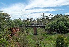
Port Pirie is a small city on the east coast of the Spencer Gulf in South Australia, 223 km (139 mi) north of the state capital, Adelaide. The city has an expansive history which dates back to 1845. Port Pirie was the first proclaimed regional city in South Australia and is currently the second most important and second busiest port in the state.

Crystal Brook is a town in the Mid North of South Australia, 197 kilometres north of the capital, Adelaide. In 2016, the population of the town/postcode was 1,935. Crystal Brook is in a very picturesque location, being at the start of the Flinders Ranges. The town has multiple viewing points and parks. It was named after the spring-fed creek next to which it was founded.
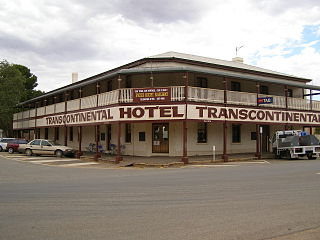
Quorn is a small town and railhead in the Flinders Ranges in the north of South Australia, 39 kilometres (24 mi) northeast of Port Augusta. At the 2016 census, the locality had a population of 1,230, of which 1,131 lived in its town centre.

Gladstone is a small rural town in the Mid North of South Australia in the approach to the lower Flinders Ranges. At the 2006 census, Gladstone had a population of 629.

Peterborough is a town in the mid north of South Australia, in wheat country, just off the Barrier Highway. At the 2016 census, Peterborough had a population of 1,419. It was originally named Petersburg after the landowner, Peter Doecke, who sold land to create the town. It was one of 69 places in South Australia renamed in 1917 due to anti-German sentiments during World War I.

Snowtown is a town located in the Mid North of South Australia 145 km north of Adelaide and lies on the main road and rail routes between Adelaide and Perth – the Augusta Highway and Adelaide-Port Augusta railway line. The town's elevation is 103 metres and on average the town receives 389 mm of rainfall per annum.
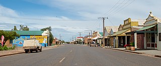
Terowie is a small town in the Mid North region of South Australia located 220 kilometres (137 mi) north of the state capital of Adelaide. It is located in the Regional Council of Goyder. Terowie retains a number of authentic and well preserved 1880s buildings, and has been declared a "historic town". It also remains a town of interest to those interested in rail history. Although now a very small town with few facilities, Terowie remains a popular destination for photographers, historians, and rail buffs. At the 2016 census, Terowie had a population of 131.

The first railway in colonial South Australia was a line from the port of Goolwa on the River Murray to an ocean harbour at Port Elliot, which first operated in December 1853, before its completion in May 1854.

Port Broughton is a small South Australian town located at the northern extent of the Yorke Peninsula on the east coast of Spencer Gulf. It is situated about 170 km north-west of Adelaide, and 56 km south of Port Pirie. At the 2011 census, the town of Port Broughton had a population of 1,034.
Bowmans is a locality in South Australia's Mid North. At the 2006 census, Bowmans had a population of 203. It is named after R and C Bowman who were "pastoralists in area."

Port Germein is a small sea-side town in the Australian state of South Australia located about 219 kilometres (136 mi) north of the state capital of Adelaide and about 19 kilometres (12 mi) north of the city of Port Pirie on the eastern side of South Australia's Spencer Gulf overlooking Germein Bay. Port Germein was named after Samuel Germein, who moved into the territory in 1840, although some credit his brother John to be the first European to traverse the area. The township was proclaimed in 1878. Port Germein's population in the 2006 census was 249.
The Adelaide-Port Augusta railway line is the main route for northbound rail traffic out of Adelaide, South Australia. The line, 315 kilometres long, is part of the Adelaide–Darwin rail corridor and the Sydney–Perth rail corridor.
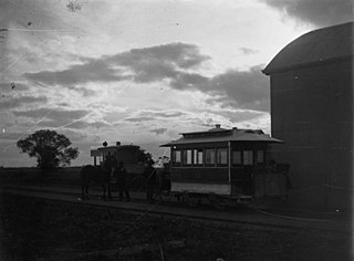
Mundoora is a settlement in South Australia, 16 km inland from Port Broughton, to which it was connected by the horse-drawn Port Broughton tramway around 1876. Its tram, dubbed "The Pie Cart", which was described as a "kind of second-hand coffin drawn by one horse" and still in operation in 1923 was later relegated to the Railways Museum and the line dismantled. At the 2006 census, Mundoora had a population of 248.
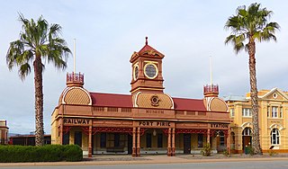
Ellen Street railway station was the second of six stations that operated successively between 1875 and the early 2010s to serve the rural maritime town of Port Pirie, 216 km (134 mi) by rail north of Adelaide, South Australia. Soon after construction of the line towards Gladstone began in 1875, an impromptu passenger service commenced. The inaugural station, Port Pirie South, was 800 metres from the centre of the town. Since two tracks had already been laid down the middle of Ellen Street to the wharves, a small corrugated iron shed was erected as a ticket and parcels office. The street-side location was unusual for the South Australian Railways. In 1902, when passenger traffic had increased greatly, a stone building was erected in a striking Victorian Pavilion style. After the tracks were removed in 1967 and the station closed, the building's design assured its retention as a museum of the National Trust of South Australia.

Port Pirie railway station was the fifth of six stations that operated at various times from 1876 to serve the small maritime town of Port Pirie, 216 kilometres by rail north of Adelaide, South Australia. As with several of Port Pirie's other stations before it, the station was built to accommodate a change of track gauge on railway lines leading into the town.

Oodla Wirra is a small town in the upper Mid North of South Australia. It is on the Barrier Highway approximately halfway from Adelaide to Broken Hill.
The District Council of Crystal Brook was a local government area in South Australia from 1882 until 1988, seated at Crystal Brook.
The District Council of Redhill was a local government area in South Australia from 1888 to 1988.
The District Council of Port Broughton was a local government area in South Australia from 1892 to 1997 seated at the town of Port Broughton.
George Frederick Claridge was a South Australian businessman and philanthropist, longtime chairman of the Home for Incurables.
