
Port Augusta is a small city in South Australia. Formerly a seaport, it is now a road traffic and railway junction city mainly located on the east coast of the Spencer Gulf immediately south of the gulf's head and about 322 kilometres (200 mi) north of the state capital, Adelaide. The suburb of Port Augusta West is located on the west side of the gulf on the Eyre Peninsula. Other major industries included, up until the mid-2010s, electricity generation. At June 2018, the estimated urban population was 13,799, having declined at an average annual rate of -0.53% over the preceding five years.

Port Pirie is a city and seaport on the east coast of the Spencer Gulf in South Australia, 223 km (139 mi) north of the state capital, Adelaide. The settlement was founded in 1845 and at June 2018 had an estimated urban population of 14,188. Port Pirie is the eighth most populous city in South Australia after Adelaide, Mount Gambier, Gawler, Mount Barker, Whyalla, Murray Bridge, and Port Lincoln.

Gawler is the oldest country town on the Australian mainland in the state of South Australia. It was named after the second Governor of the colony of South Australia, George Gawler. It is about 40–44 km (25–27 mi) north of the centre of the state capital, Adelaide, and is close to the major wine producing district of the Barossa Valley. Topographically, Gawler lies at the confluence of two tributaries of the Gawler River, the North and South Para rivers, where they emerge from a range of low hills.

Adelaide Railway Station is the central terminus of the Adelaide Metro railway system. All lines approach the station from the west, and it is a terminal station with no through lines, with most of the traffic on the metropolitan network either departing or terminating here. It has nine platforms, all using broad gauge track. It is located on the north side of North Terrace, west of Parliament House. The Adelaide Casino occupies part of the building that is no longer required for railway use. Until 1984, Adelaide station was also the terminus for regional and interstate passenger trains, but there are no longer any regular regional train services in South Australia, and all interstate services are now handled at Adelaide Parklands Terminal.

Crystal Brook is a town in the Mid North of South Australia, 197 kilometres north of the capital, Adelaide. It was named after the spring-fed creek next to which it was founded. In 2016 the population of the agricultural town was 1,515. Crystal Brook is the second largest town after the city of Port Pirie in the Southern Flinders Ranges area. The shady peppercorn trees grace the main street, Bowman Street. The area where the present town is now was founded in 1839 by Edward John Eyre who was passing through the region. He named it after the beautiful sparkling clear water and named it 'Chrystal Brook'.

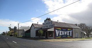
Gladstone is a small rural town in the Mid North of South Australia in the approach to the lower Flinders Ranges. At the 2006 census, Gladstone had a population of 629.

The rail network in Adelaide, South Australia, consists of six lines and 89 stations, totalling 132 km. It is operated by Adelaide Metro, and is part of the citywide Adelaide Metro public transport system.

The first railway in colonial South Australia was a horse-drawn tramway from the port of Goolwa on the Murray River to an ocean harbour at Port Elliot in 1854. Today the state has 1,600 mm broad gauge suburban railways in Adelaide, a number of country freight lines, as well as key 1,435 mm standard gauge links to other states.

The Trans-Australian Railway, opened in 1917, runs from Port Augusta in South Australia to Kalgoorlie in Western Australia, crossing the Nullarbor Plain in the process. As the only rail freight corridor between Western Australia and the eastern states, the line is strategically important. The railway includes the world's longest section of completely straight track.

The Gawler railway line is a suburban commuter railway line in the city of Adelaide, South Australia. It is the only rail route in Adelaide to have no interchange with another line at any station except Adelaide.

The Commonwealth Railways were established in 1917 by the Government of Australia with the Commonwealth Railways Act to administer the Trans-Australia and Port Augusta to Darwin railways. It was absorbed into Australian National in 1975.
Wolseley is a small South Australian town near the Victorian border. It is five kilometres south of the Dukes Highway and 13 kilometres east of Bordertown. It was first proclaimed a town in 1884.

Salisbury railway station is a railway station and bus interchange in the northern Adelaide suburb of Salisbury. It is on the Gawler line, 20.2 kilometres (12.6 mi) from Adelaide station. Adjoining it is a large park & ride carpark, making it one of the busiest stations on the Adelaide suburban rail system.
The Adelaide-Port Augusta railway line is the primary rail corridor in South Australia for northbound rail traffic out of Adelaide. The line forms part of the Perth–Adelaide and Adelaide–Darwin rail route, and the portion south of Crystal Brook forms part of the Adelaide–Sydney rail route.
Port Pirie Junction railway station was located in the city of Port Pirie.
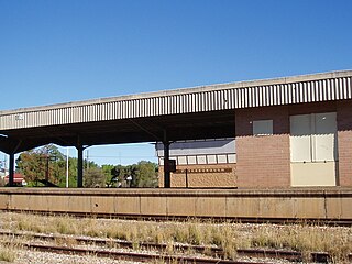
Peterborough railway station is located on the Crystal Brook-Broken Hill line in Peterborough, South Australia.
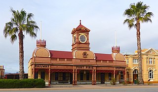
Ellen Street railway station was the second of six stations that operated successively between 1876 and the early 2010s to serve the rural maritime town of Port Pirie, 216 km (134 mi) by rail north of Adelaide, South Australia. Prompted by the need to have a station closer to the centre of the town than Port Pirie's inaugural station, it was opened in 1902 as a terminus for passenger trains on the main street. The railway was already present there – an unusual location in Australia. The striking Victorian Pavilion style of the building was unique on the South Australian Railways, and this factor assured its retention after closure as a museum of the National Trust of South Australia.
Port Pirie railway station may refer to one of the following railway stations in Port Pirie, South Australia:

Solomontown railway station was one of a total of six stations that operated at various times between 1876 and the early 2010s to serve the rural maritime town of Port Pirie, 216 km (134 mi) by rail north of Adelaide, South Australia. It was opened in 1911 as the town's third narrow-gauge "station" – in practice an unattended provisional stopping place. It was closed in 1967.

Oodla Wirra is a small town in the upper Mid North of South Australia. It is on the Barrier Highway approximately halfway from Adelaide to Broken Hill.
