The inaugural passenger train service was known as the Great Western Express; later, it became the Trans-Australian. As of 2020[update], two passenger services use the line, both of them experiential tourism services: the Indian Pacific for the entire length of the railway, and The Ghan between Port Augusta and Tarcoola, where it leaves the line to proceed north to Darwin.
History
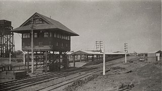
The single-track Trans-Australian Railway at Cook, once a major station and servicing point
In 1901, the six Australian colonies federated to form the Commonwealth of Australia. At that time, Perth, the capital of Western Australia, was isolated from the remaining Australian states by thousands of miles of desert terrain and the only practicable method of transport was by sea. The voyage across the notoriously rough Great Australian Bight was time-consuming, inconvenient and often uncomfortable. One of the inducements held out to Western Australians to join the new federation was the promise of a federally funded railway line linking Western Australia with the rest of the continent.[1]
In 1907, legislation was passed, allowing for the route to be surveyed. The survey, completed in 1909, endorsed a route from Port Augusta (the existing railhead at the head of Spencer Gulf in South Australia's wheatfields) via Tarcoola to the gold mining centre of Kalgoorlie in Western Australia, a distance of 1,063 miles (1,711km). The line was to be built to the standard gauge of 4ft8+1⁄2in (1,435mm), even though the state railway systems at both ends were narrow gauge at the time. Its cost was estimated at £4,045,000.
Work proceeded eastwards from Kalgoorlie and westwards from Port Augusta through the years of the First World War. Tracklaying proceeded briskly when materials were available. At its peak, up to 2+1⁄2 miles (4.0km) of track were laid each day, and 442 miles (711km) were completed in one calendar year – both Australian tracklaying records.[2] By 1915, the two ends of the line were just over 600 miles (966km) apart with materials being delivered daily.[3] Construction progressed steadily as the line was extended through mainly dry and desolate regions until the two halves of the line met at Ooldea on 17 October 1917.[4][5]
Under the aegis of the federal department of transport, the Commonwealth Railways was established in 1917 to operate the line. Once passenger trains started to run, maintenance staff found that the high mineral salt content of bore water available along the route was playing havoc with steam locomotiveboilers: repairs to boilers at one time accounted for an extraordinary 87per cent of all locomotive maintenance. The problem was only arrested with the introduction of barium carbonatewater treatment plants at watering points.[6]
In 1937, the eastern end was extended 90 kilometres (56 miles) south to Port Pirie. Soon afterwards, the South Australian Railways extended its 1,600mm (5ft3in) broad-gauge line 47km (29mi) north to Port Pirie from Redhill. These two projects made redundant the indirect 290 kilometres (180 miles), 1,067mm (3ft6in) narrow-gauge connection from Terowie via Peterborough and Quorn, resulting in a much shorter and more comfortable journey to Adelaide. These two projects eliminated one break of gauge in the journey across Australia, but they turned Port Pirie Junction yard into a complex three-gauge facility.[7]:109 Railway engineers, however, were able to construct the new yards with no more than minimal dual-gauge track and the complex signalling that would have been incurred.[8]:25–26
The long-anticipated conversion of the entire line between Sydney and Perth to standard gauge occurred in 1970.
In 2004, the gap in standard gauge connections between the mainland state capitals was finally closed with a connection between Port Pirie and Adelaide, thence Melbourne, and by completion of the northern component of the Adelaide–Darwin railway line, which diverges from the Trans–Australian Railway at Tarcoola.
In 2008, the engineering heritage of the railway was recognised by the Engineering Heritage Recognition Program of Engineers Australia when markers were installed on the platform at the Port Augusta station in South Australia and the ticket office at Kalgoorlie station in Western Australia.[9]
On 17 October 2017, centenary celebrations were held at Ooldea.[10]
Named services
When the line was inaugurated, the passenger service was named as the Great Western Express.[11] Later, the train became known as the Trans-Australian or, colloquially, "The Trans". After the Sydney–Perth route was converted to standard gauge in 1970, the railway was no longer flanked at both ends by narrow-gauge lines and an all-through service, called the Indian Pacific, was started. Although passengers no longer had to move to different carriages at change-of-gauge localities, Commonwealth Railways remained responsible for the service where it operated between Port Pirie and Kalgoorlie, with its crews and locomotives taking over at those stations. In 1975, Commonwealth Railways was absorbed into an enlarged federal government corporation, Australian National Railways Commission, branded as Australian National Railways and later as "Australian National", which continued to operate the Trans Australian.[12] In 1993, Australian National took over operation of the entire coast-to-coast service following agreement with the governments of Western Australia and New South Wales.[13]
From the start of construction until 1996, the Tea and Sugar supply train carried vital provisions to the work sites and localities, all of them isolated, along the route: a butcher and banking and postal services were among the facilities provided.
Terrain
The length of the line, as constructed, was 1051.73mi (1692.60km), slightly less than the original survey.
Although there are several hundred curves and gradients on the line, the route includes the longest length of straight track in the world – 478.193 kilometres (297.135 miles).[note 1] A Commonwealth Railways map marked the western end as 793 miles (1,276km) from Port Augusta, between Loongana and Nurina, and states: "The 'Long Straight' extends from this point for a distance of 297 miles and terminates at the 496 miles [sic] between Ooldea and Watson."[note 2]
According to South Australian astronaut Andy Thomas, the line is identifiable from space because of its unnatural straightness: "It's a very fine line, it's like someone has drawn a very fine pencil line across the desert".[19]
At no point along the route does the line cross a permanent fresh watercourse. Bores and reservoirs were established at intervals, but the water was often brackish and unsuitable for steam locomotive use, let alone human consumption, so water supplies had to be carried on the train. In the days of steam locomotion, about half the total load was water for the engine. In later years, condenser plants were built at several major stations.[citation needed]
A map on one side of a leaflet provided to passengers showing all localities on the Trans-Australian Railway at the time and the origins of their names (click to enlarge)
Reflecting the line's ownership by the Commonwealth Government, eight of the localities were named (or renamed) after Australian Prime Ministers. Other prominent people's names were also allocated, as shown on the adjacent map.
Operations
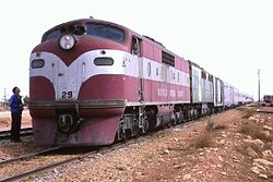
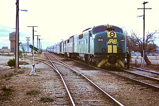
The Trans-Australian proceeding from Port Pirie Junction to Port Augusta and Western Australia in 1938, soon after the Trans-Australian Railway was extended to Port PirieIn 1986 the Trans-Australian at Rawlinna, WA is bound for Port Pirie. It would be another 18 years before all mainland state capitals were connected by standard gauge tracks.
Because of the inevitable problems of finding suitable water for steam locomotives in a desert, the original engineer, Henry Deane envisaged diesel locomotives for the line and made inquiries with potential manufacturers, although the technology was not well developed at the time. Unfortunately, a scandal involving the supply of sleepers led to Deane's resignation before the proposal had advanced.[20][pageneeded]
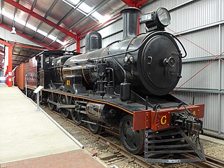
Initially trains were hauled by G class locomotives and from 1938 by C class locomotives, both steam.[21] From 1951, diesel-electric locomotives hauled passenger services, using the new GM class locomotives.[22]
The railway originally had 400m (1,300ft)-long crossing loops (passing sidings) every 100km (62mi) or so. As traffic increased the number of crossing loops increased. To handle longer trains, crossing loops were lengthened so that in 2008 they were all at least 1,800m (5,900ft) long and spaced about 30km (19mi) to 60km (37mi) apart.[23]
Most crossing loops are unattended and train crew operate the turnouts as required. Crossing loops have self-restoring points, so that points are reset to the straight route when a train departs from a crossing loop. The loops are fitted with radio controls so that train crew can set the points as they approach. Locomotive cabs are fitted with an activated points system (ICAPS) to set the required route without having to stop the train.[24]
In the time of the operation of the railway, 'washaways' and 'flooding' in most cases rendered the railway inoperable at a range of locations. Washaways usually removed ballast, leaving rails suspended above the flooding areas.
In most cases the underlying ballast was removed, and required replacing. Significant events on the line were in 1921, 1930 1937 and 2022,[25]. The 1930 flooding had two trains held up on sections of the line.[26][27][28][29]
Notes
↑ In the original survey of the track in the early 1900s, the length was recorded as 297 miles, 8.5 chains – equating to 478.147 kilometres (297.107 miles). In 1990, using recently acquired Global Positioning System (GPS) capabilities, Geoscience Australia measured the length as 478.193 kilometres, a difference of only 46 metres (50 yards).[16]
The Indian Pacific is a weekly experiential tourism passenger train service that runs in Australia's east–west rail corridor between Sydney, on the shore of the Pacific Ocean, and Perth, on the shore of the Indian Ocean – thus, like its counterpart in the north–south corridor, The Ghan, one of the few truly transcontinental trains in the world. It first ran in 1970 after the completion of gauge conversion projects in South Australia and Western Australia, enabling for the first time a cross-continental rail journey that did not have a break of gauge.
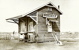
Cook is a railway station and crossing loop located in the Australian state of South Australia on the Trans-Australian Railway. It is 824 kilometres by rail from Port Augusta, 863 kilometres by rail from Kalgoorlie, and about 100 kilometres (62 mi) north of the Eyre Highway via an unsealed road. It is on the longest stretch of straight railway in the world, at 478 kilometres (297 mi), which extends from Ooldea, South Australia to beyond Loongana, Western Australia.
Rail transport in Australia is a component of the Australian transport system. It is to a large extent state-based, as each state largely has its own operations, with the interstate network being developed ever since Australia's federation in 1901. As of 2022, the Australian rail network consists of a total of 32,929 kilometres (20,461 mi) of track built to three major track gauges: 18,007 kilometres (11,189 mi) of standard gauge, 2,685 kilometres (1,668 mi) of broad gauge, and 11,914 kilometres (7,403 mi) of narrow gauge lines. Additionally, about 1,400 kilometres (870 mi) of 610 mm / 2 ft gauge lines support the sugar-cane industry. 3,488 kilometres (2,167 mi), around 11 per cent of the Australian heavy railways network route-kilometres are electrified.
Australians generally assumed in the 1850s that railways would be built by the private sector. Private companies built railways in the then colonies of Victoria, opened in 1854, and New South Wales, where the company was taken over by the government before completion in 1855, due to bankruptcy. South Australia's railways were government owned from the beginning, including a horse-drawn line opened in 1854 and a steam-powered line opened in 1856. In Victoria, the private railways were soon found not to be financially viable, and existing rail networks and their expansion were taken over by the colony. Government ownership also enabled railways to be built to promote development, even if not apparently viable in strictly financial terms. The railway systems spread from the colonial capitals, except for a few lines that hauled commodities to a rural port.
The first railway in colonial South Australia was a line from the port of Goolwa on the River Murray to an ocean harbour at Port Elliot, which first operated in December 1853, before its completion in May 1854.
The Australian Rail Track Corporation (ARTC) is an Australian Government-owned statutory corporation.
The Eastern Goldfields Railway was built in the 1890s by the Western Australian Government Railways to connect Perth with the Eastern Goldfields at Coolgardie and Kalgoorlie.
The Westland was the name given in 1938 to the overnight train operated by the Western Australian Government Railways (WAGR) with sitting and sleeping cars between Perth and Kalgoorlie, where it connected with the Trans-Australian service to Adelaide.
The Commonwealth Railways were established in 1917 by the Government of Australia with the Commonwealth Railways Act to administer the Trans-Australia and Port Augusta to Darwin railways. In 1975, all assets were acquired by the Australian National Railways Commission, branded as Australian National Railways and subsequently Australian National, trademarked as AN.
Salisbury railway station is a railway station and bus interchange in the northern Adelaide suburb of Salisbury. It is on the Gawler line, 20.2 kilometres (12.6 mi) from Adelaide station. Adjoining it is a large park & ride carpark, making it one of the busiest stations on the Adelaide suburban rail system.
Kalgoorlie railway station is the easternmost attended station in Western Australia, located at the eastern terminus of the Eastern Goldfields Railway. It serves the city of Kalgoorlie. Beyond Kalgoorlie, the line continues east as the Trans-Australian Railway.
The Sydney–Perth rail corridor is a 1435 mmstandard gauge railway route that runs for 4352 kilometres (2704 mi) across Australia from Sydney, New South Wales, to Perth, Western Australia. Most of the route is under the control of the Australian Rail Track Corporation.
The Crystal Brook–Broken Hill railway line is a 371 kilometre line running from Crystal Brook to Broken Hill on the Australian Rail Track Corporation network.
The Adelaide–Port Augusta railway line is the main route for northbound rail traffic out of Adelaide, South Australia. The line, 315 kilometres long, is part of the Adelaide–Darwin rail corridor and the Sydney–Perth rail corridor.
When the Trans-Australian Railway was completed in 1917 from Kalgoorlie to Port Augusta, about 50 settlements of various sizes were established along the line, from which maintenance workers kept the track in operational condition. They and their families led an isolated life, although they were supplied with provisions by a weekly special train, which also provided banking and postal facilities. Passenger trains were hauled by steam locomotives, which needed to take on water at various stopping places. The 1930s to 1940s services required regular stops on the traverse.
The Trans-Australian was an Australian passenger train operated by the Commonwealth Railways initially between Port Augusta and Kalgoorlie on the Trans-Australian Railway line, and later extended west to Perth, and east to Port Pirie and Adelaide.
The Commonwealth Railways G class was a class of twenty-six 4-6-0 tender locomotives of the Commonwealth Railways, Australia. The class operated between Port Augusta and Kalgoorlie on the 1435 mm Trans-Australian Railway.
Port Augusta railway station is a rail station located on the Adelaide-Port Augusta railway line in Port Augusta, South Australia.
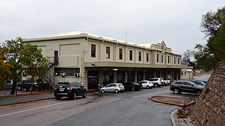
Port Pirie railway station (Mary Elie Street) was the fifth of six railway stations for passengers that operated at various times from 1876 to serve the small maritime town (later city) of Port Pirie, 216 kilometres (134 miles) by rail north of Adelaide, South Australia. As with several of Port Pirie's other stations before it, the station was built to accommodate a change of track gauge on railway lines leading into the town.
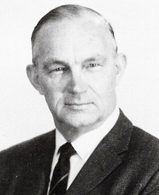
Ronald John Fitch was an Australian railway executive and railway engineer. The majority of his working career was with the Western Australian Government Railways, Commonwealth Railways and the South Australian Railways, where he served as the Railway Commissioner from 1965 until 1973.
References
↑ A history of Australian road and rail, Adelaide: Department for Transport and Infrastructure, South Australia, 2012, p.2
↑ Anchen, Nick (2017). Iron Roads in the Outback: The Legendary Commonwealth Railways. Ferntree Gully, Vic: Sierra Publishing. ISBN9780992538828.:147
↑ "The Last Link". The West Australian. Vol.XXXIII, no.4, 850. Western Australia. 18 October 1917. p.4. Retrieved 17 October 2017– via National Library of Australia.
↑ Fitch, Ronald J. (2006). Australian Railwayman: from cadet engineer to railways commissioner. Dural, New South Wales: Rosenberg Publishing Pty Ltd. ISBN1877058483.
↑ Vincent, Graham (2013). "South Australia's mixed gauge muddle"(PDF). National Railway Museum (South Australia). National Railway Museum. Archived from the original(PDF) on 28 February 2016. Retrieved 29 July 2021.
↑ Taylor, Paige (17 October 2017). "Celebrating rail's united nation, 100 years on". The Australian.subscription: the source is only accessible via a paid subscription ("paywall")
↑ Burke, David (1991). Road through the wilderness: the story of the Transcontinental Railway, the first great work of Australia's Federation. Kensington NSM: New South Wales University Press. ISBN0868401404.
↑ Oberg, Leon (1984). Locomotives of Australia 1850's – 1980's. Frenchs Forest: Reed Books. pp.122, 164. ISBN0-730100-05-7.
↑ "EXTENSIVE Washaways". Western Argus. Vol.43, no.2438. Western Australia. 9 March 1937. p.4. Retrieved 5 February 2022– via National Library of Australia.
↑ "TRAINS DELAYED". The Northern Herald. Vol.XLVIII, no.522. Queensland, Australia. 5 March 1930. p.22. Retrieved 5 February 2022– via National Library of Australia.
Burke, David, (1991) Road Through the Wilderness: The Story of the Transcontinental Railway, the First Great Work of Australia's Federation. Kensington, N.S.W.: New South Wales University Press. ISBN0-86840-140-4
Cree, Patricia (2012). The Trans-Australian Railway: Bringing the nation together. Canberra Airport, ACT: Australasian Railway Association. ISBN9780646584249.
Luke, Monte (1997). Riders of the Steel Highways: The History of Australia's Commonwealth Railways 1912-1975. Port Augusta, SA: VM & BM Luke. ISBN0646346520.
Spear, R. Clarke (1917) The Golden West: Trans-Australian Christmas number Perth, Western Australia "The Golden West, Vol. 13, December 1917."
This page is based on this Wikipedia article Text is available under the CC BY-SA 4.0 license; additional terms may apply. Images, videos and audio are available under their respective licenses.


