Port Pirie railway station (Mary Elie Street)

Last updated

Port Pirie railway station (Mary Elie Street)
(1967–1989)
Commonwealth Railways Budd car CB2 and 4-wheel van at Mary Elie Street station platform, Port Pirie, ca 1969.jpg
Budd railcar CB2 and a luggage van waiting on the Commonwealth Railways (standard gauge) side of the Mary Elie Street platform, about half-way along its 700-metre (770-yard) length, about 1969. Broad-gauge South Australian Railways trains arrive on the other side.
General information
LocationEntrance 3 Mary Elie Street, Port Pirie, South Australia; parallel to Wandearah Road
Coordinates 33°11′03″S138°00′43″E / 33.1843°S 138.0119°E / -33.1843; 138.0119
Owned by South Australian Railways and Commonwealth Railways 1967–1975
Australian National Railways Commission 1975–1989
Line(s) Adelaide to Port Pirie
GaugeStandard – 1435 mm (4 ft 812 in)
Broad – 1600 mm (5 ft 3 in)
StructureTwo concrete brick buildings: booking office and refreshment room
Platform configurationOne raised island platform: broad gauge on western side (South Australian Railways), standard gauge on eastern side (Commonwealth Railways)
Platform length
700 metres (770 yards)
StoppingAll through passenger trains on standard-gauge Sydney–Perth rail corridor
Passenger trains on broad-gauge line to Adelaide
Opened12 November 1967
Closed1989
Immediate predecessor stations Ellen Street, 1885–1967
Solomontown, 1911–1970
Port Pirie Junction, 1937–1967
Successor
station
Coonamia provisional stopping place, 1989–2010s

Port Pirie railway station (Mary Elie Street) was the fifth of six stations that operated at various times from 1876 to serve the small maritime town (later city) of Port Pirie, 216 kilometres (134 miles) by rail north of Adelaide, South Australia. As with several of Port Pirie's other stations before it, the station was built to accommodate a change of track gauge on railway lines leading into the town.

Contents

Layout of the station and sidings Layout of Mary Elie Street station and sidings, Port Pirie, South Australia.tif
Layout of the station and sidings
Links to the articles about stations in Port Pirie
 StationDurationGauge
1 Port Pirie (at what became known as Port Pirie South)1876 to after 1911ng 
2 Ellen Street 1902–1967ng bg*
3Solomontown1911–1967ng
4 Port Pirie Junction – also signposted as, and known colloquially as, Solomontown1937–1967ngbgsg
5Mary Elie Street (this article)1967–1989bgsg
6 Coonamia stopping place 1st, 1929 to after 1937
2nd, 1989–2010s
sg
* In 1937, one of the two narrow-gauge tracks along Ellen Street was made dual-gauge by the addition of broad-gauge rails.

Gauges are shown in these colours: narrow, broad and standard.

Port Pirie's six stations and the "multigauge muddle"
At various times during a period of close to 140 years, Port Pirie had six railway stations. During the 45-year period 1937–1982, the city became well known as one of the few locations in the world having three railway gauges. [note 1] This situation was a result of South Australia's slow transition from lightly constructed narrow gauge to heavy-rail broad gauge (which predominated in the state at the time), then to standard gauge when lines between the mainland state capitals were at last unified. As a consequence, all Port Pirie stations that succeeded the inaugural station of 1876 were either built to accommodate a change of gauge or were affected by one. The timeline, reasons for change, and gauges involved are shown in the following graphic.

Timeline of Port Pirie's six railway stations
Timeline of Port Pirie's six railway stations.jpg
Mary Elie Street's passenger facilities were dwarfed by the sidings (standard gauge blue, broad gauge brown) installed in readiness for the conversion of the South Australian sector of the Sydney-Perth rail corridor to 1435 mm (
4 ft 8+1/2 in) standard gauge. (Click to enlarge.) Track layout Port Pirie main yard and Mary Elie Street station 1970-1989.tif
Mary Elie Street's passenger facilities were dwarfed by the sidings (standard gauge blue, broad gauge brown) installed in readiness for the conversion of the South Australian sector of the Sydney–Perth rail corridor to 1435 mm (4 ft 8+12 in) standard gauge. (Click to enlarge.)

Need for a new station

In 1966, planning commenced for the long-overdue conversion to 1435 mm (4 ft 8+12 in) standard gauge of the South Australian Railways 1067 mm (3 ft 6 in) narrow gauge line from Port Pirie to the New South Wales border. This project was to culminate in 1970, when for the first time trains were able to travel the entire Sydney–Perth rail corridor without a change of gauge.

Map including the Mary Elie railway station (5) and the evolution of Port Pirie's three railway gauges (click to enlarge) Port Pirie's six railway stations from 1876 to the 2010s.png
Map including the Mary Elie railway station (5) and the evolution of Port Pirie's three railway gauges (click to enlarge)

At Port Pirie, new standard-gauge sidings and other facilities would be needed to handle the increased freight and passenger traffic enabled by the upgraded line. At that time the city had three passenger stations:

Implementation

Although space was limited in Port Pirie's rail yards, standard-gauge and broad-gauge track would replace the narrow-gauge sidings (in new configurations) at Port Pirie South yard. Passengers, parcels and mail would transfer across a new island platform paralleling Wandearah Road; the station entrance would front Mary Elie Street. As before, broad-gauge trains came from Adelaide, to the south, and standard-gauge trains from Port Augusta, to the north; the new element was standard-gauge trains from Broken Hill, to the east. [2] :1‑639

The configuration of tracks and platform was not easily devised – the South Australian Railways insisted that all freight and passenger traffic from the rail corridor would enter the Port Pirie yard and station. [3] Since there was no room for track to continue on at the northern end, the station would have to be a stub terminal, and without the capacity that would allow passengers to join or leave at the middle or either end of the train, a platform capable of holding an entire passenger train was necessary. The Indian Pacific, on its cross-continent journey due to commence in January 1970, would be much longer than the trains operating before then, namely the Trans-Australian to Western Australia, other standard-gauge services to Whyalla and Woomera, and the East–west Express and other trains to Adelaide. Therefore, the platform would need to be 700 metres (770 yards) long – the longest in Australia. [4]

The new station, from which trains started to run on 12 November 1967, [5] was well received by the town populace; Port Pirie Town Council had been advocating a terminal station there for more than 25 years. [6] :3‑246 [1]

Facilities

Facilities constructed at the station included a waiting room, a refreshment room, a resthouse for train crew, a locomotive stabling depot, diesel fuelling, passenger car water supply, and a turntable. [7] As had occurred at Port Pirie Junction station, a run-around loop on each side permitted locomotives to be detached and turned, and a shunting locomotive took the carriages away to be placed in the sequence needed for the return journey. [note 2] The Indian Pacific, which first arrived in Port Pirie on 24 February 1970, [8] was the exception: since Port Pirie was only a pause in its journey, its carriages did not need to be rearranged. However, the entire train needed to be pushed back for 3.6 kilometres (2.2 miles) [9] to return to the mainline and continue on its way – a time-wasting procedure. Much longer operating delays occurred with freight traffic, not only because of the dead-end configuration of the tracks but also because broad-gauge and standard-gauge bogies had to be exchanged on all freight cars that travelled between the South Australian Railways and Commonwealth Railways. A 1971 report stated: "It is expected that in the near future the Australian National Railways Commission will construct a by-pass line around the Port Pirie yard and station to facilitate the fast through movement of freight trains between Sydney and Perth." [3]

In the event, the by-pass line was not laid around the Port Pirie's rail yards and station but on the mainline, where tracks forked out from the yards' exit: north to Port Augusta and south to Crystal Brook, the latter standardised in 1970. The "missing link" between them was completed in 1978 by 600 metres (660 yards) of new track to form the "Coonamia triangle", which not only enabled straight-through traffic but provided a useful means of turning locomotives and trains. [4] [note 3] By then, the Australian National Railways Commission had acquired the South Australian Railways and Commonwealth Railways, so locomotives did not have to be changed at Mary Elie Street when going to and from what had previously been separate systems. [2] :1‑639 The Indian Pacific , however, did not bypass the station until 1986. [3]

Closure

Mary Elie Street station closed on 5 February 1989. [2] :1‑659 It was still considered necessary to provide a facility for Port Pirie passengers of The Ghan , Indian Pacific , and (until June 1991, when it ceased) the Trans-Australian , [2] :1‑659 [10] so a tiny "provisional" stop was simultaneously re-established at Coonamia (see map, station 6), allowing trains to pick up and drop off Port Pirie passengers without having to go through the reversing procedure.

Nine months later, the federal House of Representatives Standing Committee on Transport, Communications and Infrastructure recommended that the Indian Pacific and Trans-Australian, which still ran over three different rail authorities' [note 4] tracks, be booked, staffed and controlled by Australian National and be upgraded, refurbished and marketed as luxury train journeys. [3] Further, "Intra-state passengers should only be carried on a stand-by basis, and should rely on alternatives for their primary transport requirements". [11] :42 Australian National acted quickly to discontinue South Australian non-metropolitan intrastate train services, which it achieved in December 1989. [note 5] Since it served interstate trains, Coonamia remained in use until the 2010s, although climbing down over the ballast shoulder and down to ground level was a difficult, undignified travel experience for the few people who persisted in travelling on a long-distance train within their state.

In 1990, tracks to, and at, the Mary Elie Street platform were lifted. [2] :1‑675 Redevelopment of the northern (ticket office) end as the Port Pirie's tourist information centre, arts centre and public library was completed in 2009. Until 2012, a former Commonwealth Railways GM class locomotive and three 1950s-era passenger cars [12] were stabled at the platform as a public display; one car was a restaurant providing on-the-job training for young people in the hospitality industry with the support of Port Pirie Regional Council and The Foundation for Young Australians. [13]

As of 2021, the platform, its canopy and the block formerly used as a waiting room remained. A miniature railway operated in the garden surrounds. The forecourt served as a bus station. [14]

Post-closure

Following the station's closure, three types of railway operations continued at Port Pirie: [15]


Preceding stations: Ellen Street, Port Pirie Junction, and Solomontown.

Concurrent station: none.

Subsequent station: Coonamia provisional stopping place.

Notes

  1. The gauges were 1067 mm (3 ft 6 in), 1435 mm (4 ft 8+12 in), and 1600 mm (5 ft 3 in).
  2. Sequence of vehicles: almost invariably, trains from Adelaide to Port Pirie comprised two freight cars immediately behind the locomotive, three steel passenger cars – often two 700 or 600 (second-class) cars and one 780 or 500 (first-class) cars – followed by a 12-wheeled brakevan and (typically) three boxcars with passenger-car bogies. Sometimes, urgent interstate loading was also added behind the locomotive, such as up to three double-deck automotive carriers. When a cafeteria car was present, it was placed between the first-class and second-class cars. Steam locomotives (ending in 1977) were 600, 620, and 520 classes. Diesel locomotives were 900 and, less often, 930 class. In latter years especially, Bluebird railcars provided the service. [6] :3‑244
  3. Inwards traffic continued to be lead-zinc-silver ore for the Port Pirie smelter; outwards traffic was mainly bunker fuel for the power station at Broken Hill and sulphuric acid from the smelter.
  4. Western Australian government, New South Wales government, and Australian National.
  5. Rail passenger services to Broken Hill and Whyalla were an exception, although they too ceased operating on 2 January 1991. The last Budd railcar to Whyalla ran on 31 December 1990. [2] :1‑667

Related Research Articles

<i>Indian Pacific</i> Passenger train service in Australia

The Indian Pacific is a weekly experiential tourism passenger train service that runs in Australia's east–west rail corridor between Sydney, on the shore of the Pacific Ocean, and Perth, on the shore of the Indian Ocean – thus, like its counterpart in the north–south corridor, The Ghan, one of the few truly transcontinental trains in the world. It first ran in 1970 after the completion of gauge conversion projects in South Australia and Western Australia, enabling for the first time a cross-continental rail journey that did not have a break of gauge.

In railway engineering, "gauge" is the transverse distance between the inner surfaces of the heads of two rails, which for the vast majority of railway lines is the number of rails in place. However, it is sometimes necessary for track to carry railway vehicles with wheels matched to two different gauges. Such track is described as dual gauge – achieved either by addition of a third rail, if it will fit, or by two additional rails. Dual-gauge tracks are more expensive to configure with signals and sidings, and to maintain, than two separate single-gauge tracks. It is therefore usual to build dual-gauge or other multi-gauge tracks only when necessitated by lack of space or when tracks of two different gauges meet in marshalling yards or passenger stations. Dual-gauge tracks are by far the most common configuration, but triple-gauge tracks have been built in some situations.

<span class="mw-page-title-main">Adelaide railway station</span> Railway station in Adelaide, South Australia

Adelaide railway station is the central terminus of the Adelaide Metro railway system. All lines approach the station from the west, and it is a terminal station with no through lines, with most of the traffic on the metropolitan network either departing or terminating here. It has nine below-ground platforms, all using broad gauge track. The station is located on the north side of North Terrace, west of Parliament House.

<span class="mw-page-title-main">Goodwood railway station</span> Railway station in Adelaide, South Australia

Goodwood railway station is the junction station for the Belair, Seaford and Flinders lines. The Belair line diverges south-east towards Millswood, while the Seaford and Flinders lines diverge south-west towards Clarence Park. The Glenelg tram line crosses over the railway lines at the south end of Goodwood station. The station services the Adelaide inner-southern suburb of Goodwood, and is 5.0 km from Adelaide station.

Australians generally assumed in the 1850s that railways would be built by the private sector. Private companies built railways in the then colonies of Victoria, opened in 1854, and New South Wales, where the company was taken over by the government before completion in 1855, due to bankruptcy. South Australia's railways were government owned from the beginning, including a horse-drawn line opened in 1854 and a steam-powered line opened in 1856. In Victoria, the private railways were soon found not to be financially viable, and existing rail networks and their expansion were taken over by the colony. Government ownership also enabled railways to be built to promote development, even if not apparently viable in strictly financial terms. The railway systems spread from the colonial capitals, except for a few lines that hauled commodities to a rural port.

<span class="mw-page-title-main">Rail transport in South Australia</span> Rail transport in South Australia

The first railway in colonial South Australia was a line from the port of Goolwa on the River Murray to an ocean harbour at Port Elliot, which first operated in December 1853, before its completion in May 1854.

<span class="mw-page-title-main">Trans-Australian Railway</span> Railway between Port Augusta, South Australia and Kalgoorlie, Western Australia

The Trans-Australian Railway, opened in 1917, runs from Port Augusta in South Australia to Kalgoorlie in Western Australia, crossing the Nullarbor Plain in the process. As the only rail freight corridor between Western Australia and the eastern states, the line is economically and strategically important. The railway includes the world's longest section of completely straight track.

<span class="mw-page-title-main">Dry Creek–Port Adelaide railway line</span> Railway line in Adelaide, South Australia

The Dry Creek–Port Adelaide railway line is an eight-kilometre east–west freight railway line running through Adelaide's north-western suburbs. The line is managed by the Australian Rail Track Corporation (ARTC) and is an important link between Port Adelaide, Pelican Point and the main interstate rail routes which link Adelaide with Melbourne, Perth, Darwin and Sydney. Prior to 1988, a limited local passenger service operated, stopping at five intermediate stations along the line. Since May 1988, the line has been freight-only.

<span class="mw-page-title-main">South Australian Railways</span> Government department that ran South Australias railways from 1854 to 1978

South Australian Railways (SAR) was the statutory corporation through which the Government of South Australia built and operated railways in South Australia from 1854 until March 1978, when its non-urban railways were incorporated into Australian National, and its Adelaide urban lines were transferred to the State Transport Authority.

<span class="mw-page-title-main">Salisbury railway station, Adelaide</span> Railway station in Adelaide, South Australia

Salisbury railway station is a railway station and bus interchange in the northern Adelaide suburb of Salisbury. It is on the Gawler line, 20.2 kilometres (12.6 mi) from Adelaide station. Adjoining it is a large park & ride carpark, making it one of the busiest stations on the Adelaide suburban rail system.

<span class="mw-page-title-main">South Australian Railways 620 class</span>

The South Australian Railways 620 class was a class of 4-6-2 steam locomotives operated by the South Australian Railways.

<span class="mw-page-title-main">Freight railways in Melbourne</span>

The rail network of Melbourne, Australia, has a significant number of railway lines and yards serving freight traffic. Rail transport in Victoria is heavily focused on Melbourne, and, as a consequence, much of the state's rail freight passes through the metropolitan network.

The South Kensington–West Footscray line is a railway line in the inner western suburbs of Melbourne, Australia. Linking South Kensington station on the Werribee line and associated freight terminals to Tottenham Yard and other freight lines, it is a primarily freight only line with no overhead wires, passenger stations or platforms. The most visible part of the line is where it dives under Footscray station and into a tunnel under nearby Bunbury Street.

The Adelaide–Port Augusta railway line is the main route for northbound rail traffic out of Adelaide, South Australia. The line, 315 kilometres long, is part of the Adelaide–Darwin rail corridor and the Sydney–Perth rail corridor.

This article lists significant fatal, injury-only, and other accidents involving railway rolling stock, including crashes, fires and other incidents in the Australian state of South Australia. The first known incident in this list occurred in 1873 in Smithfield, South Australia.

<span class="mw-page-title-main">Coonamia railway station</span> Railway station in South Australia

Coonamia railway station was a "provisional stopping place" for passenger trains in the rural locality of the same name, 5.0 km (3.1 mi) by rail south-east of the centre of the city of Port Pirie, South Australia. It was operational for two separate periods:

<span class="mw-page-title-main">Port Augusta railway station</span> Railway station in South Australia

Port Augusta railway station is a rail station located on the Adelaide-Port Augusta railway line in Port Augusta, South Australia.

<span class="mw-page-title-main">Port Pirie railway station (Ellen Street)</span> Former railway station in South Australia, Australia

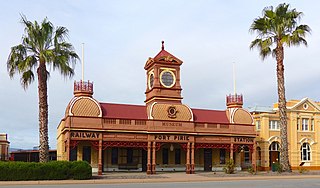
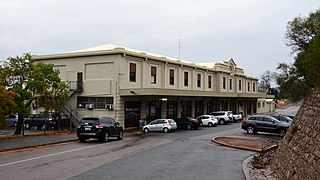
Ellen Street railway station was the second of six stations that operated successively between 1875 and the early 2010s to serve the rural maritime town of Port Pirie, 216 km (134 mi) by rail north of Adelaide, South Australia. Soon after construction of the line towards Gladstone began in 1875, an impromptu passenger service commenced. The inaugural station, Port Pirie South, was 800 metres from the centre of the town. Since two tracks had already been laid down the middle of Ellen Street to the wharves, a small corrugated iron shed was erected as a ticket and parcels office. The street-side location was unusual for the South Australian Railways. In 1902, when passenger traffic had increased greatly, a stone building was erected in a striking Victorian Pavilion style. After the tracks were removed in 1967 and the station closed, the building's design assured its retention as a museum of the National Trust of South Australia.

<span class="mw-page-title-main">Solomontown railway station</span> Railway station in South Australia

Solomontown railway station was one of a total of six stations that operated at various times between 1876 and the early 2010s to serve the rural maritime town of Port Pirie, 216 km (134 mi) by rail north of Adelaide, South Australia. It was opened in 1911 as the town's third narrow-gauge station. It was closed in 1967, when narrow-gauge passenger services ceased.

References

  1. 1 2 "Pirie terminus: Mary Elie Street site: Council wants no trains in Ellen Street". The Recorder . No. 12, 371. Port Pirie. 31 March 1943. p. 1. Retrieved 8 September 2021.
  2. 1 2 3 4 5 6 Ramsey, John (2008). "History of the Australian National Railways Commission, part 1: 1978–1990". Proceedings of the 2008 convention. Modelling the Railways of South Australia. Adelaide.
  3. 1 2 3 4 Webb, G.R. (1976). "The planning and management of rail standardization projects in Australia" (PDF). Australasian Transport Research Forum. ARTF Incorporated. p. 48. Retrieved 8 September 2021.
  4. 1 2 Vincent, Graham (2019). "Coonamia–Weeroona (diagram AR080 – page 26)" (PDF). SA Track and Signal. G.F. Vincent. Retrieved 24 January 2020.
  5. South Australian Railways (1967). Weekly Notice 44/67. Cited in Drymalik, Chris (2021). "Route information Adelaide to Port Pirie". Chris's Commonwealth railways information (ComRails). Chris Drymalik. Retrieved 12 September 2021.
  6. 1 2 Barrington, Rodney (2006). "Port Pirie passenger trains". Proceedings of the 2006 convention. Modelling the Railways of South Australia. Adelaide.
  7. Australian National Railways (1979). Working Timetable 1 July. Cited in Drymalik, Chris (2021). "Route information Port Pirie to Broken Hill". Chris's Commonwealth railways information (ComRails). Chris Drymalik. Retrieved 12 September 2021.
  8. "Indian Pacific train turns 40". WA Today. theage.com.au. 23 February 2010. Retrieved 25 February 2010.
  9. Google Earth: "Port Pirie SA".
  10. "Western Report". Australian Railway Historical Society Bulletin . Redfern: Australian Railway Historical Society. September 1986. p. 281.
  11. House of Representatives Standing Committee on Transport, Communications and Infrastructure (November 1989). Rail: five systems – one solution: the efficiency of Australian National's east–west operations (PDF). Canberra: Australian Government Publishing Service.
  12. Wegmann cars.
  13. Weston Langford Railway Photography.
  14. "Tourism & Arts Centre". Port Pirie Regional Council. 2021. Retrieved 12 September 2021.
  15. Vincent, Graham (2022). "Port Pirie environs" (PDF). SA Track and Signal. G.F. Vincent. Retrieved 21 August 2023.