Yowaka River bridge, Greigs Flat

Last updated

Yowaka River Bridge
1486 - Yowaka Bridge near Eden - SHR Plan No 2831 (5051390b100).jpg
Heritage boundaries
Coordinates 36°57′33″S149°52′18″E / 36.9593°S 149.8718°E / -36.9593; 149.8718 Coordinates: 36°57′33″S149°52′18″E / 36.9593°S 149.8718°E / -36.9593; 149.8718
Carries Princes Highway AUS Alphanumeric Route A1.svg
Crosses Yowaka River
Locale Greigs Flat, New South Wales, Australia
Owner Transport for NSW
Characteristics
DesignContinuous girder bridge
Material Reinforced concrete
Total length65.22 metres (214.0 ft)
Longest span18.28 metres (60.0 ft)
No. of spans4
History
Opened1936
Rebuilt1994
ReplacesSaltwater Bridge
Official nameYowaka Bridge near Eden; Yowaka River bridge, Greigs Flat; Greigs Flat Bridge over Yowaka River
TypeState heritage (built)
Designated20 June 2000
Reference no.1486
TypeRoad Bridge
CategoryTransport - Land
Location
Yowaka River bridge, Greigs Flat

The Yowaka River bridge is a heritage-listed road bridge that carries the Princes Highway across the Yowaka River at Greigs Flat, New South Wales, Australia. It was built in 1936. The bridge is also known as the Yowaka Bridge near Eden. The bridge is owned by Transport for NSW. It was added to the New South Wales State Heritage Register on 20 June 2000. [1]

Contents

History

The current bridge replaced an earlier timber bridge named Saltwater Bridge. (The Yowaka River was previously known as Saltwater River). Early road construction south of Nowra was not as continuous or well planned as in the Illawarra. The majority of roads were rough bridle tracks and were privately funded. An official line was surveyed in 1859 from Merimbula to Bega. In 1864, the government extended the road from Moruya to Bega. River crossings were problematic and it was not until the 1870s that improvements on river crossings were undertaken in the form of punts or bridges. It is likely that the first Saltwater River bridge was constructed in the 1870s or 1880s. Construction of the current bridge was undertaken as part of improvements to the Princes Highway in the 1930s. It was widened in 1994 to cater for modern traffic demands by overlaying the original deck with reinforced concrete and cantilevering it to the increased width. The longitudinal beams were post-tensioned at the end spans to augment the load carrying capacity. [1]

Description

The four-span, concrete girder bridge, simply supported continuous-over-pier bridge on a 26 degree skew, is supported on three internal piers and abutments on both ends. The north end is anchored on to the abutment and the remaining supports have rocker bearings to allow movement to the bridge deck. The deck was widened in 1994. Each of the three piers consists of two octagonal columns about 2.3 metres (7 ft 7 in) from the top of the pile cap. A concrete diaphragm connects the two columns at mid-height and is approximately 1.8 metres (5 ft 11 in) high. The thickness of the diaphragms is approximately 0.32 metres (1 ft 1 in). Two of the piers are supported on caissons while the third is supported on driven piles. The overall length of the bridge is 65.22 metres (214.0 ft) with spans of 14.42 metres (47.3 ft), 18.28 metres (60.0 ft), and 14.32 metres (47.0 ft) respectively. The deck is integral with two downstand beams running the full length of the bridge. The beams are curved, with haunches at each support point. Traverse cross beams, integral with the deck span are located between the longitudinal beams at regular intervals. The reinforcement in the original concrete consists of round bars. The concrete finish to the original structure is shutter or board finished and is aesthetically laid in the soffit area and horizontal on the abutments and piers. [1]

The bridge was reported to be in good condition as at 15 June 2005, but had been damaged by fire as a result of a fuel tanker accident in June 1999. [1]

Heritage listing

The bridge is of high state significance. It demonstrates how bridge designs evolved to address the structural capabilities or reinforced concrete compared to the traditional materials of masonry, timber and steel. It is a fine example of a continuous girder reinforced concrete bridge, a type constructed in a limited period between 1934 and World War II. It is part of the upgrade of the Princes Highway which commenced in 1924. It includes aesthetic qualities such as shuttering / formwork patterning, curved lines and a light graceful form, which addresses the construction process and structural characteristics unique to reinforced concrete. It is one of four continuous two girder reinforced concrete bridges in NSW and the only example with concrete bearings. [1]

Yowaka Bridge near Eden was listed on the New South Wales State Heritage Register on 20 June 2000 having satisfied the following criteria. [1]

The place is important in demonstrating the course, or pattern, of cultural or natural history in New South Wales.

Yowaka Bridge demonstrates the adoption or reinforced concrete as a relatively new material and the development of reinforced concrete bridge designs, which emerged during the late nineteenth and early twentieth centuries. Continuous girder bridges were one of the five reinforced concrete bridge types developed following the formation of the Main Roads Board in 1924. The bridge forms part of the Princes Highway and was part of the overall improvement works on the highway after the formation of the Main Roads Board. [1]

The place is important in demonstrating aesthetic characteristics and/or a high degree of creative or technical achievement in New South Wales.

The surface form and texture created by the formwork and shutter design on the soffit, abutments and piers demonstrates that the architectural attributes of the bridge were part of the overall design and were not purely utilitarian. The level of detailing present on the soffit indicates that the architectural detailing was as important as the structural design. The subtle arches, level springings and haunches along the main beam / girder complement the structural characteristics and potential of reinforced concrete, which allowed a lighter and more graceful bridge design. [1]

The place possesses uncommon, rare or endangered aspects of the cultural or natural history of New South Wales.

In 1999, one of four continuous two girder reinforced concrete bridges in NSW and the only example with concrete bearings. (Others are Kellys Gully Creek near Warialda Rail; Warialda Creek; Croobyar Creek) [1]

The place is important in demonstrating the principal characteristics of a class of cultural or natural places/environments in New South Wales.

Yowaka Bridge is a fine example of a continuous reinforced concrete girder bridge. It contains all the attributes of a continuous reinforced concrete girder bridge as well as the fine architectural detailing. It is one of only ten such bridges in NSW. [1]

See also

Related Research Articles

<span class="mw-page-title-main">Gladesville Bridge</span> Bridge in Sydney, Australia

Gladesville Bridge is a heritage-listed concrete arch road bridge that carries Victoria Road over the Parramatta River, linking the Sydney suburbs of Huntleys Point and Drummoyne, in the local government areas of Canada Bay and Hunter's Hill, in New South Wales, Australia. Despite its name, the bridge is not located in Gladesville.

<span class="mw-page-title-main">Hampden Bridge, Kangaroo Valley</span> Bridge in New South Wales, Australia

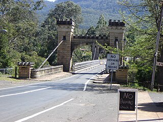
Hampden Bridge is a heritage-listed single-span suspension bridge that carries Moss Vale Road (B73) across the Kangaroo River, in Kangaroo Valley, in the City of Shoalhaven local government area of New South Wales, Australia. The bridge was designed by Ernest de Burgh and built by Loveridge and Hudson. The property is owned by Transport for NSW. It was added to the New South Wales State Heritage Register on 2 August 2019.

<span class="mw-page-title-main">Iron Cove Bridge</span> Bridge in New South Wales, Australia

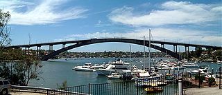
The Iron Cove Bridge is a heritage-listed road bridge that carries Victoria Road (A40) across Iron Cove, linking the Sydney suburbs of Drummoyne to Rozelle in the City of Canada Bay local government area of New South Wales, Australia.

<span class="mw-page-title-main">Fig Tree Bridge</span> Bridge in New South Wales, Australia

The Fig Tree Bridge is a road bridge that carries Burns Bay Road across the Lane Cove River, and connects the suburbs of Hunters Hill in the south and Linley Point in the north, located approximately seven kilometres northwest of the central business district of Sydney in New South Wales, Australia. The concrete girder bridge carries motor vehicles, and a grade-separated footpath and cycleway.

<span class="mw-page-title-main">Hawkesbury River railway bridge</span> Railway bridge in New South Wales, Australia

The Hawkesbury River railway bridge is a heritage-listed railway bridge in New South Wales, Australia that carries the Main North railway line across the Hawkesbury River. It is located just north of the town of Brooklyn on the northern outskirts of Sydney. The railway bridge was to be the last link in a railway network that linked the state capitals Adelaide, Melbourne, Sydney and Brisbane and was a major engineering feat at the time. The original railway bridge was built in 1889 and replaced by the current bridge in 1946. The 1946 bridge was added to the New South Wales State Heritage Register on 2 April 1999.

<span class="mw-page-title-main">Victoria Bridge (Penrith)</span> Heritage-listed bridge across the Nepean River in Sydney, Australia

The Victoria Bridge (Penrith), also known as the Victoria Bridge over Nepean River and officially known as The Nepean Bridge, is a heritage-listed former railway bridge and now wrought iron box plate girder road bridge across the Nepean River on the Great Western Highway in the western Sydney suburb of Penrith in the City of Penrith local government area of New South Wales, Australia. The bridge was designed by John Whitton, the Engineer–in–Chief of New South Wales Government Railways, and built from 1862 to 1867 by William Piper, Peto Brassey and Betts (superstructure), William Watkins (piers). It is also known as Victoria Bridge, The Nepean Bridge and RTA Bridge No. 333. It was added to the New South Wales State Heritage Register on 27 May 2016.

<span class="mw-page-title-main">Fullers Bridge</span> Road bridge in suburban Sydney, Australia

Fullers Bridge, officially called the Fullers Creek Bridge, is a road bridge that carries Delhi Road to Millwood Avenue across the Lane Cove River, in Chatswood West, Sydney, New South Wales, Australia. The concrete beam bridge is located 9 kilometres (5.6 mi) northwest of the Sydney central business district and connects Chatswood to North Ryde as part of the A38.

<span class="mw-page-title-main">Peats Ferry Bridge</span> Bridge in New South Wales, Australia

The Peats Ferry Bridge is a steel truss bridge that carries the Pacific Highway (B83) across the Hawkesbury River, between Kangaroo Point and Mooney Mooney Point, located 40 kilometres (25 mi) north of Sydney in New South Wales, Australia. The bridge carries the Hornsby to Kariong section of highway, while the adjacent Brooklyn Bridge carries the Pacific Motorway (M1).

<span class="mw-page-title-main">Taemas Bridge</span> Bridge in New South Wales, Australia

The Taemas Bridge is a two-lane road bridge that carries the Wee Jasper Road across the Murrumbidgee River, at the settlement of Taemas, near Wee Jasper in the Yass Valley Council local government area of New South Wales, Australia. The bridge crosses on the river just before it enters Lake Burrinjuck, which has been created by the Burrinjuck Dam. The bridge is a key part of the road between Yass and Wee Jasper, and from there, to Tumut. The bridge is located approximately 26 kilometres (16 mi) from Yass and 22 kilometres (14 mi) from Wee Jasper. The property is owned by Transport for NSW. Under the Heritage Act, 1977 (NSW) s 170, the bridge was added to the New South Wales State agency heritage register on 18 August 2005.

<span class="mw-page-title-main">Nepean River railway bridge, Menangle</span> Bridge in New South Wales, Australia

The Nepean River railway bridge is a heritage-listed railway bridge that carries the Main Southern railway line across Menangle Road and the Nepean River located at the outer south-western Sydney settlement of Menangle in the Wollondilly Shire local government area of New South Wales, Australia. It was designed by John Whitton as the Engineer-in-Chief, of the New South Wales Government Railways and NSW Department of Public Works. The railway bridge was built in 1863 by Messers Peto, Brassey and Betts. It is also known as Menangle rail bridge over Nepean River and Menangle Railway Bridge. The property was added to the New South Wales State Heritage Register on 2 April 1999.

<span class="mw-page-title-main">Bethanga Bridge</span> Bridge in New South Wales, Australia

The Bethanga Bridge is a steel truss road bridge that carries the Riverina Highway across Lake Hume, an artificial lake on the Murray River in Australia. The dual heritage-listed bridge crosses the border between the Australian states of New South Wales and Victoria, linking the Victorian towns of Bellbridge and Bethanga with the regional New South Wales city of Albury.

<span class="mw-page-title-main">Macquarie River railway bridge, Dubbo</span> Bridge in New South Wales, Australia

The Dubbo rail bridge over Macquarie River - Wambuul is a heritage-listed railway bridge on the Main Western line across the Macquarie River, located west of the Dubbo central business district in New South Wales, Australia. It was designed by John Whitton as the Engineer-in-Chief for the New South Wales Government Railways. The bridge was built during 1884 by Benjamin Barnes, with ironwork by Cochrane & Co, Middlesborough, England. The railway bridge is also known as the Dubbo Lattice Railway Bridge. The property is owned by RailCorp, an agency of the Government of New South Wales. The bridge was added to the New South Wales State Heritage Register on 2 April 1999 and was listed on the Register of the National Estate on 18 April 1989.

<span class="mw-page-title-main">Tooleybuc Bridge</span> Bridge crossing Murray River in Victoria, Australia

The Tooleybuc Bridge is a dual heritage-listed road bridge that carries Tooleybuc Road across the Murray River, located in Tooleybuc, New South Wales, Australia. It was built in 1925. The bridge is owned by the Transport for NSW, and is also called the Tooleybuc Bridge over Murray River. The bridge was added to the New South Wales State Heritage Register on 20 June 2000 and the Victorian Heritage Register on 10 July 2008.

<span class="mw-page-title-main">Karuah River Bridge</span> Bridge in New South Wales, Australia

The Karuah River bridge is a heritage-listed road bridge that carries the Weismantels-Dingadee Road across the Karuah River, located at Monkerai, New South Wales, Australia. The bridge is also known as the Monkerai Bridge over Karuah River. The bridge is owned by Transport for NSW. It was added to the New South Wales State Heritage Register on 20 June 2000.

The Manilla railway underbridges are two heritage-listed railway bridges located on the Tamworth-Barraba railway line in the town of Manilla in the Tamworth Regional Council local government area of New South Wales, Australia. The underbridges are owned by RailCorp, an agency of the Government of New South Wales. The two sites were added to the New South Wales State Heritage Register on 2 April 1999.

Cooks River Sewage Aqueduct Historic site in New South Wales, Australia

The Cooks River Sewage Aqueduct is a heritage-listed sewage aqueduct located at Pine Street, Earlwood, New South Wales, Australia. It crosses the Cooks River to Thornley Street, Marrickville. It was designed by Sewerage Construction Branch and NSW Department of Public Works and built during 1895 by J. F. Carson, contractor. The property is owned by Sydney Water, an agency of the Government of New South Wales. It was added to the New South Wales State Heritage Register on 18 November 1999.

Wolli Creek Aqueduct Historic site in New South Wales, Australia

The Wolli Creek Aqueduct is a heritage-listed sewage aqueduct located at Unwin Street, Earlwood, City of Canterbury-Bankstown, New South Wales, Australia.

<span class="mw-page-title-main">Long Cove Creek railway viaducts, Lewisham</span> Bridge in New South Wales, Australia

The Long Cove Creek railway viaducts are heritage-listed railway viaducts which carry the Main Suburban railway line over Long Cove Creek between the suburbs of Lewisham and Summer Hill in Sydney, New South Wales, Australia. The viaducts were designed and built by the New South Wales Government Railways. The property is owned by RailCorp, an agency of the Government of New South Wales. It was added to the New South Wales State Heritage Register on 2 April 1999.

<span class="mw-page-title-main">McKanes Falls Bridge</span> Bridge in New South Wales, Australia

The McKanes Falls Bridge is a heritage-listed road bridge at McKanes Falls Road, South Bowenfels, New South Wales, Australia. It was designed by John McDonald and NSW Engineer for Bridges and built from 1892 to 1893 by NSW Public Works. It is also known as McKanes Bridge. The property is owned by Transport for NSW. It was added to the New South Wales State Heritage Register on 20 June 2000.

<span class="mw-page-title-main">Long Gully Bridge</span> Bridge across Flat Rock Creek in Sydney, Australia

The Long Gully Bridge, also known as Northbridge, Suspension Bridge, and Cammeray Bridge, is a concrete arch road bridge that carries Strathallen Avenue across Flat Rock Creek and Tunks Park, and connects the suburbs of Cammeray, in the North Sydney Council local government area to its south, with Northbridge in the City of Willoughby local government area to its north, in Sydney, New South Wales, Australia.

References

  1. 1 2 3 4 5 6 7 8 9 10 "Yowaka Bridge near Eden". New South Wales State Heritage Register . Office of Environment & Heritage. H01486. Retrieved 2 June 2018.

Bibliography

Attribution

CC BY icon-80x15.png This Wikipedia article was originally based on Yowaka Bridge near Eden , entry number 01486 in the New South Wales State Heritage Register published by the State of New South Wales and Office of Environment and Heritage 2018 under CC-BY 4.0 licence , accessed on 2 June 2018.