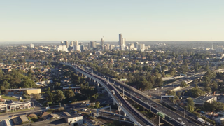
Parramatta is a major commercial suburb of the City of Parramatta, in Greater Sydney which is located in the state of New South Wales, Australia. It is located approximately 23 kilometres (14 mi) west of the Sydney central business district on the banks of the Parramatta River. Parramatta is the administrative seat of the City of Parramatta and is often regarded as commercial centre for both the Greater Parramatta region as well as the broader Greater Western Sydney region.
Young is a town in the South West Slopes region of New South Wales, Australia and the largest town in the Hilltops Region. The "Lambing Flat" Post Office opened on 1 March 1861 and was renamed "Young" in 1863.

Queanbeyan is a city in south-eastern region of the Australian state of New South Wales, located adjacent to the Australian Capital Territory in the Southern Tablelands region. Located on the Queanbeyan River, the city is the council seat of the Queanbeyan-Palerang Regional Council. At the 2016 census, the Queanbeyan part of the Canberra–Queanbeyan built-up area had a population of 36,348.

Forbes is a town in the Central West region of New South Wales, Australia, located on the Newell Highway between Parkes and West Wyalong. At the 2016 census, Forbes had a population of 8,432. Forbes is probably named after Sir Francis Forbes, first Chief Justice of NSW.

Windsor is a historic town north-west of Sydney, New South Wales, Australia. It is in the Hawkesbury local government area. The town sits on the Hawkesbury River, enveloped by farmland and Australian bush. Many of the oldest surviving European buildings in Australia are located at Windsor. It is 46 kilometres (29 mi) north-west of metropolitan Sydney, on the fringes of urban sprawl.
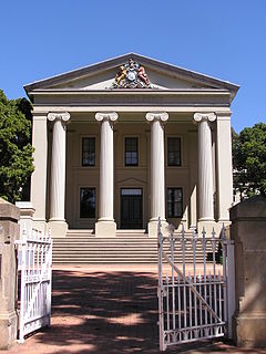
Francis Howard Greenway was an English-born architect who was transported to Australia as a convict for the crime of forgery. In New South Wales he worked for the Governor, Lachlan Macquarie, as Australia's first government architect. He became widely known and admired for his work displayed in buildings such as St Matthew's Church in Windsor, New South Wales, St James' Church, Sydney and Hyde Park Barracks, Sydney.

Muswellbrook is a town in the Upper Hunter Region of New South Wales, Australia, about 243 km (151 mi) north of Sydney and 127 km (79 mi) north-west of Newcastle.

Kempsey is a town in the Mid North Coast region of New South Wales, Australia and is the council seat for Kempsey Shire. It is located 15 kilometres inland from the coast of the Pacific Ocean, on the Macleay Valley Way near where the Pacific Highway and the North Coast railway line cross the Macleay River. It is roughly 345 kilometres north of Sydney. As at June 2018 Kempsey had a population of 15,309.
Pambula is a town in Bega Valley Shire on the far south coast of New South Wales, Australia 473 kilometres (294 mi) south of Sydney via the Princes Highway. At the 2016 census, Pambula had a population of 970 people.

The City of Penrith is a local government area in the state of New South Wales, Australia. The seat of the city is located in Penrith, located about 50 kilometres (31 mi) west of Sydney's central business district. It occupies part of the traditional lands of the Darug people. First incorporated as a municipality on 12 May 1871, on 1 January 1949, the municipalities of Penrith, St Marys and Castlereagh and part of the Nepean Shire amalgamated to form a new Municipality of Penrith. Penrith was declared a City on 21 October 1959, and expanded westwards to include Emu Plains and Emu Heights, formerly part of the City of Blue Mountains, on 25 October 1963. As at the 2016 census the City of Penrith had an estimated population of 196,066.

New Farm is an inner northern riverside suburb of the City of Brisbane, Queensland, Australia. In the 2016 census, New Farm had a population of 12,542 people.

Castlereagh is a suburb of Sydney, in the state of New South Wales, Australia. Castlereagh is 67 kilometres (42 mi) north-west of the Sydney central business district, in the local government area of the City of Penrith and is part of the Greater Western Sydney region.

Narooma is a town in the Australian state of New South Wales on the far south coast. The town is on the Princes Highway and the name Narooma is said to be derived from the Aboriginal word meaning ‘clear blue waters’. At the 2016 census, Narooma had an urban population of over 3,000 people.

Wollondilly Shire is a periurban local government area adjacent to the south-western fringe of Sydney, parts of which fall into the Macarthur, Blue Mountains and Central Tablelands regions in the state of New South Wales, Australia. Wollondilly Shire was created by proclamation in the NSW Government Gazette on 7 March 1906, following the passing of the Local Government (Shires) Act 1905, and amalgamated with the Municipality of Picton on 1 May 1940.

Tenterfield Shire is a local government area located in the New England region of New South Wales, Australia. The Shire is situated adjacent to the New England Highway.
Kooragang is the northernmost and largest suburb of the city of Newcastle, in the Hunter Region of New South Wales, Australia. Dominated by Kooragang Island, the eastern part of the suburb is primarily industrial, while the western part of the suburb consists of nature reserves. Covering an area of 35.4 km2 (13.7 sq mi), at the 2016 census, there were no people living in the suburb.

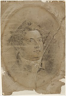
Francis Armand Bland, CMG was an Australian politician.
Yowaka River, a perennial river of the Pambula River catchment, is located in the South Coast region of New South Wales, Australia.

The Snowy Monaro Regional Council is a local government area located in the Snowy Mountains and Monaro regions of New South Wales, Australia. The council was formed on 12 May 2016 through a merger of the Bombala, Cooma-Monaro and Snowy River shires.
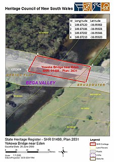
The Yowaka River bridge is a heritage-listed road bridge that carries the Princes Highway across the Yowaka River at Greigs Flat on the Bega Valley Shire local government area of New South Wales, Australia. It was built in 1936. The bridge is also known as the Yowaka Bridge near Eden. The property is owned by Roads and Maritime Services, an agency of the Government of New South Wales. It was added to the New South Wales State Heritage Register on 20 June 2000.
