Lachlan Valley Way

Last updated

Lachlan Valley Way

Australia New South Wales location map blank.svg
Red pog.svg
West end
Red pog.svg
East end
Coordinates
General information
TypeRural road
Length568 km (353 mi) [1]
Gazetted August 1928 [2]
Route number(s) AUS Alphanumeric Route B81.svg B81 (2013–present)
(Cowra–Bowning)
Former
route number
Australian state route 81.svg State Route 81 (1974–2013)
(Cowra–Bowning)
Major junctions
West endAUS Alphanumeric Route B75.svg Cobb Highway
Booligal, New South Wales
 
East endAUS Alphanumeric Route M31.svg Hume Highway
Bowning, New South Wales
Location(s)
Major settlements Hillston, Lake Cargelligo, Condobolin, Forbes, Gooloogong, Cowra, Boorowa
Road entry sign to Boorowa on Lachlan Valley Way Superb parrot boorowa welcome sign.JPG
Road entry sign to Boorowa on Lachlan Valley Way

Lachlan Valley Way is a New South Wales country road running from Booligal to north of Yass. It was named after the Lachlan River, and follows its southern bank for the majority of its length.

Contents

Route

Lachlan Valley Way commences at the intersection with Cobb Highway in Booligal and heads in a north-easterly direction for about 76 km (47 mi) to Hillston. It then follows the Kidman Way (B87) to the east and north-east for about 35 km (22 mi) before turning off to the east and proceeding a further 57 km (35 mi) to Lake Cargelligo. From there it continues to the north and east through Euabalong to Condobolin. This 93 km (58 mi) section of road has three named parts, from west to east. They are Lake Cargelligo-Euabalong Road, Lachlan Valley Way, and Condobolin-Lake Cargelligo Road. From Condobolin the Lachlan Valley Way turns south-east towards Forbes, a further 98 km (61 mi). From Forbes it continues south-east through Gooloogong to Cowra, a further 90 km (56 mi). It then turns south through Boorowa, to end after another 119 km (74 mi) at the Hume Highway north-west of Yass.

History

The passing of the Main Roads Act of 1924 [3] through the Parliament of New South Wales provided for the declaration of Main Roads, roads partially funded by the State government through the Main Roads Board (later the Department of Main Roads, and eventually Transport for NSW). Main Road No. 56 was declared along this road from Forbes, via Cowra to Yass (and continuing northwards via Parkes, Dubbo, Gilgandra and Coonamble eventually to Walgett, and southwards via Canberra eventually to the intersection with Queanbeyan-Braidwood Road, today Kings Highway, at Queanbeyan), [2] Main Road No. 61 from Condoblin to Forbes (and continuing eastwards via Eugowra and Cudal to the intersection with North-Western Highway, today Mitchell Highway, at Orange) [2] and Main Road No. 230 from Lake Cargelligo via Euabalong to Condobolin, [2] on the same day, 8 August 1928. With the passing of the Main Roads (Amendment) Act of 1929 [4] to provide for additional declarations of State Highways and Trunk Roads, these were amended to Trunk Roads 56 and 61 and Main Road 230 on 8 April 1929.

The southern end of Trunk Road 56 was truncated at Bowning when the delaration of State Highway 15 (later named Barton Highway subsumed the former alignment on 19 February 1935; [5] and the northern end was truncated to Forbes when the declaration of State Highway 17 (later named Newell Highway) subsumed the former alignment on 16 March 1938. [6] Trunk Road 61 was re-aligned to run between Orange and Condobolin via Parkes on 6 April 1938; its former alignment between Condobolin and Forbes (and continuing east via Eugowra and Cudal to Orange) was replaced by Main Road 377. [7] Main Road 501 was declared between Lake Cargelligo via Hillston to the intersection with State Highway 21 (later named Cobb Highway) in Booligal on 17 May 1939. [8]

The route - from Booligal to Bowning, along Trunk Road 56 and Main Roads 230 and 377 and 501 - was named Lachlan Valley Way on 23 September, 1970. [9] Main Road 230 had its declaration revoked on 15 March 1996, [10] but the road is still generally known as a part of Lachlan Valley Way despite this. Main Road 501 was divided into two sections between Hillston and Wallanthery, with Main Road 410 (Kidman Way) subsuming the former alignment and officially splitting Lachlan Valley Way into a western section terminating at Hillston, and an eastern section terminating in Wallanthery, on 12 March 2010. [11]

The passing of the Roads Act of 1993 [12] updated road classifications and the way they could be declared within New South Wales. Under this act, Lachlan Valley Way today retains its declaration as part of Main Road 377, and as Main Roads 56 and 501, from Booligal to Hillston, then from Wallanthery to Lake Cargelligo, then from Condoblin via Forbes, Cowra and Boorowa to Bowning. [13]

Lachlan Valley Way was signed State Route 81 between Cowra and Bowning in 1974. With the conversion to the newer alphanumeric system in 2013, this was replaced with route B81. [14]

Major intersections

LGALocationkm [1] miDestinationsNotes
Hay Booligal 0.00.0AUS Alphanumeric Route B75.svg Cobb Highway (B75)  Ivanhoe, Wilcannia, Hay, Deniliquin Western terminus of Lachlan Valley Way
Carrathool Hillston 76.247.3AUS Alphanumeric Route B87.svg Kidman Way (B87 south)  Goolgowi, Griffith T-intersection
Gap in route
Carrathool Wallanthery110.568.7AUS Alphanumeric Route B87.svg Kidman Way (B87 north)  Cobar T-intersection
Lachlan Lake Cargelligo 167.4104.0Canada Street (Condobolin-Lake Cargelligo Road) (south)  Condobolin
Foster Street (east) - Lake Cargelligo
4-way intersection
Lachlan River 179.3111.4Bridge over the river (bridge name unknown)
Cobar Euabalong 194.5120.9Lachlan Street (Tipping Way)  Euabalong West, Cobar
Lachlan River194.9121.1Bridge over the river (bridge name unknown)
Lachlan Euabalong 199.7124.1Condobolin-Lake Cargelligo Road  Lake Cargelligo
Condobolin 259.8161.4Condobolin-West Wyalong Road (The Gipps Way south)  West Wyalong
260.9162.1William Street (The Gipps Way north)  Condobolin, Parkes T-intersection
Forbes Bundaburrah352.8219.2AUS Alphanumeric Route A39.svg Newell Highway (A39 south)  West Wyalong Western concurrency terminus with route A39 at T-intersection
Lachlan River356.9221.8Bridge over the river (bridge name unknown)
Lake Forbes358.6222.8 Oxley Bridge
Forbes Forbes 359.1223.1AUS Alphanumeric Route A39.svg Newell Highway (A39 north)  Parkes Eastern concurrency terminus with route A39 at T-intersection
Lake Forbes359.4223.3Bridge over the river (bridge name unknown)
Forbes Forbes 359.8223.6Bridge Street (The Escort Way) (east)  Cudal, Orange
Flint Street (north)  Forbes
Roundabout
Lachlan River361.3224.5Bridge over the river (bridge name unknown)
Forbes Forbes 363.9226.1 Henry Lawson Way   Grenfell, Young
Cowra Gooloogong 410.4255.0Nanima Road (north)  Eugowra, Canowindra
Grenfell-Orange Road (south)  Grenfell
Cowra 443.2275.4AUS Alphanumeric Route B64.svg Mid-Western Highway (B64 west)  Grenfell Western concurrency terminus with route B64 at T-intersection
448.5278.7AUS Alphanumeric Route A41.svg Olympic Highway (A41 south)  Young, Junee Eastern concurrency terminus with route B64, western concurrency terminus with route A41
448.6278.7AUS Alphanumeric Route A41.svgAUS Alphanumeric Route B81.svg Mid-Western Highway (A41/B81 east)  Blayney, Bathurst, Molong Eastern concurrency terminus with route A41 at T-intersection
Route B81 continues east along Mid-Western Highway
Hilltops Boorowa 521.4324.0Murringo Gap Road  Murringo, Young
Yass Valley Bowning 567.9352.9AUS Alphanumeric Route M31.svg Hume Freeway (M31)  Gundagai, Albury, Yass, Goulburn Eastern terminus of Lachlan Valley Way, southern terminus of route B81

See also

Related Research Articles

<span class="mw-page-title-main">Newell Highway</span> Highway in New South Wales, Australia

Newell Highway is a national highway in New South Wales (NSW), Australia. It provides the major road link between southeastern Queensland and Victoria via central NSW and as such carries large amounts of freight. At 1,058 kilometres (657 mi) in length, the Newell is the longest highway in NSW, and passes through fifteen local government areas.

<span class="mw-page-title-main">Golden Highway</span> Highway in New South Wales

Golden Highway is a 313-kilometre (194 mi) highway, located in the Hunter and Orana regions of New South Wales, Australia. It runs eastwards from Dubbo towards Newcastle on the coast, allowing road transport to avoid travelling over the Blue Mountains to Sydney, and is designated route B84.

<span class="mw-page-title-main">Cobb Highway</span>

Cobb Highway is a state highway in the western Riverina and the far western regions of New South Wales, with a short section in Victoria, Australia, designated part of route B75.

<span class="mw-page-title-main">Barton Highway</span>

Barton Highway is a highway in New South Wales and the Australian Capital Territory. It connects Canberra to Hume Highway at Yass, and it is part of the route from Melbourne to Canberra. It is named in honour of Sir Edmund Barton, the first Prime Minister of Australia.

<span class="mw-page-title-main">Lachlan River</span> Intermittent river in New South Wales, Australia

The Lachlan River is an intermittent river that is part of the Murrumbidgee catchment within the Murray–Darling basin, located in the Southern Tablelands, Central West, and Riverina regions of New South Wales, Australia.

<span class="mw-page-title-main">Mid-Western Highway</span> Highway in New South Wales

Mid-Western Highway, sometimes Mid Western Highway, is a 518-kilometre (322 mi) state highway located in the central western and northern Riverina regions of New South Wales, Australia. The highway services rural communities and links the Great Western, Mitchell, Olympic, Newell, Cobb and Sturt highways. Mid-Western Highway forms part of the most direct route road link between Sydney and Adelaide, with its eastern terminus in Bathurst and western terminus in Hay. It is designated part of route A41 between Bathurst and Cowra, and route B64 between Cowra and Hay.

<span class="mw-page-title-main">Castlereagh Highway</span> Highway in New South Wales and Queensland, Australia

Castlereagh Highway is a 790-kilometre (490 mi) state highway located in New South Wales and Queensland, Australia. From north to south the highway traverses South West Queensland and the North West Slopes, Orana, and Central West regions of New South Wales.

<span class="mw-page-title-main">Olympic Highway</span> Highway in New South Wales

Olympic Highway is a 317-kilometre (197 mi) rural road in the central western and south-eastern Riverina regions of New South Wales, Australia. It services rural communities, links Hume Highway with Mid-Western Highway, and provides part of an alternate road link between Sydney and Albury via Bathurst and Cowra as well as servicing Wagga Wagga, linking with Sturt Highway.

<span class="mw-page-title-main">Wyangala Dam</span> Dam in New South Wales, Australia

Wyangala Dam is a major gated rock fill with clay core embankment and gravity dam with eight radial gates and a concrete chute spillway across the Lachlan River, located in the south-western slopes region of New South Wales, Australia. The dam's purpose includes flood mitigation, hydro-power, irrigation, water supply and conservation. The impounded reservoir is called Lake Wyangala.

<span class="mw-page-title-main">Burley Griffin Way</span> Highway in New South Wales, Australia

Burley Griffin Way is a New South Wales state route, is located in south eastern Australia. Named after the American architect Walter Burley Griffin, designer of the cities of Canberra and Griffith, the road links these two cities via Yass and Barton Highway.

<span class="mw-page-title-main">Kidman Way</span> Highway in New South Wales

Kidman Way is a state rural road in the western Riverina and western region of New South Wales, Australia. The 643-kilometre (400 mi) highway services the Murrumbidgee Irrigation Area and outback communities and links the Newell Highway with the Sturt, Mid-Western, Barrier, Mitchell and Kamilaroi highways. The road is designated route B87 for its entire length, with its northern terminus at Bourke and its southern terminus just north of Jerilderie. Kidman Way is fully sealed and is accessible by two or four-wheel drive.

<span class="mw-page-title-main">Bucketts Way</span> Road in New South Wales, Australia

(The) Bucketts Way is a 151-kilometre (94 mi) rural road that links Gloucester to Taree and Raymond Terrace, in New South Wales, Australia. A former alignment of Pacific Highway, it was later named after the Bucketts Mountains, a prominent mountain range near Gloucester. The entire route is designated as Tourist Route 2.

<span class="mw-page-title-main">Irrigation Way</span>

Irrigation Way is a major rural road that runs approximately 85 kilometres (53 mi) through the Murrumbidgee Irrigation Area in south western New South Wales, Australia.

<span class="mw-page-title-main">Mount Hope, New South Wales</span> Town in New South Wales, Australia

Mount Hope is a settlement in western New South Wales, Australia. It is situated on the Kidman Way, 95 kilometres north of Hillston and 160 km south of Cobar. A government township called 'Nombinnie' was surveyed in the mid-1880s but that name was rarely used.

<span class="mw-page-title-main">Central West (New South Wales)</span> Region in New South Wales, Australia

The Central West is a region in central New South Wales, Australia. The region is situated west of Sydney, which stretches from Lithgow in the east and to as far west as Condobolin, on the Lachlan River. The Central West is known for its agriculture like the Jenolan Caves, near Oberon and also wineries, as well as rural farmland and natural landscapes. The region includes major towns like, Bathurst, Orange, Mudgee, Lithgow, Parkes and Cowra. It has an area of 63,262 square kilometres (24,426 sq mi). The region also includes the sub-region known as the Central Tablelands, located in the eastern part of the region. The region known as the Orana, which includes the area surrounding Dubbo can be classed as being a part of the Central West also.

<span class="mw-page-title-main">Goldfields Way</span>

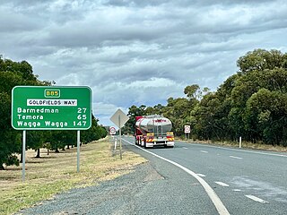
Goldfields Way is a 116-kilometre (72 mi) country road in the northern part of the Riverina region of New South Wales, connecting Wyalong via Temora to Old Junee.

Escort Way is a 114-kilometre (71 mi) country road in New South Wales running from Mitchell Highway in Orange to Lachlan Valley Way in Forbes. The name derives from the notorious hold up of the Lachlan Gold Escort by bushrangers in 1862 which occurred along the route, and subsequent lobbying by the Canowindra Historical Society to recognise this. Escort Rock, a heritage-listed geological formation is located adjacent to the road near Eugowra.

<span class="mw-page-title-main">Euabalong</span> Town in New South Wales, Australia

Euabalong is a town in western New South Wales, Australia. The town is in the Cobar Shire local government area and on the Lachlan River, 531 kilometres (330 mi) west of the state capital, Sydney, and 27 kilometres from Lake Cargelligo. At the 2016 census, Euabalong had a population of 188.

Matakana is a rural locality in western New South Wales, Australia. It is situated just off the Kidman Way, 78 kilometres north of Hillston and 177 kilometres south of Cobar. The small settlement of Mount Hope is located 17 kilometres to the north on the Kidman Way.

Henry Parkes Way is a 171-kilometre (106 mi) country road in New South Wales, Australia, running from Condobolin via Parkes to Escort Way in Boree. It is named after Henry Parkes, a long-serving premier of the Colony of New South Wales, and promoter for the federation of the six colonies of Australia.

References

  1. 1 2 Google (13 August 2022). "Lachlan Valley Way" (Map). Google Maps . Google. Retrieved 13 August 2022.
  2. 1 2 3 4 "Main Roads Act, 1924-1927". Government Gazette of the State of New South Wales. No. 110. 17 August 1928. pp. 3814–20. Archived from the original on 3 August 2022. Retrieved 1 August 2022 via National Library of Australia.
  3. State of New South Wales, An Act to provide for the better construction, maintenance, and financing of main roads; to provide for developmental roads; to constitute a Main Roads Board Archived 11 August 2022 at the Wayback Machine 10 November 1924
  4. State of New South Wales, An Act to amend the Main Roads Act, 1924-1927; to confer certain further powers upon the Main Roads Board; to amend the Local Government Act, 1919, and certain other Acts; to validate certain payments and other matters; and for purposes connected therewith. Archived 12 August 2022 at the Wayback Machine 8 April 1929
  5. "Main Roads Act, 1924-1931". Government Gazette of the State of New South Wales. No. 53. National Library of Australia. 8 March 1935. p. 1038. Archived from the original on 26 August 2022. Retrieved 26 August 2022.
  6. "Main Roads Act, 1924-1937". Government Gazette of the State of New South Wales. No. 58. National Library of Australia. 14 April 1938. pp. 1525–6. Archived from the original on 29 August 2022. Retrieved 29 August 2022.
  7. "Main Roads Act, 1924-1937". Government Gazette of the State of New South Wales. No. 58. National Library of Australia. 14 April 1938. p. 1526. Archived from the original on 29 August 2022. Retrieved 25 November 2022.
  8. "Main Roads Act, 1924-1938". Government Gazette of the State of New South Wales. No. 80. National Library of Australia. 26 May 1939. p. 2726. Archived from the original on 30 November 2022. Retrieved 30 November 2022.
  9. "Main Roads Act, 1924". Government Gazette of the State of New South Wales. No. 133. National Library of Australia. 9 October 1970. p. 4042. Archived from the original on 25 November 2022. Retrieved 25 November 2022.
  10. "Roads Act". Government Gazette of the State of New South Wales. No. 33. National Library of Australia. 15 March 1996. p. 1153. Archived from the original on 25 November 2022. Retrieved 25 November 2022.
  11. "Roads Act 1993" (PDF). Government Gazette of the State of New South Wales. No. 38. Legislation NSW. 12 March 2010. pp. 1252–3. Archived (PDF) from the original on 30 November 2022. Retrieved 30 November 2022.
  12. State of New South Wales, An Act to make provision with respect to the roads of New South Wales; to repeal the State Roads Act 1986, the Crown and Other Roads Act 1990 and certain other enactments; and for other purposes. Archived 11 August 2022 at the Wayback Machine 10 November 1924
  13. Transport for NSW (August 2022). "Schedule of Classified Roads and Unclassified Regional Roads" (PDF). Government of New South Wales. Archived from the original (PDF) on 25 August 2022. Retrieved 1 August 2022.
  14. "Road number and name changes in NSW" (PDF). Roads & Maritime Services . Government of New South Wales. 2012. Archived from the original (PDF) on 25 March 2016. Retrieved 7 November 2016.