
Coffs Harbour, locally nicknamed Coffs, is a coastal city on the Mid North Coast of New South Wales, Australia, 540 km (340 mi) north of Sydney, and 390 km (240 mi) south of Brisbane. It is one of the largest urban centres on the North Coast, with a population of 78,759 as per 2021 census. The Gumbaynggirr are the original people of the Coffs Harbour region.

Middle Harbour, a semi–mature tide dominated drowned valley estuary, is the northern arm of Port Jackson, an inlet of the Tasman Sea located north of Sydney central business district on the coast of New South Wales, Australia.

The Tweed River is a river situated in the Northern Rivers region of New South Wales, Australia. From the middle reaches of its course, the state boundary between New South Wales and Queensland is located approximately 10 kilometres (6.2 mi) north.

The Mid North Coast is a country region in the north-east of the state of New South Wales, Australia. The region is situated 416km north of Sydney, covers the mid northern coast of the state, beginning from Port Stephens at Hawks Nest to as far north as Woolgoolga, near Coffs Harbour. The region has heaps of beaches and many subtropical national parks and forests as well as rural farmland and logging. Major coastal towns include Coffs Harbour, Forster and Port Macquarie. The Mid North Coast is a popular destination for camping or resorts and surfing, with coastal and hinterland tracks.

Bellingen is a small town in the Mid North Coast of New South Wales, Australia. It is located on Waterfall Way on the Bellinger River, approximately halfway between the major Australian cities of Sydney and Brisbane. In 2021, the population of Bellingen township was 3,923 and Bellingen shire was 13,253, and it is the council seat of Bellingen Shire.

The Towra Point Nature Reserve is a protected nature reserve that is located in Sutherland Shire, southern Sydney, New South Wales, in eastern Australia. The 603-hectare (1,490-acre) reserve is situated on the southern shores of Botany Bay at Kurnell, within the Sutherland Shire. The reserve is protected under the Ramsar Convention as a wetland of international importance as an important breeding ground for many vulnerable, protected, or endangered species. The Towra Point Aquatic Nature Reserve is located in the surrounding waterways.

Pittwater is a semi-mature tide dominated drowned valley estuary, located about 40 kilometres (25 mi) north of the Sydney central business district, New South Wales, Australia; being one of the bodies of water that separate greater Metropolitan Sydney from the Central Coast.

Crescent Head is a town on the Mid North Coast, 340 km north-northeast of Sydney, in The Kempsey Shire local government area of New South Wales, Australia. At the 2011 census, Crescent Head had a population of 1,586 people. Its major industries include tourism and fishing. It has a 6-hole golf course overlooking the sea.

Nambucca Heads is a town on the Mid North Coast of New South Wales, Australia in the Nambucca Valley. It is located on a ridge, north of the estuary of the Nambucca River near the Pacific Highway. Its 2021 population was 6,675, including 5,226 (78.3%) Australian-born persons and 672 indigenous persons.

Bellingen Shire is a local government area in the Mid North Coast region of New South Wales, Australia. The shire is located adjacent to the Pacific Highway, Waterfall Way and the North Coast railway line.

Hat Head is a coastal town on the mid-northern coast of New South Wales, 459 kilometres north of Sydney, Australia, and in the Hat Head National Park. At the time of the 2011 census, Hat Head had a population of 326 people.

Scotts Head is a coastal village of the Nambucca Valley local government area in the Mid North Coast region of New South Wales, Australia. Located on the coast of the Pacific Ocean, approximately 10 kilometres (6 mi) from the Pacific Highway and 480 kilometres (300 mi) from Sydney, it stretches southwards from just south of the mouth of the Nambucca River to the town of Scotts Head in the south.
The Gumbaynggirr people, also rendered Kumbainggar, Gumbangeri and other variant spellings, are an Aboriginal Australian people of the Mid North Coast of New South Wales. Gumbathagang was a probable clan or sub-group. The traditional lands of the Gumbaynggirr nation stretch from Tabbimoble Yamba-Clarence River to Ngambaa-Stuarts Point, SWR- Macleay to Guyra and to Oban.
The Bundjalung people are a large Aboriginal nation, a federation of a number of groups of clans which occupy the land from Grafton on the Clarence river of northern New South Wales north to the town of Ipswich and the Beaudesert, in southern Queensland, and down around the other side of the Great Dividing Range and back to Grafton. In the north, Bundjalung Nation shares a border with Yuggera Nation and Barrunggam Nation; to the east the Tasman Sea ; to the south Gumbaynggirr Nation; and to the west it borders Ngarabal Nation.

Oxley is an electoral district of the Legislative Assembly in the Australian state of New South Wales.

The Nambucca and Bellinger News was a weekly English language newspaper published in Bowraville in the Nambucca Shire of New South Wales, Australia from 1911-1945. It was also published as Nambucca News: Bellingen Chronicle,The Nambucca District News,The Nambucca Guardian News,Guardian Gazette and TheNambucca Valley Guardian News.
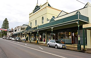
Hammond and Wheatley Commercial Emporium is a heritage-listed commercial building at 69-75 Hyde Street, Bellingen, Bellingen Shire, New South Wales, Australia. It was designed by George Edward Moore and built by Moore from 1908 to 1909. The property is owned by Davpond Pty. Ltd. It was added to the New South Wales State Heritage Register on 2 April 1999.

Limeburners Creek National Park is a protected national park on the Mid North Coast of New South Wales, Australia. The 91.2 km national park is located 5 km (3.1 mi) to the north of Port Macquarie and exists across both the Kempsey Shire and Port Macquarie-Hastings Council local government areas, but is chiefly managed by National Parks and Wildlife Service. The area was originally erected as a nature reserve but this reservation was revoked when it became formally recognised as a national park in 2010 under the National Parks and Wildlife Act (1974). Many threatened ecological habitats and species of fauna and flora are found within this park, alongside several heritage sites of cultural significance, particularly to the local Birpai and Dunghutti people upon whose land the park exists. The protected status of this national park is largely owing to the ecological and cultural value of the area, in addition to the value of the ecosystems to further scientific research.
Giinagay Way is a road in the Mid North Coast region of New South Wales linking the towns of Warrell Creek, Macksville, Nambucca Heads and Urunga to Pacific Highway. It runs along a former section of the highway between Eungai Creek and Raleigh that was bypassed by a new parallel alignment between 2016 and 2018.


