
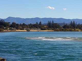
Coffs Harbour, locally nicknamed Coffs, is a coastal city on the Mid North Coast of New South Wales, Australia, 540 km (340 mi) north of Sydney, and 390 km (240 mi) south of Brisbane. It is one of the largest urban centres on the North Coast, with a population of 78,759 as per 2021 census. The Gumbaynggirr are the original people of the Coffs Harbour region.

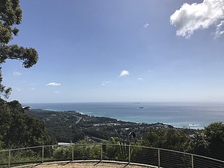
Wollongong, colloquially referred to as The Gong, is a city located in the Illawarra region of New South Wales, Australia. The name is believed to originate from the Dharawal language, meaning either 'five islands/clouds', 'ground near water' or 'sound of the sea'. Wollongong lies on the narrow coastal strip between the Illawarra Escarpment and the Pacific Ocean, 85 kilometres south of central Sydney. Wollongong had an estimated urban population of 302,739 at June 2018, making it the third-largest city in New South Wales after Sydney and Newcastle and the tenth-largest city in Australia by population. The city's current Lord Mayor is Gordon Bradbery AM who was elected in 2021.

Palm Beach is a suburb in the Northern Beaches region of Sydney, in the state of New South Wales, Australia. Palm Beach is located 41 kilometres (25 mi) north of the Sydney central business district, in the local government area of Northern Beaches Council. Palm Beach sits on a peninsula at the end of Barrenjoey Road near Pittwater and is the northernmost beach in the Greater Sydney Metropolitan area. The population of Palm Beach was 1,593 as at the 2016 census.

Port Kembla is a suburb of Wollongong 10 km south of the CBD and part of the Illawarra region of New South Wales. The suburb comprises a seaport, industrial complex, a small harbour foreshore nature reserve, and a small commercial sector. It is situated on the tip of Red Point: its first European sighting was by Captain James Cook in 1770. The name "Kembla" is an Aboriginal word meaning "plenty [of] wild fowl".

The Mid North Coast is a country region in the north-east of the state of New South Wales, Australia. The region, situated 416km north of Sydney, covers the mid northern coast of the state, beginning from Port Stephens at Hawks Nest to as far north as Woolgoolga, near Coffs Harbour. The region has heaps of beaches and many subtropical national parks and forests as well as rural farmland and logging. Major coastal towns include Coffs Harbour, Forster and Port Macquarie. The Mid North Coast is a popular destination for camping or resorts and surfing, with coastal and hinterland tracks.

Queenscliff is a suburb of northern Sydney, in the state of New South Wales, Australia. Queenscliff is located 16 kilometres north-east of the Sydney central business district, in the local government area of Northern Beaches Council and is part of the Northern Beaches region.

Bilgola Beach is a suburb in northern Sydney, in the state of New South Wales, Australia 33 kilometres north-east of the Sydney central business district, in the local government area of Northern Beaches Council. It is part of the Northern Beaches region. It and Bilgola Plateau were gazetted as suburbs in 2012 dividing the previous suburb of Bilgola.

Wamberal is a coastal suburb of the Central Coast region of New South Wales, Australia, just north of Terrigal. It is part of the Central Coast Council local government area and is located adjacent to the Wamberal Lagoon. Wamberal is an Aboriginal word meaning 'where the sea breaks'.
Urunga is a small town located within the Mid North Coast region of New South Wales, Australia, in Bellingen Shire. It is famous for its surf spots. At the 2021 census, Urunga had a population of 3,185. The town is south of Coffs Harbour and Sawtell and north of Nambucca Heads. The place name is derived from the Gumbaynggir word Yurūnga, which is derived from the word for long yurūn in reference to "long white sands".

The AFL North Coast is a park Australian rules football competition in the Mid North Coast region of New South Wales. Founded in 1982 as The North Coast Australian Football League it merged with the junior league in its area in 2008 and was renamed AFL North Coast.
Toormina is a suburb in the City of Coffs Harbour, on the east coast of New South Wales, Australia. Located in the city's south, Toormina is near the seaside suburb of Sawtell.

Boambee is a suburb in the city of Coffs Harbour on the Mid North Coast of New South Wales, Australia. Boambee is west of Sawtell on the Pacific Highway. It is divided into two sections: semi-rural Boambee (2450) and the more suburban Boambee East (2452). These suburbs are divided by the Pacific Highway. In 2011, Boambee had a population of 1,545 people, while Boambee East had a population of 5,446 people.
Nana Glen is a small village in New South Wales, Australia, located 25 km inland north-west of Coffs Harbour in the City of Coffs Harbour. It is located on the Orara Way and at the juncture of two main roads, one leading to Lower Bucca. The Orara Way is the main thoroughfare through the township and is an alternative route between Grafton and Coffs Harbour. Nana Glen is situated between the township of Coramba and Glenreagh.The local Mayor is Alison Johnson MD.

The City of Coffs Harbour is a local government area in the mid north coast region of New South Wales, Australia. The area under administration is 1,175 square kilometres (454 sq mi), expanded in 2004 to take in parts of the former Pristine Waters local government area.

Woolgoolga is a town on the Mid North Coast of New South Wales, Australia. It is on the Pacific Highway, approximately 550 km north of Sydney and 365 km south of Brisbane. The closest city to Woolgoolga is Coffs Harbour, which lies 24.8 km to the south. Woolgoolga has two beaches on the Pacific Ocean. The area has long been a centre of banana growing in New South Wales, but this industry has declined in the face of competition from Queensland. Recent times have seen many banana plantations replaced by blueberries after banana sales slumped in the late 1990s.
Red Rock is a small hamlet in the northern beaches of the Coffs Harbour coast beside the banks of the Corindi River on the Mid North Coast of New South Wales, Australia, and is surrounded by National Parks. It is in the City of Coffs Harbour local government area. At the 2016 census, Red Rock had a population of 303 people. The small Red Rock River passes near the town.

Scotts Head is a coastal village of the Nambucca Valley local government area in the Mid North Coast region of New South Wales, Australia. Located on the coast of the Pacific Ocean, approximately 10 kilometres (6 mi) from the Pacific Highway and 480 kilometres (300 mi) from Sydney, it stretches southwards from just south of the mouth of the Nambucca River to the town of Scotts Head in the south.

Park Beach is a suburb of Coffs Harbour, northern New South Wales, located in the north eastern part of the town. It has a population of around 5,000 which swells during summer as it is a coastal tourist destination containing many motels, backpackers and other forms of accommodation. The suburb of Park Beach is generally considered to be the area within the Ocean Parade and Orlando Street intersection at the south, the Orlando Street and Woolgoolga Road intersection, the turnoff from the Pacific Highway onto Macauleys Headland Drive, and the southern end of the Coffs Coast Regional Park.

Cabarita Beach is a town in northeastern New South Wales which occupies a thin strip of beach-side land along the Coral Sea coast, east of Tweed Coast Road, in the Tweed Shire town of Bogangar. Locally, the names Cabarita Beach and Bogangar are interchangeable; either may be used when referring to the whole settlement, with more people using the former. Hastings Point lies close to Cabarita Beach to the south and Casuarina to the north. At the 2016 census Cabarita Beach had a population of 103, Bogangar 3060. Cabarita Beach is located within the Tweed Shire Local Government Authority.
Korora is a suburb of the City of Coffs Harbour in New South Wales, Australia, located 6 km north of the city centre. Korora is located in a basin that runs from the foothills of the Great Dividing Range in the west to Korora Bay in the east. It is bisected by the Pacific Highway, which runs south to north between Sydney and Brisbane. The section of Korora between the Pacific Highway and the coast is mainly residential, with some tourist facilities. The section west of the Highway consists of larger residential blocks and farms growing mainly bananas and blueberries. The west-most section of Korora is forested and includes part of the Ulidarra National Park. The Korora basin is drained by creeks that flow into Pine Brush Creek and enter the sea at Hills Beach.


