Related Research Articles
Taree is a city on the Mid North Coast, New South Wales, Australia. Taree and nearby Cundletown were settled in 1831 by William Wynter. Since then Taree has grown to a population of 26,381, and is the centre of a significant agricultural district. Situated on a floodplain by the Manning River, it is 16 km from the Tasman Sea coast, and 317 km north of Sydney.
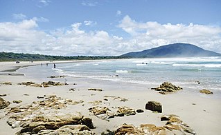
Old Bar is a coastal town in New South Wales, Australia in Mid-Coast Council. It lies around 16 kilometres (10 mi) east of Taree on the Mid North Coast, and around 315 kilometres (196 mi) north of Sydney.
Tinonee is a small town on the banks of the Manning River, near Taree on the Mid North Coast of New South Wales in Mid-Coast Council, Australia. Tinonee was founded in 1854 and in the late 1980s became part of Greater Taree City. At the 2006 census, Tinonee had a population of 734 people.

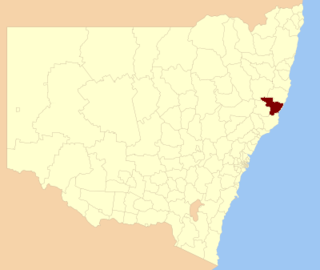
The Division of Lyne is an Australian electoral division in the state of New South Wales.
The Greater Taree City Council (GTCC) was a local government area on the Mid North Coast of New South Wales, Australia, until 12 May 2016 when it was amalgamated to form part of the Mid-Coast Council. It was originally formed in 1981 from the Manning Shire, and the Taree and Wingham Municipal Councils. The council was centred on Taree, located adjacent to the Manning River, the Pacific Highway and the North Coast railway line.

Three Brothers, three separate mountains of the Mid North Coast region of New South Wales, Australia, are situated approximately 360 kilometres (220 mi) north of Sydney.
Lansdowne is a rural village on the Mid North Coast near Taree in New South Wales, Australia.

Cundletown is a town on the Mid North Coast, New South Wales, Australia. Cundletown and the nearby larger town of Taree were both settled in 1831 by William Wynter. Cundletown had a population of 2,054 as of the 2016 census. and is a significant agricultural district. It is 16 km from the Tasman Sea coast, and 317 km north of Sydney.

Ellenborough River, a perennial river of the Hastings River catchment, is located in the Mid North Coast region of New South Wales, Australia.
Mummel River, a watercourse of the Manning River catchment, is located in the Northern Tablelands and Mid North Coast districts of New South Wales, Australia.

Stewarts River, a mostly perennial stream of the Mid North Coast region, is located in New South Wales, Australia.
Walcrow River, a watercourse of the Manning River catchment, is located in the Northern Tablelands and Mid North Coast districts of New South Wales, Australia.
Advance was a screw steamer that was wrecked when she sprang a leak whilst carrying tea-tree saplings between Taree, New South Wales and Coopernook. She was lost on the Manning River, New South Wales on 17 June 1933.
Maria River, a watercourse of the Hastings River catchment, is located in the Mid North Coast region of New South Wales, Australia.
Dingo Creek, a perennial stream of the Manning River catchment, is located in the Mid North Coast region of New South Wales, Australia.
Connollys Creek, a watercourse of the Manning River catchment, is located in the Mid North Coast region of New South Wales, Australia.
Cedar Party Creek, a perennial stream of the Manning River catchment, is located in the Mid North Coast region of New South Wales, Australia.

MidCoast Council is a local government area that is located in the Mid North Coast region of New South Wales, Australia. The council was formed on 12 May 2016 through a merger of the Gloucester Shire, Great Lakes and City of Greater Taree Councils.

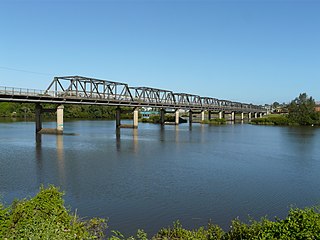
The Manning River railway bridge is a heritage-listed railway bridge that carries the North Coast Line across the Manning River located at Mount George, near Taree in the Mid-Coast Council local government area of New South Wales, Australia. The bridge is also known as the Mount George Rail Bridge over Manning River. The property is owned by Transport Asset Holding Entity, an agency of the Government of New South Wales. It was added to the New South Wales State Heritage Register on 2 April 1999.
Manning Shire was a local government area in the Mid North Coast region of New South Wales, Australia.
References
- ↑ Green, Lauren (21 October 2020). "Sydney development company to transform Kolodong". Manning River Times. Retrieved 11 January 2022.
| | This New South Wales geography article is a stub. You can help Wikipedia by expanding it. |