
Sorell is a town in Tasmania, Australia, north-east of Hobart. It is located on the Tasman Highway at the junction with the Arthur Highway. Sorell is one of Tasmania's oldest towns, being first settled in 1808 as a small farming community and becoming an official township in 1821. At the 2006 census, Sorell had a population of 1,546, and at the 2011 census, a population of 2,476. and at the 2016 census, a population of 2,907.

Bella Vista is located 33 kilometres north-west of the Sydney central business district and is part of The Hills Shire. It is a suburb in the Hills District of Greater Western Sydney and is in the state of New South Wales, Australia. Bella Vista’s Norwest Business Park is home to several Fortune 500 companies, a number of shopping centres, high-rise buildings, and industrial and recreational spaces.

Osborne is a suburb in the Australian state of South Australia located on the LeFevre Peninsula in the west of Adelaide about 21 kilometres north-west of the Adelaide city centre.
Old Bar is a coastal town in New South Wales, Australia in Mid-Coast Council. It lies around 16 kilometres (10 mi) east of Taree on the Mid North Coast, and around 315 kilometres (196 mi) north of Sydney.

Leppington is a suburb of Sydney, in the state of New South Wales, Australia. Leppington is located 38 kilometres south-west of the Sydney central business district, in the local government areas of the City of Liverpool and Camden Council.

Port Macquarie-Hastings Council is a local government area in the Mid North Coast region of New South Wales, Australia.
Kew, New South Wales is a small town in the Mid North Coast region of New South Wales, Australia in the Port Macquarie-Hastings Council local government area. Kew is one of the communities that make up the Camden Haven district of Port Macquarie-Hastings.

Kendall is a town on the Mid North Coast of New South Wales, Australia.
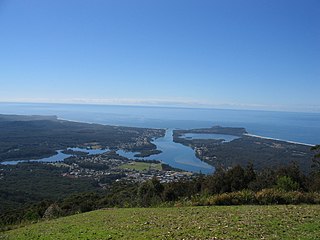
Laurieton is a coastal town on the Mid North Coast of the Australian state of New South Wales. Laurieton is the largest town in the Camden Haven district. Laurieton is 365 km north of Sydney and 42 km south of Port Macquarie. It lies between the base of North Brother Mountain and the Camden Haven River. At the 2016 census, it had a population of 1,986.

Glenelg North is a seaside suburb of Adelaide, South Australia. It is located in both the City of Holdfast Bay and the City of West Torrens.
Myalup is a town located on the coast in the South West region of Western Australia between Mandurah and Bunbury. At the 2006 census, Myalup had a population of 144.

Karuah is a locality in both the Port Stephens and Mid-Coast Councils in the Hunter Region of New South Wales, Australia. It is thought that the name means 'native plum tree' in the local Aboriginal dialect.
Camden Haven High School is a government-funded co-educational comprehensive secondary day school, located in Kew, a village near Laurieton, in the Mid North Coast region of New South Wales, Australia. The school is situated approximately two kilometres east of the Pacific Highway.
Blue Haven is a suburb on the Central Coast of New South Wales, Australia, located on Pacific Highway at Wallarah Creek. Its local government area is Central Coast Council.
Camden Haven is a parish in the Mid North Coast region of New South Wales, Australia, approximately 30 km south of the major regional centre of Port Macquarie. The harbour is located where the Camden Haven River empties into the Tasman Sea.

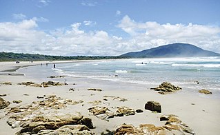
Bonny Hills is a town in New South Wales, Australia on the Tasman Sea coast about 18 km south of Port Macquarie.

Camden Haven River, an open and trained intermediate wave dominated barrier estuary, is located in the Mid North Coast region of New South Wales, Australia.
Stewarts River, a mostly perennial stream of the Mid North Coast region, is located in New South Wales, Australia.
Thone River, a perennial stream of the Hastings River catchment, is located in the Mid North Coast region of New South Wales, Australia.

Krambach is a village in New South Wales, Australia in Mid-Coast Council. The village lies on the Bucketts Way, southwest of Taree on the Mid North Coast. Its population in the 2006 census was 137.

