
Great Lakes Council was a local government area in the Mid North Coast region of New South Wales, Australia. The area is situated adjacent to the shores of Port Stephens, Myall Lakes and Wallis Lake and the Pacific Highway and the Lakes Way. On 12 May 2016 the council was dissolved and the area included in the Mid-Coast Council, along with the City of Greater Taree and Gloucester Shire.

Myall River, an open semi-mature brackish freshwater barrier estuary of the Mid-Coast Council system, is located in the Mid North Coast region of New South Wales, Australia.
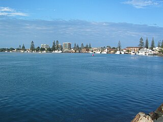
Tuncurry is a coastal town in the Mid North Coast region of New South Wales, Australia, in the Mid-Coast Council LGA, about 307 km (191 mi) north north east of Sydney. It is immediately adjacent to its twin town of Forster, which is the larger of the two towns.
Dawson River, a perennial river of the Manning River catchment, is located in the Mid North Coast district of New South Wales, Australia.
Cells River, a perennial river of the Manning River catchment, is located in the Northern Tablelands and Mid North Coast districts of New South Wales, Australia.
The Crawford River, a perennial river of the Mid-Coast Council system, is located in the Mid North Coast region of New South Wales, Australia.
Doyles River, a perennial river of the Hastings River catchment, is located in the Mid North Coast region of New South Wales, Australia.

Lansdowne River, a watercourse of the Manning River catchment, is located in the Mid North Coast district of New South Wales, Australia.
Mammy Johnsons River, a mostly perennial river of the Mid-Coast Council system, is located in the Mid North Coast and Upper Hunter regions of New South Wales, Australia.

Nowendoc River, a perennial river of the Manning River catchment, is located in the Northern Tablelands and Mid North Coast districts of New South Wales, Australia.
The Pappinbarra River, a perennial stream of the Hastings River catchment, is located in the Mid North Coast region of New South Wales, Australia.
Rowleys River, a perennial river of the Manning River catchment, is located in the Northern Tablelands and Mid North Coast districts of New South Wales, Australia.

Telegherry River, a perennial river of the Mid-Coast Council system, is located in the Mid North Coast and Upper Hunter regions of New South Wales, Australia.
The Branch River, a watercourse of the Mid-Coast Council system, is located in the Mid North Coast and Upper Hunter regions of New South Wales, Australia.

Wallamba River, a watercourse of the Mid-Coast Council system, is located in the Mid North Coast district of New South Wales, Australia.
Wallingat River, a watercourse of the Mid-Coast Council system, is located in the Mid North Coast district of New South Wales, Australia.

Wang Wauk River, a perennial river of the Great Lakes system, is located in the Mid North Coast region of New South Wales, Australia.
Wards River, a mostly perennial river of the Mid-Coast Council system, is located in the Mid North Coast and Upper Hunter regions of New South Wales, Australia.

Wallis Lake, an open and trained wave dominated barrier estuary, is located within the Mid-Coast Council local government area in the Mid North Coast region of New South Wales, Australia. Wallis Lake is located adjacent to the towns of Forster and Tuncurry, and adjacent to the east coast, about 308 kilometres (191 mi) north of Sydney.
The Ralfes Creek, a perennial stream that is part of the Hastings River catchment, is located in the Mid North Coast region of New South Wales, Australia.
