
The local government areas (LGA) of New South Wales in Australia describes the institutions and processes by which areas, cities, towns, municipalities, regions, shires, and districts can manage their own affairs to the extent permitted by the Local Government Act 1993 (NSW).

Hurlstone Park is a suburb in the Inner West of Sydney, New South Wales, Australia. Hurlstone Park is located nine kilometres south-west of the Sydney central business district and is mostly in the local government area of the Canterbury-Bankstown Council, and partly in the Inner West Council. The suburb is bounded by: the Cooks River to the south, Garnet Street to the east, New Canterbury Road to the north, Canterbury Road to the north-west, and Church Street to the west.
Mountain Ash is a town in the Cynon Valley, within the County Borough of Rhondda Cynon Taf, Wales.

The Hills Shire is a local government area in the Greater Western Sydney region of Sydney, New South Wales, Australia. The suburb is north-west of the Sydney central business district, and encompasses 401 square kilometres (155 sq mi) stretching from the M2 Hills Motorway in the south to Wiseman's Ferry on the Hawkesbury River in the north. The Hills Shire had a population of 157,243 as at the 2016 census.

The City of Penrith is a local government area in the state of New South Wales, Australia. The seat of the city is located in Penrith, located about 50 kilometres (31 mi) west of Sydney's central business district.It occupies part of the traditional lands of the Darug people. First incorporated as a municipality on 12 May 1871, on 1 January 1949, the municipalities of Penrith, St Marys and Castlereagh and part of the Nepean Shire amalgamated to form a new Municipality of Penrith. Penrith was declared a City on 21 October 1959, and expanded westwards to include Emu Plains and Emu Heights, formerly part of the City of Blue Mountains, on 25 October 1963. As at the 2016 census the City of Penrith had an estimated population of 196,066.
Mulgoa is a village, located in the local government area of the City of Penrith, in the region of western Sydney, in the state of New South Wales, Australia. Mulgoa is located approximately 66 kilometres (41 mi) west of the Sydney central business district.

Fernhill is a residential district in the Scottish town of Rutherglen in South Lanarkshire. The district is situated south of the River Clyde and borders the Rutherglen neighbourhoods of High Burnside to the north and Cathkin to the east, the Glasgow district of Castlemilk to the west, and the lands of Blairbeth Golf Club to the south.

Glenmore Park is a suburb of Sydney, in the state of New South Wales, Australia. Glenmore Park is located 59 kilometres (37 mi) west of the Sydney central business district, in the local government area of the City of Penrith and is part of the Greater Western Sydney region.

Fernhill railway station is a railway station serving the village of Fernhill in the Cynon Valley, Wales. It is located on the Aberdare branch of the Merthyr Line. Passenger services are provided by Transport for Wales.

Government in the Commonwealth of Australia is exercised on three levels: federal, states and territories, and local government.

Glenworth Valley is a suburb of the Central Coast Council local government area in the Central Coast region of New South Wales, Australia. About 73 km (45 mi) north of Sydney and 20 km (12 mi) west of Gosford, at the 2016 census it had a population of only 10 people.

The City of Lithgow is a local government area in the Central West region of New South Wales, Australia. The area is located adjacent to the Great Western Highway and the Main Western railway line.
Bowenfels is a small town on the western outskirts of Lithgow, New South Wales, Australia.
The Cordeaux River, a perennial river of the Hawkesbury-Nepean catchment, is located in the Southern Highlands and Macarthur regions of New South Wales, Australia.
Edward Cox was an English-born Australian politician.

Mid–Coast Council is a local government area (LGA) located in the Mid North Coast region of New South Wales, Australia. The council was formed on 12 May 2016 through a merger of the Gloucester Shire, Great Lakes and City of Greater Taree councils.

Werri Beach is a town in the Illawarra, south of Kiama and immediately north of Gerringong in New South Wales, Australia. It is located on the coast of the Tasman Sea to the east of the Princes Highway. At the 2016 census, it had a population of 562.
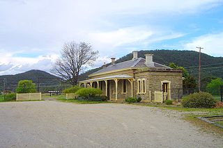
Fernhill is a heritage-listed former chicken hatchery, plant nursery, guest house, farm, residence, stone mason's yard and piggery and now residence and horse stud located at 1041 Mulgoa Road, in the western Sydney suburb of Mulgoa in the City of Penrith local government area of New South Wales, Australia. Completed in c. 1840 as a residence for Captain William Cox and family, the house was completed in the Old Colonial Greek Revival style with its design attributed to either Mortimer Lewis, John Verge or Francis Clarke. The property is privately owned. It was added to the New South Wales State Heritage Register on 2 April 1999.


