Stanwell Park, New South Wales

Last updated

Stanwell Park
Wollongong,  New South Wales
Stanwell Park from Bald Hill.jpg
View from Bald Hill over Stanwell Park valley to Mount Mitchell, and the site of the Sea Cliff Bridge in the background
Australia New South Wales location map blank.svg
Red pog.svg
Stanwell Park
Coordinates 34°13′44″S150°59′00″E / 34.22889°S 150.98333°E / -34.22889; 150.98333 Coordinates: 34°13′44″S150°59′00″E / 34.22889°S 150.98333°E / -34.22889; 150.98333
Population1,410 (2016 census) [1]
Established1824
Postcode(s) 2508
Elevation33 m (108 ft)
Location
LGA(s) City of Wollongong
State electorate(s) Heathcote
Federal division(s) Cunningham
Suburbs around Stanwell Park:
Stanwell Tops Otford
Stanwell ParkPacific Ocean
Coalcliff Pacific Ocean

Stanwell Park is a coastal village and northern suburb of Wollongong, New South Wales, Australia. It is the northernmost point of the Illawarra coastal strip and lies south of Sydney's Royal National Park. It is situated in a small valley between Bald Hill to the north, Stanwell Tops to the west and Mount Mitchell to the south. It has two lagoons from the village's two creeks, Stanwell and Hargrave Creeks and a beach running between headlands. Stanwell Park and the surrounding suburbs are colloquially referred to by its postcode 2508.

Contents

History

The earliest known painting of Stanwell Park, by Henry Grant Lloyd, 1860. (courtesy Mitchell Library) MitchellHouse1860.jpg
The earliest known painting of Stanwell Park, by Henry Grant Lloyd, 1860. (courtesy Mitchell Library)
Stanwell Park beach, circa 1900 Stanwell Park Beach from The Powerhouse Museum.jpg
Stanwell Park beach, circa 1900

Stanwell Park was the name given to the farm established on the grant given to Matthew John Gibbons in 1824. He was given most of the area called Little Bulli which included present-day Stanwell Park and Coalcliff. The whole of Northern Illawarra went under the Aboriginal name Bulli. Bulli remains the name of an Illawarra suburb further south of Stanwell Park.

The area was originally inhabited by the Wodiwodi Aboriginal clan of the Tharawal people. It was traversed by 3 shipwrecked sailors in an epic journey of survival along hundreds of miles of coastline until rescued at Wattamolla, north of Stanwell Park. Two of their companions were unable to negotiate the Coal Cliffs where the Sea Cliff Bridge is today, and their remains were found by explorer George Bass, who also reported on the rich coal seam apparent in the cliffs.

Mr Gibbons installed a convict, John Paid, to manage the Stanwell Park farm. Paid however used the out-of-the-way valley as a hideout for a gang of bushrangers he formed. He adopted the name of Wolloo Jack and his gang terrorised the Bargo to Liverpool area until he and others of the gang were sent to the gallows in 1829.

When Governor Lachlan Macquarie visited Stanwell Park in 1822 he remarked that: "On our arrival at the summit of the mountain, we were gratified with a very magnificent bird's eye view of the ocean, the 5 Islands, and of the greater part of the low country of Illawarra ... After feasting our eyes with this grand prospect, we commenced descending the mountain ... The whole face ... is clothed with the largest and finest forest trees I have ever seen in the colony."

The valley continued to attract notable people: Major Sir Thomas Mitchell, one of Australia's best-known explorers built the first house at Stanwell Park; Supreme Court Judge John Fletcher Hargrave later owned and holidayed in the area, his inheritance coming to Lawrence Hargrave, one of the world's most important aviation pioneers of the 1890s in the lead-up to powered man flight. He performed his most important experiments at Stanwell Park. Lawrence Hargrave moved to Hillcrest House, having inherited it from his brother Ralph Hargrave, in 1893. It is on the road up to the Stanwell Park railway station.

One of the village's most famous attractions is the curved railway viaduct over Stanwell Creek Gorge. It was built in the 1910s when problems with the old railway route forced the construction of a new track higher up the mountainside. At 65 m above the creek bed, surrounded by profuse rainforest vegetation and containing an estimated five million bricks, it is the largest railway viaduct in Australia.

In the 1980s a fatal accident occurred on the railway due to cliff erosion.

Now Stanwell, or The Park, is home to about 1400 people, a dormitory suburb for commuters to the nearby cities of Sydney and Wollongong, and a popular tourist destination.

Heritage listings

Stanwell Park has a number of heritage-listed sites, including:

Population

In the 2016 Census, there were 1,410 people in Stanwell Park. 80.9% of people were born in Australia and 89.3% of people spoke only English at home. The most common responses for religion were No Religion 38.5%, Catholic 22.5% and Anglican 15.4%. [1]

Activities

The village has a small area of shops and an art gallery on Lawrence Hargrave Drive. Bushwalking is possible on several tracks, most notably the Wodi Wodi Track that climbs Mount Mitchell from the station, and a rather degraded track to Stanwell Tops Lookout, also from the station.

Stanwell Park is famous for paragliding and hang gliding activities from Bald Hill down to its beach, which lies nested between high sea cliffs. Rock climbing can be done at Stanwell Tops which offers a view over the village. A feature is the beach with its two lagoons. The Helensburgh-Stanwell Park Surf Life Saving Club (SLSC) offers beach safety and beach activities such as the Nippers on Sundays in summertime. Stanwell Park Arts Theatre, or S.P.A.T (formally Stanwell Park Amateur Theatre) was founded in the early 1970s by Lauren Mitsak, Pam Beckett and others.[ citation needed ] Joy Weidersatz was the first director. The annual Christmas pantomime is popular, though S.P.A.T puts on all types of shows, including Shakespeare, Satire, musicals, theatre restaurant-style shows, revues, etc.

Stanwell Park is serviced by Stanwell Park railway station on the South Coast railway line. The railway bends around the village and crosses Stanwell Creek on a historic brick viaduct.

Bald Hill, at the apex of Lawrence Hargrave Drive, takes in the views of the Northern Illawarra and the escarpment. Whale watching, when in season, captivates many a Sydney day-tripper. The spot is also a notable location for DX radio communication due to its southern and eastern vistas.[ citation needed ]

Attractions

Aerial view from the west Stanwell Park Aerial.jpg
Aerial view from the west

Symbio Wildlife Park is located on Lawrence Hargrave Drive, near the intersection with the Old Princes Highway, at Stanwell Tops. There are over 1000 native, exotic and farmyard animals in all. It has appeared in a Delta Goodrem music video and several television documentaries and is scheduled to appear in the upcoming film Mask 2 . The gardens includes a café, souvenir shop, and free swimming pools and gas barbecues.

Just east of the Symbio Wildlife Gardens, on Lawrence Hargrave Drive, is a turnoff that leads to Sri Venkateswara Hindu Temple. Australia's first Hindu Temple opened on 30 June 1985.[ citation needed ] It is located in Temple Street on a 2.6-hectare (6.4-acre) site. This site was chosen because it fitted the Hindu requirements of a peaceful spot, close to water, elevated, in the bush and on virgin soil. Indian architect Janakiramana Sthapati designed the temple, his family have been temple architects since the sixth century.[ citation needed ]

At Bald Hill is Intabane Mansion, a prominent feature visible from the valley below with a 'witches hat roof', used as an army lookout during World War II. It was originally built in 1917 for the sum of 3000 pounds and became a guest house between the wars.[ citation needed ]

Another attraction is Kelly's Falls, which includes a viewing platform.

Walking tracks include the Stanwell Tops lookout track which runs from Stanwell Park train station up the hillside to the Peace Garden, where there are historic Aboriginal carvings on the trees, and to the Stanwell Tops Lookout. Another track, the Wodi Wodi, Bullock, or Mount Mitchell Track, leads from the former track down to Stanwell Creek, around the viaduct and up Mount Mitchell, then down to the railway and a carpark on Lawrence Hargrave Drive. On the Wodi Wodi track, an aboriginal drawing of a whale can be seen, as well as several middens. Access to Bald Hill from Stanwell Park is available from a track on Chellow Dene Avenue, leading to the top of the hill. [3]

Notable residents

Throughout its history several notable people either originated or spent much of their life in the village. These people have risen to fame through a variety of avenues.

See also

Related Research Articles

<span class="mw-page-title-main">Wollongong</span> City in New South Wales, Australia

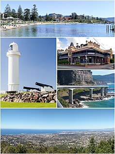
Wollongong, informally referred to as "The Gong", is a city located in the Illawarra region of New South Wales, Australia. The name is thought to be derived from the word woolyungah in the language of the Aboriginal inhabitants at the time of settlement, meaning five islands. Wollongong lies on the narrow coastal strip between the Illawarra Escarpment and the Pacific Ocean, 85 kilometres south of central Sydney. Wollongong had an estimated urban population of 302,739 at June 2018, making it the third-largest city in New South Wales after Sydney and Newcastle and the tenth-largest city in Australia by population. The city's current Lord Mayor is Gordon Bradbery AM who was elected in 2021.

<span class="mw-page-title-main">Bulli, New South Wales</span> Suburb of Wollongong, New South Wales, Australia

Bulli is a northern suburb of Wollongong situated on the south coast of New South Wales, Australia.

<span class="mw-page-title-main">Mount Keira</span> Suburb of Wollongong, New South Wales, Australia

Mount Keira is a suburb and mountain in the Illawarra region of New South Wales, Australia.

<span class="mw-page-title-main">Mount Kembla</span> Suburb of Wollongong, New South Wales, Australia

Mount Kembla is a suburb and a mountain in the Illawarra region of New South Wales, Australia.

<span class="mw-page-title-main">Thirroul, New South Wales</span> Suburb of Wollongong, New South Wales, Australia

Thirroul is a northern seaside suburb of the city of Wollongong, Australia. Situated between Austinmer and Bulli, it is approximately 13 kilometres north of Wollongong, and 73 km south of Sydney. It lies between the Pacific Ocean and a section of the Illawarra escarpment known as Lady Fuller Park, adjacent to Bulli Pass Scenic Reserve.

<span class="mw-page-title-main">South Coast railway line, New South Wales</span> Railway line in New South Wales, Australia

The South Coast Railway is a commuter and goods railway line from Sydney to Wollongong and Bomaderry in New South Wales, Australia. Beginning at the Illawarra Junction, the line services the Illawarra and South Coast regions of New South Wales.

<span class="mw-page-title-main">Otford, New South Wales</span> Suburb of Wollongong, New South Wales, Australia

Otford is a village in the Otford Valley just 55 km to the south of the Sydney metropolitan area and north of the Illawarra and Wollongong in New South Wales, Australia. Otford is within the local government area of Wollongong City Council.

<span class="mw-page-title-main">Stanwell Park railway station</span> Railway station in New South Wales, Australia

Stanwell Park railway station is located on the South Coast railway line in New South Wales, Australia. It serves the seaside village of Stanwell Park opening on 23 December 1901, relocating to its current location on 10 October 1920.

<span class="mw-page-title-main">Bald Hill (Australia)</span> Hill on the Illawarra Range, New South Wales, Australia

Bald Hill is a hill on the Illawarra Range, in the state of New South Wales, Australia. With an elevation of approximately 300 metres (980 ft) AMSL, Bald Hill is one of the best known and most popular lookouts in the Illawarra region providing panoramic vistas across the Illawarra escarpment and over the Illawarra plain and the Tasman Sea of the South Pacific Ocean.

<span class="mw-page-title-main">Illawarra escarpment</span> Mountain range in New South Wales, Australia

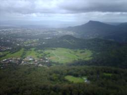
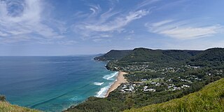
The Illawarra escarpment, or officially the Illawarra Range, is the fold-created cliffs and plateau-eroded outcrop mountain range west of the Illawarra coastal plain south of Sydney, in the state of New South Wales, Australia. The range encloses the Illawarra region which stretches from Stanwell Park in the north to Kiama, Gerringong and the Shoalhaven River in the south.

<span class="mw-page-title-main">Sea Cliff Bridge</span> Bridge in New South Wales, Australia

The Sea Cliff Bridge, together with the adjoining Lawrence Hargrave Drive Bridge, are two road bridges that carry the scenic Lawrence Hargrave Drive across the rockface on the Illawarra escarpment, located in the northern Illawarra region of New South Wales, Australia. The balanced cantilever and incremental launching girder bridges link the coastal villages of Coalcliff and Clifton and carry two lanes of traffic, and a pedestrian walkway.

<span class="mw-page-title-main">Lawrence Hargrave Drive</span>

Lawrence Hargrave Drive, part of the Grand Pacific Drive, is a scenic coastal road and popular tourist drive connecting the northernmost suburbs of Wollongong, New South Wales, Australia, to Wollongong, in the south, and Sydney, in the north. The road was originally constructed in the 1870s as Lower Coast Road, until it was renamed in 1947 after Lawrence Hargrave, an Australian aviation pioneer and explorer who had a house at Stanwell Park and flew his devices from Bald Hill.

<span class="mw-page-title-main">Coalcliff, New South Wales</span> Suburb of Wollongong, New South Wales, Australia

Coalcliff is a town on the coast of New South Wales, Australia, between Sydney and Wollongong.

<span class="mw-page-title-main">Helensburgh, New South Wales</span> Town in New South Wales, Australia

Helensburgh, New South Wales, Australia is a small town, located 45 kilometres south of the Sydney central business district and 35 kilometres (22 mi) north of Wollongong and north and above the Illawarra escarpment and region. Helensburgh is in the Wollongong City Council local government area. It is surrounded by bushland reserves being adjacent to the southern end of the Royal National Park and Garawarra State Conservation Area and the Woronora reservoir water catchment is to its west.

<span class="mw-page-title-main">Clifton, New South Wales</span> Suburb of Wollongong, New South Wales, Australia

Clifton is a village on the coast of New South Wales, Australia, between Sydney and Wollongong. Along with nearby Coalcliff, the village began life as a coal-mining centre. It is situated on a narrow area between the sea and the Illawarra escarpment. The electrified South Coast railway line passes through, but the station at Clifton was closed in 1915. It reopened on 1934-07-04 and closed for the last time on 1983-11-27, at the time of double tracking and electrification.

<span class="mw-page-title-main">Austinmer, New South Wales</span> Suburb of Wollongong, New South Wales, Australia

Austinmer is a northern village of Wollongong on the south coast of New South Wales, Australia. It sits in the northern Illawarra region, south of Stanwell Park and immediately north of Thirroul.

<span class="mw-page-title-main">Geography of Wollongong</span>

The city of Wollongong has a distinct geography. It lies on a narrow coastal plain flanked by the Pacific Ocean to the east and a steep sandstone precipice known as the Illawarra Escarpment to the west, most notably Mount Keira, joined to the escarpment by a high saddle.

Stanwell Tops is an exurban locality between the cities of Sydney and Wollongong on the New South Wales, Australia coastline. It lies northwest of Stanwell Park and southwest of Otford.

The Wodiwodi also pronounced Whardi Whardi peoples are the Indigenous Australian people of New South Wales, a sub-group of the Dharawal nation.

<span class="mw-page-title-main">Stanwell Creek railway viaduct</span> Bridge in New South Wales, Australia

The Stanwell Creek railway viaduct is a heritage-listed railway bridge on the Illawarra railway line at Stanwell Park, City of Wollongong, New South Wales, Australia. It was designed by the New South Wales Government Railways and built in 1920 by day labour. The property is owned by RailCorp, an agency of the Government of New South Wales. It was added to the New South Wales State Heritage Register on 2 April 1999.

References

Citations

  1. 1 2 Australian Bureau of Statistics (27 June 2017). "Stanwell Park (State Suburb)". 2016 Census QuickStats. Retrieved 16 July 2017. OOjs UI icon edit-ltr-progressive.svg CC-BY icon.svg Material was copied from this source, which is available under a [https://creativecommons.org/licenses/by/4.0/ Creative Commons Attribution 4.0 International
  2. "Stanwell Park Rail Viaduct over Stanwell Creek". New South Wales State Heritage Register . Office of Environment & Heritage. H01054. Retrieved 18 May 2018.
  3. Powers, Austin Danger. "Bushwalking for Idiots".

Sources