
The Blue Mountains National Park is a protected national park that is located in the Blue Mountains region of New South Wales, in eastern Australia. The 267,954-hectare (662,130-acre) national park is situated approximately 80 kilometres (50 mi) west of Sydney, and the park boundary is quite irregular as it is broken up by roads, urban areas and inholdings. Despite the name mountains, the area is an uplifted plateau, dissected by a number of larger rivers. The highest point in the park is Mount Werong at 1,215 metres (3,986 ft) above sea level; while the low point is on the Nepean River at 20 metres (66 ft) above sea level as it leaves the park.

Heathcote National Park is a protected national park that is located in the southern region of Sydney, New South Wales in eastern Australia, and is situated on Dharawal country. The 2,679-hectare (6,620-acre) national park is situated approximately 35 kilometres (22 mi) southwest of the Sydney central business district, west of the South Coast railway line, the Princes Highway and Motorway, and the suburbs of Heathcote and Waterfall.

Ku-ring-gai Chase National Park is a national park on the northern side of Sydney in New South Wales, Australia. The 14,977-hectare (37,010-acre) park is 25 kilometres (16 mi) north of the Sydney central business district and generally comprises the land east of the M1 Pacific Motorway, south of the Hawkesbury River, west of Pittwater and north of Mona Vale Road. It includes Barrenjoey Headland on the eastern side of Pittwater.

The Royal National Park is a protected national park that is located in Sutherland Shire in the Australian state of New South Wales, just south of Sydney.

Kiama is a coastal town 120 kilometres south of Sydney in the Illawarra. One of the main tourist attractions is the Kiama Blowhole. Kiama features several popular surfing beaches and caravan parks, and numerous alfresco cafes and restaurants. Its proximity to the south of Sydney makes it an attractive destination for many day-trippers and weekenders.

Oatley is a suburb in Southern Sydney in the state of New South Wales, Australia. It is located 18 kilometres south of the Sydney central business district and is part of the St George area. Oatley lies in the local government area of Georges River Council. It lies on the northern side of the tidal estuary of the Georges River and its foreshore includes part of Oatley Bay and Lime Kiln Bay, and all of Neverfail Bay, Gungah Bay and Jewfish Bay.

The Sutherland Shire is a local government area in the southern region of Sydney, in the state of New South Wales, Australia. The Sutherland Shire comprises an area of 370 square kilometres (140 sq mi) and as at the 2016 census had an estimated population of 218,464. Sutherland Shire is colloquially known as "The Shire" and has featured in several reality television series.

Pittwater is a semi-mature tide dominated drowned valley estuary, located about 40 kilometres (25 mi) north of the Sydney central business district, New South Wales, Australia; being one of the bodies of water that separate greater Metropolitan Sydney from the Central Coast.

The Hacking River is a watercourse that is located in the Southern Sydney region of New South Wales in Australia. For thousands of years traditional owners called the river Deeban, however the colonial settlers renamed the river after Henry Hacking, a British seaman who killed Pemulwuy and was a pilot at Port Jackson in colonial New South Wales.
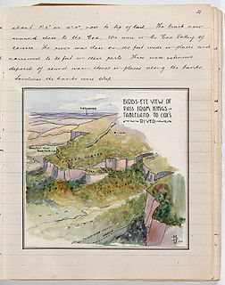
Myles Dunphy and Milo Dunphy were Australian conservationists who played an important role in creating the Australian wilderness movement.

Sydney is well endowed with open spaces and has many natural areas. Many of these exist even within the compact city centre. These include the Chinese Garden of Friendship and Hyde Park. The metropolitan area contains several national parks, including the Royal National Park, the second oldest national park in the world, which occupies an area of 132 square kilometres. Completing Sydney's wide array of green spaces, the leader is the Royal Botanical Gardens, with its large amount of green spaces, lush plants and colourful flowers.
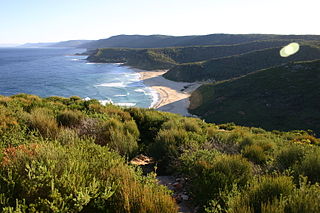
Garie Beach is a patrolled beach in the lower Royal National Park, on the outskirts of southern Sydney, Australia. The beach is one of eleven beaches located within the territory of the Royal National Park. It is also one of three patrolled beaches in the park, with the Garie Surf Life Saving Club patrolling the beach on weekends and Paid lifeguards from ALS Australian Lifeguard Services patrolling on weekdays during the summer school holidays.

The geography of Sydney is characterised by its coastal location on a basin bordered by the Pacific Ocean to the east, the Blue Mountains to the west, the Hawkesbury River to the north and the Woronora Plateau to the south. Sydney lies on a submergent coastline on the east coast of New South Wales, where the ocean level has risen to flood deep river valleys (rias) carved in the Sydney sandstone. Port Jackson, better known as Sydney Harbour, is one such ria.

Currawong Beach is a suburb in northern Sydney, in the state of New South Wales, Australia. Currawong Beach is 42 kilometres (26 mi) north of the Sydney central business district, in the local government area of Northern Beaches Council.

The Grose River, a perennial river that is part of the Hawkesbury-Nepean catchment, is located in the Blue Mountains region of New South Wales, Australia.

Mosman is an affluent suburb on the Lower North Shore region of Sydney, in the state of New South Wales, Australia. Mosman is located 8 kilometres north-east of the Sydney central business district and is the administrative centre for the local government area of the Municipality of Mosman.
The Garawarra State Conservation Area is a protected conservation area that is located on the southern suburban fringe of Greater Sydney, in the state of New South Wales, in eastern Australia. The 949-hectare (2,350-acre) reserve abuts the Royal National Park and is situated 40 kilometres (25 mi) south of the Sydney central business district, near Helensburgh. Garawarra was gazetted as a park in 1987, and added, together with the Royal National Park, to the Australian National Heritage List on 15 September 2006.
Lilyvale is a locality most of whose area is within the Royal National Park, south of Sydney, New South Wales, Australia. Helensburgh railway station was within the southern populated part of the locality. A Lilyvale railway station was open from 1890 until 1983.
Royal National Park Coastal Cabin Communities are heritage-listed cabin communities in the Royal National Park, Lilyvale, City of Wollongong, New South Wales, Australia. They were built from 1930 to 1950 by private citizens using their own initiative, resources and labour. It refers to the specific communities of Little Garie, Era and Burning Palms, also known collectively as the Royal National Park Coastal Shack Communities. The area is owned by the Office of Environment and Heritage. It was added to the New South Wales State Heritage Register on 27 April 2012.

The Caloola Club was a bushwalking and outdoors activity club that was based in Sydney, New South Wales, Australia, founded in 1945 and active until 1963, when it merged with the National Parks Association of N.S.W. The club was an influential part of the 'second wave' of the conservation and environmental movement in New South Wales during the post-WWII period.

