
Campbelltown is a suburb located on the outskirts of the metropolitan area of Sydney, New South Wales, Australia. It is located in Greater Western Sydney 53 kilometres (33 mi) south-west of the Sydney central business district by road. Campbelltown is the administrative seat of the local government area of the City of Campbelltown. It is also acknowledged on the register of the Geographical Names Board of New South Wales as one of only four cities within the Sydney metropolitan area.

Camperdown is an inner western suburb of Sydney, in the state of New South Wales, Australia. Camperdown is located 4 kilometres south-west of the Sydney central business district and is part of the Inner West region. Camperdown lies across the local government areas of the City of Sydney and Inner West Council.
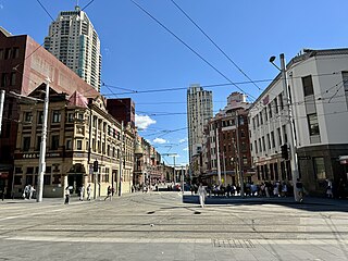
Haymarket is an inner city suburb of Sydney, New South Wales, Australia. It is located at the southern end of the Sydney central business district in the local government area of the City of Sydney. Haymarket includes much of Sydney's Chinatown, Thaitown and Railway Square localities. Haymarket is adjacent to Darling Harbour and is surrounded by the suburbs of Ultimo, Chippendale, Surry Hills and the Sydney CBD.

Surry Hills is an inner-east suburb of Sydney, in the state of New South Wales, Australia. Surry Hills is immediately south-east of the Sydney central business district in the local government area of the City of Sydney. Surry Hills is surrounded by the suburbs of Darlinghurst to the north, Chippendale and Haymarket to the west, Moore Park and Paddington to the east and Redfern to the south. It is often colloquially referred to as "Surry".

Bomaderry is a suburb in the City of Shoalhaven local government area in New South Wales, Australia. At the 2021 census, it had a population of 8,718 people. It is on the north shore of the Shoalhaven River, across the river from Nowra, the major town of the City of Shoalhaven, of which Bomaderry is locally regarded as being a suburb of the city.

Potts Point is a small and densely populated suburb in inner-city Sydney, New South Wales, Australia. Potts Point is located 2 kilometres (1.2 mi) east of the Sydney central business district and is part of the local government area of the City of Sydney.
Lilyfield is a suburb in the Inner West of Sydney, in the state of New South Wales, Australia. Lilyfield is located 6 kilometres west of the Sydney central business district, in the local government area of the Inner West Council.

Centennial Park is a suburb split between the local government area of the City of Sydney and the City of Randwick, located 4 kilometres (2.5 mi) east from the Sydney central business district, in the eastern suburbs of Sydney in the state of New South Wales, Australia.
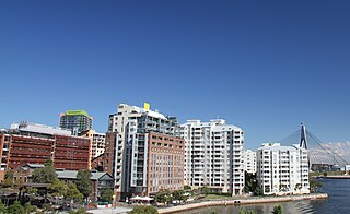
Pyrmont is an inner-city suburb of Sydney, in the state of New South Wales, Australia 2 kilometres south-west of the Sydney central business district in the local government area of the City of Sydney. It is also part of the Darling Harbour region. As of 2011, it is Australia's most densely populated suburb.

Double Bay is a harbourside eastern suburb of Sydney, in the state of New South Wales, Australia 4 kilometres east of the Sydney central business district. It is the administrative centre of the local government area of the Municipality of Woollahra.
Petersham is a suburb in the Inner West of Sydney, in the state of New South Wales, Australia. Petersham is located 6 kilometres south-west of the Sydney central business district, in the local government area of Inner West Council. Petersham is known for its extensive Portuguese commercial offerings, with many Portuguese businesses and restaurants, although only 156 (1.9%) of the population was actually born in Portugal.

Burwood is a suburb in the Inner West of Sydney, in the state of New South Wales, Australia. It is 10 kilometres (6.2 mi) west of the Sydney central business district and is the administrative centre for the local government area of Municipality of Burwood.

Cremorne is a suburb on the Lower North Shore of Sydney, New South Wales, Australia, located 6 kilometres north-east of the Sydney central business district, in the local government area of North Sydney Council.

Rozelle is a suburb in the inner west of Sydney, in the state of New South Wales, Australia. It is located 4 kilometres west of the Sydney central business district, in the local government area of the Inner West Council.

Woollahra is a suburb in the Eastern Suburbs of Sydney, in the state of New South Wales, Australia. Woollahra is located 5 kilometres east of the Sydney central business district, in the local government area of the Municipality of Woollahra. Woollahra is located on the traditional land of the Birrabirragal and Gadigal people of the Eora Nation. The Municipality of Woollahra takes its name from the suburb but its administrative centre is located in Double Bay. Woollahra is famous for its quiet, tree-lined residential streets and village-style shopping centre.

North Parramatta is a suburb on the North Shore of Sydney, in the state of New South Wales, Australia. North Parramatta is 24 kilometres north-west of the Sydney central business district in the local government area of the City of Parramatta.

Bonnyrigg is a suburb of Sydney, in the state of New South Wales, Australia 36 kilometres west of the Sydney central business district, in the local government area of the City of Fairfield. It is part of the Greater Western Sydney region.

Cattai is an historic suburb of Sydney, in the state of New South Wales, Australia. It is located 44 kilometres north-west of the Sydney central business district and 30 kilometres north-west of Parramatta. It is in the local government areas of The Hills Shire and City of Hawkesbury. Cattai's state electoral district is Hawkesbury, and its federal electoral divisions are Berowra and Macquarie.

Elizabeth Bay is a harbourside inner city suburb in the Eastern suburbs of Sydney, in the state of New South Wales, Australia. Elizabeth Bay is located three kilometres east of the Sydney central business district and is part of the local government area of the City of Sydney.

Sutton Forest is a small village in the Southern Highlands, New South Wales, Australia in Wingecarribee Shire. It is located 5 km southwest of Moss Vale on the Illawarra Highway. Sutton Forest was originally granted, then owned by Navy Chief officer, Captain John Nicholson who recently immigrated from Scotland to Australia. This privately owned estate was originally 700 acres, this is where John Nicholson lived and died.
