Ingleside is a suburb in Northern Sydney, in the state of New South Wales, Australia. Ingleside is located 28 kilometres north of the Sydney central business district, in the local government area of Northern Beaches Council. Ingleside is part of the Forest District region, about 2 kilometres from the coast at Mona Vale. Ingleside Heights and Tumbledown Dick are localities in the west of the suburb.

North Epping is a suburb of Sydney, in the state of New South Wales, Australia 19 kilometres north-west of the Sydney central business district in the local government area of Hornsby Shire. North Epping is in the Northern Sydney region, and is often referred to as part of the "North-West" or North Shore. Epping is a separate suburb to the south and under the Parramatta City Council, which shares the postcode of 2121.

Zetland is an inner southern suburb of Sydney, New South Wales, Australia 4 kilometres south of the Sydney central business district, in the local government area of the City of Sydney. The postcode is 2017.
Middle Cove is a suburb on the Lower North Shore of Sydney, in the state of New South Wales, Australia 9 kilometres north of the Sydney central business district, in the local government area of the City of Willoughby.
Blakehurst is a suburb in southern Sydney, in the state of New South Wales, Australia 18 kilometres south of the Sydney central business district, in the local government area of the Georges River Council. It is part of the St George area.

Hornsby Heights is a suburb of Northern Sydney, in the state of New South Wales, Australia. Hornsby Heights is located 26 kilometres north-west of the Sydney central business district, in the local government area of Hornsby Shire. The suburb is often referred to as part of the Upper North Shore.

Tuggerah is a large commercial hub and a suburb of the Central Coast region of New South Wales, Australia. Tuggerah is situated on the Main North Railway Line and Pacific Motorway, and is located approximately 91 km north of Sydney and 68 km south of Newcastle. It is the second largest business hub, major shopping area and financial district for the Central Coast after Erina.

Shelly Beach is a coastal suburb of the Central Coast region of New South Wales, Australia, located east of Tuggerah Lake and bordering the Pacific Ocean south of The Entrance. It is part of the Central Coast Council local government area. It is 66 km south of Newcastle & 93 km north of Sydney. Shelly Beach is considered one of the most popular surfing beaches on the Central Coast.

Box Head is a coastal locality in the Central Coast Council local government area located on the Central Coast of New South Wales, Australia. It is within Bouddi National Park which includes the island of Lion Island.
Calga is a suburb and locality of the Central Coast region of New South Wales, Australia, located 62 kilometres (39 mi) north of Sydney. It is part of the Central Coast Council local government area.

Killcare Heights is a south-eastern suburb and village located on the Bouddi Peninsula of the Central Coast region of New South Wales, Australia. It is part of the Central Coast Council local government area.
Little Wobby is a suburb of the Central Coast region of New South Wales, Australia, located on the north bank of the Hawkesbury River. It is part of the Central Coast Council local government area.
Marlow is a suburb of the Central Coast region of New South Wales, Australia on the north bank of the Hawkesbury River 58 kilometres (36 mi) north of Sydney. It is part of the Central Coast Council local government area.

Matcham is a semi-rural suburb of the Central Coast region of New South Wales, Australia. It is part of the Central Coast Council local government area and included in the electoral district of Terrigal. It has a hall and a historic church, St. George's Church, established in 1925.

Mooney Mooney is a small waterfront village and suburb of the Central Coast region of New South Wales, Australia. It is located in the Central Coast Council local government area at the end of a peninsula extending southwards into the Hawkesbury River, that is situated 50 kilometres (31 mi) north of Sydney. Mooney Mooney has two islands which are Peat Island and Spectacle Island.

Mooney Mooney Creek is a suburb of the Central Coast region of New South Wales, Australia, located 60 kilometres (37 mi) north of Sydney along both sides of the river after which it is named. It is part of the Central Coast Council local government area.
Point Clare is a suburb of the Central Coast region of New South Wales, Australia located approximately 75 kilometres (47 mi) north of Sydney and 4 kilometres (2 mi) south-west of Gosford's central business district on the western shore of Brisbane Water. It is part of the Central Coast Council local government area.
Somersby is a semi-rural locality of the Central Coast region of New South Wales, Australia, to the northwest of Gosford along the Pacific Highway. It is part of the Central Coast Council local government area.
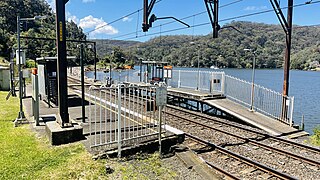
Wondabyne is a road-inaccessible locality located in the Central Coast region of New South Wales, Australia, and is part of the Central Coast Council local government area. The river that surrounds Wondabyne is called "Mullet Creek."

The Mooney Mooney Creek, a perennial river that is part of the Hawkesbury-Nepean catchment, is located in the Central Coast region of New South Wales, Australia.
