
Magnetic Island is an island 8 kilometres (5 mi) offshore from the city of Townsville, Queensland, Australia. This 52 km2 (20.1 sq mi) mountainous island in Cleveland Bay has effectively become a suburb of Townsville, with 2,335 permanent residents. The island is accessible from Townsville Breakwater to Nelly Bay Harbour by ferry. There is a large 39.5 km2 (15.3 sq mi) National Park and bird sanctuary and walking tracks can be taken between the populated bays and to a number of tourist destinations such as the World War II forts.

Dromana is a seaside suburb on the Mornington Peninsula in Melbourne, Victoria, Australia, 57 km (35 mi) south of Melbourne's Central Business District, located within the Shire of Mornington Peninsula local government area. Dromana recorded a population of 6,626 at the 2021 census.
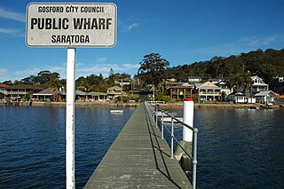
Saratoga is a residential south-eastern village and suburb of the Central Coast region of New South Wales, Australia, located on a peninsula of Brisbane Water and part of the Central Coast Council local government area. The suburb is characterised by its largely settled shoreline, with houses extending up coastal slopes to the base of the tall hills that comprise the core of the peninsula.

Towradgi is a small beach-side suburb approximately 5 km (3.1 mi) north of Wollongong, New South Wales, Australia. Towradgi is derived from the Dharawal word Kow-radgi, meaning "guardian of the sacred stones". On an early map it was called Towroger. Towradgi is served by electric trains at Towradgi railway station, opened in 1948.

Weipa is a coastal mining town in the local government area of Weipa Town in Queensland. It is one of the largest towns on the Cape York Peninsula. It exists because of the enormous bauxite deposits along the coast. The Port of Weipa is mainly involved in exports of bauxite. There are also shipments of live cattle from the port.
Ramsgate is a suburb in southern Sydney, in the state of New South Wales, Australia 16 km south of the Sydney central business district. It is part of the St George area. Divided by Rocky Point Road, part of Ramsgate to the east of Rocky Point Road is in the local government area of the Bayside Council, whilst properties to the west of Rocky Point Road are in the Georges River Council. Ramsgate Beach is a separate suburb, to the east.
Buff Point is a suburb of the Central Coast region of New South Wales, Australia. It is part of the Central Coast Council local government area.

Canton Beach is a suburb located on the Central Coast of New South Wales, Australia, as part of the Central Coast Council local government area. It is next to Toukley which is a large residential and holiday town.
Chittaway Point is a suburb of the Central Coast region of New South Wales, Australia. It is part of the Central Coast Council local government area.
Mannering Park is a suburb of the Central Coast region of New South Wales, Australia. It is part of the Central Coast Council local government area. It was formerly called Vales Point.
Summerland Point is a waterfront suburb that is located on the Central Coast of New South Wales, Australia. Summerland Point is situated on a peninsula extending northwards and facing towards Lake Macquarie. It is part of the Central Coast Council local government area. It was formerly known as Gwandalan West.
Bar Point is a suburb of the Central Coast region of New South Wales, Australia, located on the north bank of the Hawkesbury River 53 kilometres (33 mi) north of Sydney. It is part of the Central Coast Council local government area.
Cheero Point is a waterfront locality and suburb of the Central Coast region of New South Wales, Australia. Cheero Point is located on the west bank of the Mooney Mooney Creek in the Brisbane Water National Park. It is situated 53 kilometres (33 mi) north of Sydney. It is part of the Central Coast Council local government area.
Green Point is a south-eastern suburb of the Central Coast region of New South Wales, Australia between Erina and Kincumber accessed by a main road, Avoca Drive.Green Point has a natural border of Nunn's Creek between it and Erina.It is part of the Central Coast Council local government area.
Little Wobby is a suburb of the Central Coast region of New South Wales, Australia, located on the north bank of the Hawkesbury River. It is part of the Central Coast Council local government area.

Mooney Mooney is a small waterfront village and suburb of the Central Coast region of New South Wales, Australia. It is located in the Central Coast Council local government area at the end of a peninsula extending southwards into the Hawkesbury River, that is situated 50 kilometres (31 mi) north of Sydney. Mooney Mooney has two islands which are Peat Island and Spectacle Island.
Point Clare is a suburb of the Central Coast region of New South Wales, Australia located approximately 75 kilometres (47 mi) north of Sydney and 4 kilometres (2 mi) south-west of Gosford's central business district on the western shore of Brisbane Water. It is part of the Central Coast Council local government area.

Point Frederick is a suburb of the Central Coast region of New South Wales, Australia on a peninsula protruding into Brisbane Water 2 kilometres (1 mi) south-southeast of Gosford's central business district. It is part of the Central Coast Council local government area.

Wagstaffe is a south-eastern suburb of the Central Coast region of New South Wales, Australia on the Bouddi Peninsula. It is part of the Central Coast Council local government area. It was named after Captain Wagstaffe, one of the first settlers in the area. It has a general store, which is also the local post office. It is a thin slither of around 200 houses between the bay and the bush. Historically it was also known as Wagstaffe Point. In aboriginal dialect the point is called Kourang Gourang. A ferry service operates between Wagstaffe and Palm Beach. Travel time is 30 minutes.
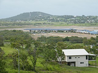
Zilzie is a coastal locality in the Livingstone Shire, Queensland, Australia. In the 2021 census, Zilzie had a population of 2,846 people.


