Pearl Beach, New South Wales

Last updated

Pearl Beach
Central Coast,  New South Wales
Pearlbeach01.JPG
Pearl Beach from Mount Ettalong, showing nearby Lion Island (New South Wales) and Pittwater in the distance
Pearl Beach, New South Wales
Population536 (2016 census) [1]
 • Density447/km2 (1,160/sq mi)
Postcode(s) 2256
Elevation9 m (30 ft)
Area1.2 km2 (0.5 sq mi)
Location
LGA(s) Central Coast Council
Parish Patonga
State electorate(s) Gosford
Federal division(s) Robertson
Suburbs around Pearl Beach:
Brisbane Water National Park Umina Beach Broken Bay
Brisbane Water National Park Pearl Beach Broken Bay
Patonga Hawkesbury River Lion Island

Pearl Beach is a suburb of Central Coast Council on the Central Coast of New South Wales, Australia. Pearl Beach was assigned 'suburb' status by the Geographical Names Board of NSW on 25 October 1991. [2]

Contents

History

Pearl Beach has a rich Indigenous history that is largely ignored by historical markers which have been erected in the community to commemorate visits by white settlers.

On 2 March 1788 Captain Arthur Phillip sailed north from Sydney Cove, Port Jackson, to the inlet described by Captain James Cook in 1770 as a "broken land" (id est Broken Bay). [3] As entered in their journals:

Geography

Located south of Umina Beach, being separated from it by a ridge upon which sits Mount Ettalong at a height of 56 metres (184 ft). It is bounded on the west and south by Brisbane Water National Park, and on the east by Broken Bay. Green Point, with Paul Landa Reserve, adjoins the southern end of the beach. The bay provides an example of a logarithmic spiral beach.

Population

In the 2016 Census, there were 536 people in Pearl Beach. 68.7% of people were born in Australia and 88.2% of people spoke only English at home. The most common responses for religion were No Religion 37.1% and Anglican 20.4%. [1]

Swimming

The south end of the beach is placid, sheltered by a rocky point and Lion Island and is favoured by most visitors as a swimming spot. The north end of the beach is known for rough surf and is unofficially called "the dumpers". [5] The dumpers, excluding the roughest waves at the far north end of the beach, are a popular bodysurfing spot for strong, confident swimmers, except during particularly rough surf or at king tide. Swimmers risk getting violently pounded onto the sand by a wave, or "chundered" (usually kayaking terminology) by waves dumping into a deep trench along the shoreline, but can generally avoid getting chundered by moving towards dry land or ducking under the break of the wave and swimming back to shore in smaller waves.

In 2014, five-year-old Chayce Kofe drowned after he was swept off the shore by a large wave. [6] Gosford City Council continues to oppose danger signs despite calls from the local Member Kathy Smith to erect them. [7]

See also

Rip current

Environment

Pearl Beach village is located within the National Trust of Australia's Broken Bay Entrance Landscape Conservation Area. [8]

Awards

Community groups

The Pearl Beach Progress Association was established in 1929 and grew out of informal gatherings of residents to discuss local problems and community projects. Today the Pearl Beach Progress Association promotes the best interests of the village, protects and enhances our wonderful natural environment and manages the historic Memorial Community Hall. [11] Membership is available to anyone who is 16 years of age or older and lives in Pearl Beach or are owners of property in Pearl Beach, and the immediate families of such persons. [12]

A volunteer firefighting brigade under the NSW Rural Fire Service, formed in 1953. The Station is located at 39 Emerald Avenue.

Community events

Since 2006, Opera in the Arboretum has been performed annually in March in the Crommelin Native Arboretum. The event is organised by the Rotary Club of Woy Woy and features performances by leading Australian opera identities. All proceeds are given to charities and Rotary projects. [13]

Residential development

Residential development in Pearl Beach is governed by Gosford City Council's Development Control Plan 162 (DCP16). The aim of the Control Plan is to preserve, improve and restore the special natural character of Pearl Beach. It applies to all properties in the village of Pearl Beach, including, proposed buildings and major alterations and additions to existing buildings. DCP16 has superseded Gosford City Council's policies for Pearl Beach titled DO 16 and Pearl Beach Residential Development Policy. [14]

Infrastructure

Road

Pearl Beach Drive is the only vehicular access road to the town.

There is pedestrian access is via the former Pearl Beach Road, also sometimes referred to as Cliff Road, [15] which, nowadays, is a rocky unstable walking track that runs 30 feet above the shoreline around the base of the Mount Ettalong cliff via Umina Point. Pearl Beach Road is Heritage Listed, notably as a Section 2: Items listed by Local Government and State agencies. [16]

Vehicular access to Pearl Beach has been problematic ever since motorised traffic was given access to the town, some events in this long saga include:

Rock Pool

In 1926 construction of the Rock Pool, located at the southern end of the beach, adjoining Green Point, commenced. Once completed in 1928, C. R. Staples and Co. used it in promotional material to help sell land. Up until 1950, the pool suffered a pollution problem from its own amenities block that used open uncovered sanitary pans. Design and maintenance problems have plague the pool from the start. [23] Nonetheless, many people have and still enjoy the rock pool. During 2010, the rock pool was closed for 4 months whilst major renovations were carried out. [24] [25]

Electricity

Plans to provide Pearl Beach with electricity were given an approval on 31 December 1936. Mr. R. Franki, consulting electrical engineer to the Woy Woy Council, was instructed to proceed with construction after the necessary number of guarantees had been signed by the residents. [26]

Sports facilities

Two tennis courts and a narrow artificial turf bowling green are located in Opal Close, bookings required. [27] Lap swimming is available at the rock pool located at the southern end of the beach. [28]

Notable residents

Related Research Articles

<span class="mw-page-title-main">Gosford</span> City in New South Wales, Australia

Gosford is a waterfront city at the northern end of Brisbane Water on the Central Coast in the state of New South Wales, Australia. The Gosford waterfront is known for its boating and scenic views on the shores of Brisbane Water. Gosford is the main commercial hub and gateway of the Central Coast. It is situated approximately 77 km (48 mi) north of Sydney and 86 km (53 mi) south of Newcastle. Gosford is located in the local government area of the Central Coast Council.

<span class="mw-page-title-main">Central Coast (New South Wales)</span> Region in New South Wales, Australia

The Central Coast is a peri-urban region lying on the Pacific Ocean in northern-eastern New South Wales, Australia. The region is situated north of Sydney, which is filled with subtropical national parks, forests and also encompasses the major coastal waterways of Brisbane Water, Tuggerah Lakes and southern Lake Macquarie. The region's hinterland, which has fertile valleys, rural farmland and wineries, and also includes the Watagan Mountains. The Central Coast is known for its regional coastal towns like Terrigal, The Entrance, Ettalong Beach, Budgewoi and Bateau Bay with resorts and holiday parks, which feature many expansive beaches and lagoons with surfing and coastal tracks, as well as scenic views. Gosford is the main commercial hub and gateway.

<span class="mw-page-title-main">Brisbane Water</span> River in New South Wales, Australia

Brisbane Water is a wave-dominated barrier estuary located in the Central Coast region of New South Wales, Australia. Brisbane Water has its origin at the confluence of the Narara and Coorumbine Creeks, to the south–east of Gosford and travels for approximately 18 kilometres (11 mi) in a southerly direction to its mouth at Broken Bay, about 7 kilometres (4.3 mi) from the Tasman Sea, at Barrenjoey Head. A number of towns and suburbs surround the shores of Brisbane Water, including Blackwall, Booker Bay, Davistown, Empire Bay, Erina, Ettalong Beach, Gosford, Green Point, Hardys Bay, Kilcare, Kincumber, Koolewong, Phegans Bay, Point Frederick, Point Clare, Saratoga, Tascott, Wagstaffe, and Woy Woy. Contained within Brisbane Water is St Huberts Island, Rileys Island, Dunmar Island and Pelican Island; and adjoining the estuary is Brisbane Water National Park to the west and Bouddi National Park to the east. Forming part of the same tidal estuary system is a separate but connected basin, the Kincumber Broadwater, lying to the east of Davistown.

<span class="mw-page-title-main">City of Gosford</span> Former local government area in New South Wales, Australia

The City of Gosford was a local government area that was located in the Central Coast region in the state of New South Wales, Australia. The incorporation of Gosford dates back to 1886 when the Town of Gosford was proclaimed as the Borough of Gosford, becoming the Municipality of Gosford from 1906. In 1908, the Gosford Municipality merged into Erina Shire which covered the remaining Central Coast area outside of Gosford, but regained its independence in 1936. From 1 January 1947, local government in the Central Coast region was reorganised, creating Gosford Shire and Wyong Shire, and the final boundaries of Gosford City Council date from this period. From 1 January 1980, Gosford Shire was granted city status, becoming the City of Gosford. On 12 May 2016 the Minister for Local Government amalgamated the City of Gosford and Wyong Shire Councils. The Central Coast Council was established on the same day, covering the combined areas.

<span class="mw-page-title-main">Wyong Shire</span> Former local government area in New South Wales, Australia

Wyong Shire was a local government area located in the Central Coast region of New South Wales, Australia. The incorporation of the Wyong area dates back to 7 March 1906 when the entire area of the Brisbane Water Police District outside of the Town of Gosford was proclaimed as the Erina Shire. From 1 January 1947, local government in the Central Coast region was reorganised, creating Gosford Shire and Wyong Shire, which comprised Erina Shire north and east of Kulnura, Central Mangrove and Lisarow.

<span class="mw-page-title-main">Woy Woy railway station</span> Australian railway station

Woy Woy railway station is located on the Main Northern line in New South Wales, Australia. It serves the southern Central Coast town of Woy Woy opening on 1 February 1889.

<span class="mw-page-title-main">Woy Woy</span> Town in New South Wales, Australia

Woy Woy is a coastal town in the Central Coast region of the New South Wales state of Australia. The town is located on the southern reaches of Brisbane Water and near the mouth of Brisbane Water at the Pacific Ocean, it is a popular holiday destination. Woy Woy is located 84 km (52 mi) north of the state capital Sydney. It is a population centre within the Central Coast Council local government area.

<span class="mw-page-title-main">Umina Beach, New South Wales</span> Suburb of Central Coast, New South Wales, Australia

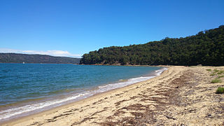
Umina Beach is a suburb within the Central Coast Council local government area on the Central Coast of New South Wales, Australia. Umina Beach is situated 85 kilometres (53 mi) north of Sydney and 111 kilometres (69 mi) south of Newcastle.

<span class="mw-page-title-main">Gosford railway station</span> Australian railway station

Gosford railway station is located on the Main Northern line in New South Wales, Australia. It serves the Central Coast city of Gosford, opening on 15 August 1887.

Gosford is an electoral district of the New South Wales Legislative Assembly in Australia. The electorate covers the southern and western parts of the Central Coast Council in the Central Coast region, including central Gosford and Woy Woy.

<span class="mw-page-title-main">Ettalong Beach</span> Suburb of Central Coast, New South Wales, Australia

Ettalong Beach is a suburb of the Central Coast region of New South Wales, Australia south of Woy Woy on Brisbane Water at the point where it meets Broken Bay, about 86 km north of Sydney. It is part of the Central Coast Council local government area. Ettalong Beach is the natural eastward continuation of Umina Beach and Ocean Beach. The village is serviced by a small retail centre along Ocean View Road.

<span class="mw-page-title-main">Patonga, New South Wales</span> Suburb of Central Coast, New South Wales, Australia

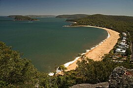
Patonga is a small beach side fishing and holiday village which is part of the Central Coast region of New South Wales, Australia, located on the edge of Brisk Bay and near the mouth of the Hawkesbury River. It is part of the Central Coast Council local government area. Patonga is the southern most village of the Central Coast.

<span class="mw-page-title-main">Tascott, New South Wales</span> Suburb of Central Coast, New South Wales, Australia

Tascott is a suburb of the Central Coast region of New South Wales, Australia between Gosford and Woy Woy on Brisbane Water's western shore. It is part of the Central Coast Council local government area.

Central Coast Ferries is an Australian ferry operator on the Central Coast of New South Wales.

<span class="mw-page-title-main">1994 eastern seaboard fires</span>

The 1994 eastern seaboard fires were significant Australian bushfires that occurred in New South Wales, Australia during the bushfire season of 1993–1994. Some 20,000 firefighters were deployed against some 800 fires throughout the state, and along the coast and ranges from Batemans Bay in the south to the Queensland border in the north, including populated areas of the city of Sydney, the Blue Mountains and the Central Coast. The fires caused mass evacuations of many thousands of people, claimed four lives, destroyed some 225 homes and burned out 800,000 hectares of bushland. The firefighting effort raised in response was one of the largest seen in Australian history.

<span class="mw-page-title-main">Erina Shire</span> Former local government area in New South Wales, Australia

The Shire of Erina was a local government area covering the majority of the Central Coast region of New South Wales, Australia. The shire was proclaimed on 7 March 1906 as a result of the passing of the Local Government (Shires) Act 1905 and covered most of the Central Coast region with the exception of the Town of Gosford, which had been incorporated in 1886.

<span class="mw-page-title-main">Woy Woy Tunnel</span> Railway tunnel in New South Wales, Australia

The Woy Woy railway tunnel is a heritage-listed railway tunnel located between Wondabyne and Woy Woy stations on the Main Northern railway line in New South Wales, Australia. The dual-track 1.69-kilometre tunnel was opened on 16 January 1888. It was added to the New South Wales State Heritage Register on 28 June 2013.

<span class="mw-page-title-main">Central Coast Council (New South Wales)</span> Local government area in New South Wales, Australia

The Central Coast Council is a local government area in the Central Coast region of New South Wales, Australia. It is adjacent to the Pacific Highway, Central Coast Highway, the Northern railway line and the Pacific Ocean. The council was formed on 12 May 2016 following the merger of the Gosford City and Wyong Shire Councils.

The Shire of Woy Woy was a local government area on the Central Coast region of New South Wales, Australia, centred on the town of Woy Woy. The shire was proclaimed on 1 August 1928 as a result of the proclamation of the separation of the D Riding of Erina Shire and had its council seat at Woy Woy, but covered the majority of the Woy Woy peninsula including Woy Woy Bay, Umina, Blackwall, Kariong, Pearl Beach, and Patonga. Woy Woy Shire was abolished on 1 January 1947 with the reorganisation of local government in the Central Coast region following the end of the Second World War, with the council area amalgamated into Gosford Shire.

References

  1. 1 2 Australian Bureau of Statistics (27 June 2017). "Pearl Beach (State Suburb)". 2016 Census QuickStats. Retrieved 11 April 2020. OOjs UI icon edit-ltr-progressive.svg CC-BY icon.svg Material was copied from this source, which is available under a Creative Commons Attribution 4.0 International License.
  2. "Pearl Beach". Geographical Names Register (GNR) of NSW. Geographical Names Board of New South Wales . Retrieved 7 August 2013. OOjs UI icon edit-ltr-progressive.svg
  3. Pittwater Council Library, Pittwater's Past. Retrieved 7 November 2010
  4. This Isn't Sydney Blog: Photographs on Pearl Beach Bicentennial Plagues. Retrieved 7 November 2010
  5. The Gem (PDF), PearlBeach Progress Association, March 2012, p. 2, retrieved 12 July 2014
  6. "'It's all too real now'". Daily Telegraph. 21 July 2014.
  7. Barnes, Denice (16 July 2015). "Drowning death prompts calls for signage at 'dangerous' beach". Daily Telegraph.
  8. Gosford City Council Development Control Plan Index, DCP 162 - Residential Development (Pearl Beach). Retrieved 9 December 2010
  9. Peninsula Community Access News Pearl Beach wins clean beach award, issue 228, 16 November 2009. Retrieved 7 November 2010
  10. Keep Australia Beautiful NSW Pearl Beach Becomes National Finalist, media release dated 9 December 2010. Retrieved 23 December 2010
  11. Pearl Beach Progress Association | History. Retrieved 8 September 2020
  12. Pearl Beach Progress Association | Membership. Retrieved 8 September 2020
  13. Pearl Beach Opera in the Arboretum History. Retrieved 7 November 2010
  14. Gosford City Council Development Control Plan Index, DCP 162 - Residential Development (Pearl Beach). Retrieved 8 December 2010
  15. Central Coast Express Advocate Pearl Beach cliff walk abandoned over lack of funds, 4 August 2010. Retrieved 7 November 2010
  16. NSW Government Heritage Branch, Pearl Beach Road. Retrieved 7 December 2010
  17. Gosford City Council Local History Pearl Beach Real Estate Prospectus Circa 1926. Retrieved 7 November 2010
  18. The Sydney Morning Herald, Pearl Beach Road, Friday 20 December 1935. Retrieved 7 November 2010
  19. The Sydney Morning Herald, Objections to Road, Thursday 11 June 1936. Retrieved 7 November 2010
  20. The Sydney Morning Herald, Pearl Beach Wants Wharf, Wednesday 6 April 1938. Retrieved 7 November 2010
  21. The Sydney Morning Herald, Pearl Beach Road, Monday 19 June 1939. Retrieved 7 November 2010
  22. Gosford City Council Media Release Roadwork Update, 04-08-2010 12:00 AM. Retrieved 7 November 2010
  23. New south wales Ocean Baths, Pearl Beach Rock Pool. Retrieved 7 December 2010
  24. Central Coast express advocate, New Pearl Beach Pool a Triumph for Community, 5 December 2010. Retrieved 7 December 2010
  25. NBN TV, Pearl Beach Icon Restored, 28 November 2010 (23 December 2010)
  26. The Sydney Morning Herald, Pearl Beach Electricity, 31 December 1936. Retrieved 7 December 2010
  27. Gosford City Tennis Courts Archived 19 August 2010 at the Wayback Machine . Retrieved 23 December 2010
  28. Gosford City Aquatic Facilities, Ocean Rock Pools. Retrieved 23 December 2010

33°32′31″S151°18′29″E / 33.542°S 151.308°E / -33.542; 151.308