Liverpool is a suburb of Greater Western Sydney, in the state of New South Wales, Australia. It is located approximately 31 kilometres (19 mi) south-west of the Sydney CBD. Liverpool is the administrative seat of the local government area of the City of Liverpool and is situated in the Cumberland Plain.

The Hume Highway, inclusive of the sections now known as the Hume Freeway and Hume Motorway, is one of Australia's major inter-city national highways, running for 840 kilometres (520 mi) between Melbourne in the southwest and Sydney in the northeast. Upgrading of the route from Sydney's outskirts to Melbourne's outskirts to dual carriageway was completed on 7 August 2013.

The Georges River, also known as Tucoerah River, is an intermediate tide-dominated drowned valley estuary, located to the south and west of Sydney, New South Wales, Australia.
Greater Western Sydney (GWS) is a large region of the metropolitan area of Greater Sydney, New South Wales (NSW), Australia that generally embraces the north-west, south-west, central-west, and far western sub-regions within Sydney's metropolitan area and encompasses 13 local government areas: Blacktown, Blue Mountains, Camden, Campbelltown, Canterbury-Bankstown, Cumberland, Fairfield, Hawkesbury, Hills Shire, Liverpool, Parramatta, Penrith and Wollondilly. It includes Western Sydney, which has a number of different definitions, although the one consistently used is the region composed of ten local government authorities, most of which are members of the Western Sydney Regional Organisation of Councils (WSROC). Penrith, Hills Shire & Canterbury-Bankstown are not WSROC members. The NSW Government's Office of Western Sydney calls the region "Greater Western Sydney".

The Clyde River is an open intermediate tide dominated drowned valley estuary, or perennial river that flows into the Tasman Sea at Batemans Bay, located in the South Coast region of New South Wales, Australia.

Warwick Farm railway station is located on the Main South line, serving the Sydney suburb of Warwick Farm. It is served by Sydney Trains T2 Inner West & Leppington, T3 Bankstown and T5 Cumberland line services.

Liverpool railway station is a heritage-listed railway station located on the Main South line, serving the Sydney suburb of Liverpool in Australia. It is served by Sydney Trains T2 Inner West & Leppington, T3 Bankstown and T5 Cumberland services. It was added to the New South Wales State Heritage Register on 2 April 1999.

Warwick Farm is a suburb of Sydney, in the state of New South Wales, Australia. Warwick Farm is located 30 kilometres west of the Sydney central business district, in the local government area of the City of Liverpool and is part of the South-western Sydney region.
Rossmore is a suburb of Sydney, in the state of New South Wales, Australia.
Mount Pritchard is a suburb of Sydney, in the state of New South Wales, Australia 34 kilometres south-west of the Sydney central business district, in the local government areas of the City of Fairfield and the City of Liverpool, and is part of the South-western Sydney region.

Bonnyrigg is a suburb of Sydney, in the state of New South Wales, Australia 36 kilometres west of the Sydney central business district, in the local government area of the City of Fairfield. It is part of the Greater Western Sydney region.
Bringelly is a suburb of Sydney, in the state of New South Wales, Australia. It is located on the Northern Road between Penrith and Camden. It has a public school. Bringelly is also the name of a local hill.

Cartwright is a suburb in south-western Sydney, in the state of New South Wales, Australia 38 kilometres south-west of the Sydney central business district, in the local government area of the City of Liverpool.
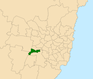
Liverpool is an electoral district of the Legislative Assembly of the Australian state of New South Wales in Sydney's West. It is currently represented by Paul Lynch of the Labor Party.

Prospect Creek, an urban watercourse of the Georges River catchment, is located in the western and Canterbury-Bankstown regions of Sydney, in New South Wales, Australia.

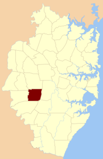
St Luke Parish is one of the 57 parishes of Cumberland County, New South Wales, a cadastral unit for use on land titles. It is bounded by Prospect Creek in the north-east, Georges River in the south-east, and Cowpasture Road in the west. It was named after the Anglican church of St Lukes in Liverpool, which was completed in 1819. The parish is mentioned in various legislation dealing with property law for the city of Liverpool.

Haslams Creek, a southern tributary of the Parramatta River, is a creek west of Sydney Harbour, located in Sydney, Australia. It flows through Sydney Olympic Park and joins Parramatta River at Homebush Bay. In 1793, the first grants were made to free settlers, with Samuel Haslam receiving his first grant in 1806. A 50 acre grant north of Parramatta Road, the first grant, was followed by a second small grant south of Parramatta Road and east of Haslams Creek. Haslams Creek flowed through the holdings of the Sydney Meat Preserving Company Ltd 1876-1965, which at one point damned the creek. When opened, Lidcombe railway station actually bore the name Haslams Creek Station
Pambula River is an open semi-mature wave dominated barrier estuary or perennial river located in the South Coast region of New South Wales, Australia.
The Parish of Cabramatta is a civil parish of Cumberland County, a Cadastral division of New South Wales.
The Lennox River is the proposed name for a waterway located in Sydney's South-Western Suburbs. The existing waterway is the tidal reach of Prospect Creek, a tributary of the Georges River. A proposal has been made to upgrade and reclassify the waterway as a 'river'. The proposed river would be 6.5 kilometres (4 mi) long, starting at the confluence of Orphan School Creek and Prospect Creek at Fairfield and flowing to the Georges River emptying into Dhurawal Bay at Garrison Point.
