Port Jackson, commonly known as Sydney Harbour, consists of the waters of Sydney Harbour, Middle Harbour, North Harbour and the Lane Cove and Parramatta Rivers, is the ria or natural harbour of Sydney, New South Wales, Australia. The harbour is an inlet of the Tasman Sea. It is the location of the Sydney Opera House and Sydney Harbour Bridge. The location of the first European settlement and colony on the Australian mainland, Port Jackson has continued to play a key role in the history and development of Sydney.

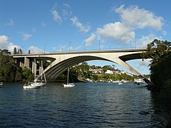
Gladesville Bridge is a heritage-listed concrete arch road bridge that carries Victoria Road over the Parramatta River, linking the Sydney suburbs of Huntleys Point and Drummoyne, in the local government areas of Canada Bay and Hunter's Hill, in New South Wales, Australia. Despite its name, the bridge is not in Gladesville.
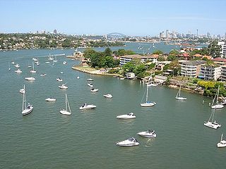
The Parramatta River is an intermediate tide-dominated, drowned valley estuary located in Sydney, New South Wales, Australia. With an average depth of 5.1 metres (17 ft), the Parramatta River is the main tributary of Sydney Harbour, a branch of Port Jackson. Secondary tributaries include the smaller Lane Cove and Duck rivers.

Hunters Hill is a suburb of Northern Sydney, in the state of New South Wales, Australia. Hunters Hill is located 9 kilometres (5.6 mi) north-west of the Sydney central business district and is the administrative centre for the local government area of the Municipality of Hunter's Hill.
In Australia, Lower North Shore refers to the northern suburbs of Sydney adjoining Sydney Harbour. The three bodies of water that surround the Lower North Shore are Lane Cove River on its western border, Sydney Harbour on its south side, and Middle Harbour on its east. The Lower North Shore borders the Upper North Shore when the Lane Cover River and Middle Harbour are at their closest.

Gladesville is a suburb in the Lower North Shore of Sydney, in the state of New South Wales, Australia. Gladesville is located 10 kilometres north-west of the Sydney central business district, in the local government area of the City of Ryde and the Municipality of Hunter's Hill. Gladesville is part of the federal electorates of North Sydney and Bennelong.

The Municipality of Hunter's Hill or Hunter's Hill Council is a local government area on the Lower North Shore of Sydney, in the state of New South Wales, Australia. The municipality was first proclaimed in 1861, which includes the suburbs of Hunters Hill, Woolwich, Huntleys Point, Tarban, Henley and part of Gladesville. As at the 2021 census, the Municipality had an estimated population of 13,559. At 5.7 square kilometres (2.2 sq mi), the Municipality is, by area, the smallest local government area in New South Wales and its boundaries remain mostly unaltered since its establishment in 1861. The mayor of Hunters Hill since 4 December 2021 is Clr. Zac Miles.

Henley is a suburb on the Lower North Shore of Sydney, in the state of New South Wales, Australia. Henley is located 9 kilometres west of the Sydney central business district, in the local government area of the Municipality of Hunter's Hill. Henley sits on the northern side of the Parramatta River.

Huntleys Point is a suburb in the Northern Suburbs district of Sydney, in the state of New South Wales, Australia. Huntleys Point is located nine kilometres north-west of the Sydney central business district, in the local government area of the Municipality of Hunter's Hill. Huntleys Point sits on the northern shore of the Parramatta River. It was named after Alfred Reynolds Huntley, who purchased the land now covered by the suburb and built Point House in 1851. He had arrived in the colony with his family in 1836.

The Tarban Creek Bridge is a prestressed concrete arch bridge that carries the Burns Bay Road across the Tarban Creek, located west of the Sydney central business district in New South Wales, Australia. The bridge is situated between the Gladesville Bridge and the Fig Tree Bridge, being immediately to the north of Gladesville Bridge. The bridge connects the suburbs of Hunters Hill and Huntleys Point. In addition to the four-lane carriage, the bridge carries a grade-separated shared pedestrian footpath and cycleway.

The Fig Tree Bridge is a road bridge that carries Burns Bay Road across the Lane Cove River, and connects the suburbs of Hunters Hill in the south and Linley Point in the north, located approximately seven kilometres northwest of the central business district of Sydney in New South Wales, Australia. The concrete girder bridge carries motor vehicles, and a grade-separated footpath and cycleway.
The North Western Expressway and the Lane Cove Valley Expressway was a planned but later cancelled freeway route in Sydney, New South Wales, Australia, intended to link the Sydney central business district to its north-western suburbs, and ultimately the Sydney–Newcastle Freeway to Newcastle. The entirety of the Sydney to Newcastle route was to be known as the F3 Freeway, a name that remains as a common name of the Sydney–Newcastle Freeway.

Huntleys Cove is a suburb on the Lower North Shore of Sydney, in the state of New South Wales, Australia. Huntleys Cove is located 9 kilometres north-west of the Sydney central business district, in the local government area of the Municipality of Hunter's Hill. Huntleys Cove sits on the peninsula between Tarban Creek and the Parramatta River.

Iron Cove Creek, a southern tributary of the Parramatta River, is an urban stream west of Sydney Harbour, located in the inner-western Sydney suburbs of Croydon, Ashfield, Haberfield and Five Dock in New South Wales, Australia.

Northern Sydney is a large metropolitan area in Greater Sydney, New South Wales, Australia on the north shore of Sydney Harbour and Parramatta River. The region embraces suburbs in Sydney's north-east, north and inner north west. Northern Sydney is divided into distinctive regions such as the North Shore, Northern Beaches and Forest District.

Victoria Road is a major road in Sydney, New South Wales, Australia, connecting Parramatta with Rozelle and is currently one of the longest roads in Sydney. The road passes over two major bridges: the Iron Cove Bridge over Iron Cove, and the Gladesville Bridge over the Parramatta River.

The Gladesville Mental Hospital, formerly known as the Tarban Creek Lunatic Asylum, was a psychiatric hospital established in 1838 in the Sydney suburb of Gladesville. The hospital officially closed in 1993, with the last inpatient services ceasing in 1997.
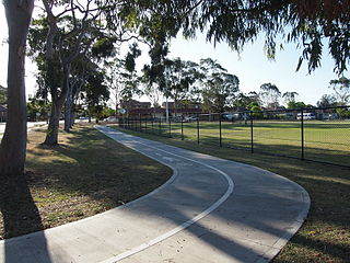
Bike paths in Sydney, New South Wales, Australia, vary widely, with the majority either shared cycle and pedestrian paths or on road paths, and a small number of separated cycleways. In 2009 the Sydney Morning Herald reported that "Sydney's cycleways are not so much an organised network as a fragmented collection of winding paths and half-finished ideas. Most were built or designed when cycling was viewed as a pleasant pastime rather than a practical form of travel and are now poorly suited to commuting."
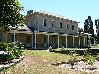
The Priory is a heritage-listed former farm, mental health facility, convent and homestead and now building, vacant building and proposed community arts uses at Manning Road, Gladesville in the Municipality of Hunter's Hill local government area of New South Wales, Australia. The main part of The Priory was designed by William Weaver and Henry Hardie Kemp, and built from 1847 to 1874 by Thomas Stubbs, The Marist Fathers in Australia, and Thomas Salter. It is also known as Gladesville Hospital, Gladesville Asylum and The Priory and curtilage. It was added to the New South Wales State Heritage Register on 3 December 2004.