Watsons Bay

Last updated

Watsons Bay
Sydney,  New South Wales
Watsons Bay - Camp Cove Beach, Sydney - Nov 2008.jpg
Camp Cove beach in Watsons Bay
Watsons Bay
Population883 (SAL 2021) [1]
Established1801
Postcode(s) 2030
Elevation6 m (20 ft)
Area0.6 km2 (0.2 sq mi)
Location11 km (7 mi) north-east of Sydney CBD
LGA(s) Municipality of Woollahra
State electorate(s) Vaucluse
Federal division(s) Wentworth
Suburbs around Watsons Bay:
Clifton Gardens Manly Tasman Sea
Mosman Watsons Bay Tasman Sea
Vaucluse Vaucluse Tasman Sea
View of (The Gap), Watsons Bay, looking north WatsonsBay0131.JPG
View of (The Gap), Watsons Bay, looking north

Watsons Bay is a harbourside, eastern suburb of Sydney, in the state of New South Wales, Australia. Watsons Bay is located 11 km north-east of the Sydney central business district, in the local government area of the Municipality of Woollahra.

Contents

Watsons Bay sits on the end of the South Head peninsula and takes its name from the sheltered bay and anchorage on its western side, in Port Jackson (Sydney Harbour). It provides views across the harbour to the Sydney Harbour Bridge. The Gap is an ocean cliff on the eastern side with views to Manly at North Head and the Pacific Ocean. Vaucluse is the only adjacent suburb, to the south.

History

Aboriginal history

The original inhabitants of the area that is now known as Watsons Bay, were the Cadigal people. The Cadigal referred to the area as Kutti. This indigenous group of people fished and collected shellfish in the waters and bays off South Head. They acquired their resources from Camp Cove and carved rock engravings there, which have since eroded from the cliff faces and rock surfaces that line the coastline. [2]

European settlement

The first Europeans arrived at the location on 21 January 1788 as the First Fleet landed and stayed overnight on Camp Cove. [3] A lookout was later built on the cliffs in 1790. [3] The first grant of 20 acres (81,000 m2) was made to Edward Laing in 1793 in the Camp Cove Area. Early homes were built for government and military officials working at the local installations. [3]

Watson's Bay was named after Robert Watson (1756–1819), formerly of HMS Sirius, when he had to beach his three vessels at Camp Cove for many years because of their being potentially sold by the Provost Marshal. [4] Watson was appointed harbour pilot and harbourmaster of the port of Sydney in 1811 and the first superintendent of Macquarie Lighthouse in 1816. [5]

Watsons Bay remained an isolated fishing village until development began in the 1860s. [6] The population grew from three dozen in 1828 to 122 in 1841. [3] Subdivision started in the 1850s. [6] After a ferry service opened in the 1870's, a number of hotels were opened. [6]

Today, The Gap is known as a notorious suicide spot. [7]

Dunbar

The Dunbar was wrecked near the entrance to Sydney Harbour, Australia in 1857 with the loss of 121 lives. The wreck of the Dunbar ranks as one of Australia's worst maritime disasters, with the event still retained in the social history of Sydney and NSW. [8] The Dunbar had mistaken the bay of The Gap for the harbour entrance. This led to the construction of the Hornby Lighthouse. In 1910, at Jacob’s Ladder, the anchor from the ship was recovered along with other relics and were placed in a museum behind the old Town Hall in Military Road by Vaucluse Council. The anchor was transferred to the cliffs of Gap Park by Ald. Coombes and a memorial was unveiled in August 1930. [9]

Trams

Former tram terminus, Gap Park, c1949 Watsons bay tram cutting gap park.jpg
Former tram terminus, Gap Park, c1949

The City to Watson's Bay tram line was extended from Edgecliff to Signal Hill Station, Watson's Bay in 1903 with further extensions to Gap Park in 1909. The latter extension included a new tram terminus adjacent to The Gap and a tram cutting cut into the rock face in Gap Park that ran above and parallel to Gap Road that gradually descended to street level before terminating. [10]

The line from the city commenced with a loop at the corner of Erskine and Day Streets near Wynyard station. It then proceeded south down Day Street before turning left into King Street passing through Queen's Square at St James station. It then made a right hand turn into College Street, and headed south before turning left into Boomerang Street. The line then continued left into William Street, through King's Cross and then along Bayswater Road and into New South Head Road at Rushcutters Bay. The line then followed the course of New and Old South Head Roads before turning right into Gap Park. After turning right into Gap Park a single track passed through narrow rock cuttings, low cliffs and rugged back-drops, turning its way down to the terminus at Watsons Bay.

The line had its own depot and city terminus and operated independently, although it was connected to the main Sydney tram network. In 1949, the line from Rose Bay to Watson's Bay closed, but reopened in 1950 due to public protest. In 1950, the line down King Street to Erskine Street closed and a new terminus constructed at Queens Square. The remainder of the line closed in 1960, the tracks were removed and in 1964 the Council re-vegetated the area around the former tramway cutting in gap park with the object of restoring the area.

When walking up the steps to The Gap at Watsons Bay, there is flat ground in between two sets of steps. This continues for a fair way in both directions, and is the old tram right of way.

The present-day Transdev John Holland route 324 follows the route of the former tram line as far as the point where the tramway turned off Old South Head Road into Gap Park. The bus and tram routes meet again near the terminus in Military Road. [11]

Sydney Harbour defences during WWII


In 1942, during World War II, the Sydney Harbour anti-submarine boom net was constructed on Georges Head to prevent enemy submarines from entering Sydney Harbour. The boom net spanned the entire width of Port Jackson and a boom net winch house was located on Liangs Point, Watsons Bay.

On the night of 31 May 1942, three Japanese midget submarines attempted to enter Sydney Harbour in what became known as the attack on Sydney Harbour. [12] [13] One of the Japanese midget submarines became entangled in the boom net; and, after unsuccessful attempts to free the submarine, the crew detonated charges within the sub, killing themselves and destroying their sub in the process. [14]

During this period, Nielsen Park was used as an anti-aircraft base. The base had its own interim wooden barracks, searchlights and anti-aircraft guns. [15]

In Gap Park, a gun emplacement for a small calibre gun, which was never installed was also intended for use during World War II. [11]

Christina Stead

The novelist Christina Stead lived in 14 Pacific Street from 1911 to 1928, after which she went overseas. The house is marked with a plaque mounted in the footpath. Stead was the first writer chosen for the Woollahra Council Plaque Scheme, which was inaugurated in 2014. [16]

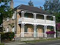
The house, known as Boongarre or Boongaree was built in the 1870s. It was owned by the Stead family from 1918 to 1980 and is sometimes known as Stead House. It was later acquired by the soccer player Mark Schwarzer. In 2011, Woollahra Council voted to confirm the heritage status of the house. [17] It is now listed on the council's heritage list. [18]

Population

At the 2021 census, 883 people were recorded in Watsons Bay. [19]

In the 2016 census, there were 850 people in Watsons Bay. 64.6% of people were born in Australia and 78.0% of people only spoke English at home. The most common responses for religion were No Religion 33.8% and Catholic 19.2%. [20]

Landmarks

Camp Cove, Watsons Bay Watsons Bay - Camp Cove Beach, Sydney 2 - Nov 2008.jpg
Camp Cove, Watsons Bay

Watsons Bay is a mostly residential area with some recreational areas and beaches, including Camp Cove and a legal nude beach located at Lady Bay. Some restaurants, cafes and a hotel are located here. The coastal walk with ocean views of the Gap along South Head make Watsons Bay a popular tourist attraction in Sydney. The Sydney Harbour Pilot Boat Station was located on the bay, and the naval training base HMAS Watson is located nearby at South Head.

Heritage listings

Watsons Bay has a number of heritage-listed sites, including:

Watsons Bay has a large number of heritage buildings, with the following buildings listed on the (now defunct) Register of the National Estate: [22] Many buildings and structures are also listed as heritage items by Woollahra Council. [18]

Events

Every Man and His Dog is an annual event held in Watsons Bay on Australia Day (January 26), where men and their dogs team up on the same stand-up paddle board and race other dog lovers. [25] Many of the participants dress up in matching dog and owner costumes. [25]

Attractions

Watsons Bay, NSW Watsons Bay - panoramio - Maksym Kozlenko (6).jpg
Watsons Bay, NSW

Notable people

Notable people from or who have lived in Watsons Bay include:

Related Research Articles

<span class="mw-page-title-main">Port Jackson</span> Body of water in Sydney, Australia

Port Jackson, consisting of the waters of Sydney Harbour, Middle Harbour, North Harbour and the Lane Cove and Parramatta Rivers, is the ria or natural harbour of Sydney, New South Wales, Australia. The harbour is an inlet of the Tasman Sea. It is the location of the Sydney Opera House and Sydney Harbour Bridge. The location of the first European settlement and colony on the Australian mainland, Port Jackson has continued to play a key role in the history and development of Sydney.

<span class="mw-page-title-main">Rose Bay, New South Wales</span> Suburb of Sydney, New South Wales, Australia

Rose Bay is a harbourside, eastern suburb of Sydney, in the state of New South Wales, Australia. Rose Bay is located seven kilometres east of the Sydney central business district, in the local government areas of Waverley Council and Municipality of Woollahra.

<span class="mw-page-title-main">Eastern Suburbs (Sydney)</span> Region in New South Wales, Australia

The Eastern Suburbs is the eastern metropolitan region of Sydney, New South Wales, Australia.

<span class="mw-page-title-main">Double Bay</span> Suburb of Sydney, New South Wales, Australia

Double Bay is a harbourside eastern suburb of Sydney, in the state of New South Wales, Australia 4 kilometres east of the Sydney central business district. It is the administrative centre of the local government area of the Municipality of Woollahra.

<span class="mw-page-title-main">Paddington, New South Wales</span> Suburb of Sydney, Australia

Paddington is an upscale Eastern Suburb of Sydney, in the state of New South Wales, Australia. Located 3 kilometres (1.9 mi) east of the Sydney central business district, Paddington lies across two local government areas. The portion south of Oxford Street lies within the City of Sydney, while the portion north of Oxford Street lies within the Municipality of Woollahra. It is often colloquially referred to as "Paddo".

<span class="mw-page-title-main">Macquarie Lighthouse</span> Lighthouse in New South Wales, Australia

The Macquarie Lighthouse, also known as South Head Upper Light, is the first, and is the longest serving, lighthouse site in Australia. It is located on Dunbar Head, on Old South Head Road, Vaucluse in the Municipality of Woollahra local government area of New South Wales, Australia. The lighthouse is situated approximately 2 kilometres (1 mi) south of South Head near the entrance to Sydney Harbour. There has been a navigational aid in this vicinity since 1791 and a lighthouse near the present site since 1818. The current heritage-listed lighthouse was completed in 1883. The lighthouse and associated buildings were designed by James Barnet and built from 1881 to 1883.

<span class="mw-page-title-main">Vaucluse, New South Wales</span> Suburb of Sydney, New South Wales, Australia

Vaucluse is an eastern suburb of Sydney, in the state of New South Wales, Australia. It is located 8 kilometres (5 mi) east of the Sydney central business district, in the local government areas of Waverley Council and the Municipality of Woollahra.

<span class="mw-page-title-main">Municipality of Woollahra</span> Local government area in New South Wales, Australia

Woollahra Municipal Council is a local government area in the eastern suburbs of Sydney, in the state of New South Wales, Australia. Woollahra is bounded by Sydney Harbour in the north, Waverley Council in the east, Randwick City in the south and the City of Sydney in the west.

<i>Dunbar</i> (ship) Sailing ship built in 1853, wrecked in 1857

The Dunbar was a full-rigged ship designed and built from 1852 to 1853 by James Laing & Sons of Deptford Yard in Sunderland, England and used for maritime trade, as a troop ship and transport. The Dunbar was wrecked near the entrance to Sydney Harbour, Australia in 1857 with the loss of 121 lives. The wreck of the Dunbar ranks as one of Australia's worst maritime disasters, with the event still retained in the social history of Sydney and New South Wales.

<span class="mw-page-title-main">Sydney Heads</span> Headlands around Sydney Harbour

The Sydney Heads are a series of headlands that form the 2 km (1.2 mi) wide entrance to Sydney Harbour in Sydney, New South Wales, Australia. North Head and Quarantine Head are to the north; South Head and Dunbar Head are to the south; and Middle Head, Georges Head, and Chowder Head are to the west and within the harbour. The Heads are contained within the Sydney Harbour National Park.

<span class="mw-page-title-main">Hornby Lighthouse</span> Lighthouse in New South Wales, Australia

Hornby Lighthouse, also known as South Head Lower Light or South Head Signal Station, is a heritage-listed active lighthouse located on the tip of South Head, New South Wales, Australia, a headland to the north of the suburb Watsons Bay. It marks the southern entrance to Port Jackson, as well as lighting the South Reef, a ledge of submerged rocks. It is the third oldest lighthouse in New South Wales. Designed by Mortimer Lewis and listed on the Register of the National Estate and on the New South Wales State Heritage Register since 2 April 1999, with the following statement of significance:

A dominant Sydney landmark which appears to have been in continuous use since the 1840s as a controlling point for shipping entering and leaving Port Jackson. The building complex, designed by the Colonial Architect Mortimer Lewis in the early 1840s, is an architectural important example of an early Victorian public work associated with port activities.

<span class="mw-page-title-main">Trams in Sydney</span> History of the tramway system closed in Sydney NSW Australia

The Sydney tramway network served the inner suburbs of Sydney, Australia, from 1879 until 1961. In its heyday, it was the largest in Australia, the second largest in the Commonwealth of Nations, and one of the largest in the world. The network was heavily worked, with about 1,600 cars in service at any one time at its peak during the 1930s . Patronage peaked in 1945 at 405 million passenger journeys. Its maximum street trackage totalled 291 km in 1923.

<span class="mw-page-title-main">The Gap (Sydney)</span> Ocean cliff on the South head of Sydney Harbour, New South Wales, Australia

The Gap is an ocean cliff at South Head in the Eastern Suburbs of Sydney, Australia. The area, which faces the Tasman Sea, is located in the suburb of Watsons Bay. Although the cliff is a popular tourist destination, it has infamy for suicides.

<span class="mw-page-title-main">New South Head Road</span> Road in Sydney, Australia

New South Head Road is a major road in the Eastern Suburbs of Sydney, linking the inner-eastern suburb of Rushcutters Bay to the southern reaches of the South Head peninsula.

<span class="mw-page-title-main">Mosman, New South Wales</span> Suburb of Sydney, New South Wales, Australia

Mosman is a suburb on the Lower North Shore region of Sydney, in the state of New South Wales, Australia. Mosman is located 8 kilometres north-east of the Sydney central business district and is the administrative centre for the local government area of the Municipality of Mosman.

<span class="mw-page-title-main">Old South Head Road</span> Road in Sydney, Australia

Old South Head Road is a major road in Sydney, linking the eastern suburb of Bondi Junction to Watsons Bay on the South Head peninsula. It is historically significant because its earliest origins can be traced back to the early days of the colony of New South Wales.

<span class="mw-page-title-main">South Head General Cemetery</span> Historic site in New South Wales, Australia

The South Head General Cemetery is a heritage-listed cemetery located at 793 Old South Head Road, Vaucluse, New South Wales, Australia. It was built from 1845 to 1950. It is also known as Old South Head Cemetery and the South Head Cemetery. The property is Crown Land governed by Waverley Municipal Council. It was added to the New South Wales State Heritage Register on 25 August 2017.

<span class="mw-page-title-main">Rose Bay Sea Wall</span> Historic site in New South Wales, Australia

Rose Bay Sea Wall is a heritage-listed former Aboriginal land, farms and road reserve and now sea wall, road reserve and esplanade at New South Head Road, Rose Bay, New South Wales, Australia. It was designed by Herbert E. Ross and built from 1924 to 1926 by Woollahra Municipal Council. It is also known as Rose Bay Sea Wall, Promenade and its setting. It was added to the New South Wales State Heritage Register on 22 August 2014.

<i>Vaucluse</i> (ferry)

Vaucluse was a ferry on Sydney Harbour that served on the Circular Quay to Watsons Bay run. She was launched in 1905, and was one of the fastest ferries in Sydney. She was sent to Newcastle after which her fate is unknown. She was named after the Sydney suburb, Vaucluse.

<span class="mw-page-title-main">Municipality of Vaucluse</span> Former local government area in New South Wales, Australia

The Municipality of Vaucluse was a local government area of Sydney, New South Wales, Australia. The municipality was proclaimed as the "Borough of Vaucluse" on 1 May 1895, seceding from the Municipality of Woollahra, and included the modern suburbs of Vaucluse and Watsons Bay. The council was re-amalgamated with Woollahra to the south with the passing of the Local Government (Areas) Act 1948.

References

  1. Australian Bureau of Statistics (28 June 2022). "Watsons Bay (suburb and locality)". Australian Census 2021 QuickStats. Retrieved 28 June 2022.  OOjs UI icon edit-ltr-progressive.svg
  2. Derricourt, Robin (2008). "Watsons Bay". The Dictionary of Sydney. Archived from the original on 2 May 2014. Retrieved 1 May 2014.
  3. 1 2 3 4 "History". Watsons Bay Association. Retrieved 1 February 2022.
  4. Selkirk Provis, J.; Johnson, K. A. (1972). Cadman's Cottage. The life and times of John Cadman; In colonial Sydney; 1798 - 1848 (1st ed.). Privately published. p. 23. ISBN   0-9599711-1-4.
  5. Watson, Captain J. H. (23 November 1929). "The Watsons of Watson's Bay". The Sydney Morning Herald . NSW. p. 13. Archived from the original on 16 April 2024. Retrieved 9 February 2012 via Trove.
  6. 1 2 3 Pollon, Frances, ed. (1990). The Book of Sydney Suburbs. Australia: Angus & Robertson Publishers. p. 265. ISBN   0-207-14495-8.
  7. Kidman, John (29 March 2008). "Green light for Gap safety Cameras to alert police". The Sydney Morning Herald . Retrieved 30 March 2008.
  8. 1 2 "Dunbar Group". New South Wales State Heritage Register . Department of Planning & Environment. H01675. Retrieved 2 June 2018. CC BY icon.svg Text is licensed by State of New South Wales (Department of Planning and Environment) under CC-BY 4.0 licence .
  9. Jervis, J. (1960). Kelly, V. (ed.). The History of Woollahra, Sydney. Sydney: Woollahra Municipal Council.
  10. Drain Grate, Rose Bay. Heritage, Roads and Traffic Authority. Retrieved 22 August 2007.
  11. 1 2 Gap Park History - NSW Government
  12. Gill, George Hermon (1968). Royal Australian Navy, 1942–1945, p 65
  13. Stevens, David (2005). A Critical Vulnerability, p 193
  14. Kennedy, David (December 2003). Tully, A. P. (ed.). "The Midget Submarine Attack against Sydney: May 1942". Imperial Japanese Navy Mysteries. Imperial Japanese Navy Page. Archived from the original on 4 June 2023.
  15. Walking Coastal Sydney
  16. Sydney Morning Herald, 11 September 2015, p. 15
  17. Woollahra Council Website
  18. 1 2 Woollahra Council Website
  19. "2021 Watsons Bay, Census All persons QuickStats". Australian Bureau of Statistics. Archived from the original on 19 February 2023. Retrieved 18 August 2022.
  20. Australian Bureau of Statistics (27 June 2017). "Watsons Bay (State Suburb)". 2016 Census QuickStats. Retrieved 30 October 2017. OOjs UI icon edit-ltr-progressive.svg
  21. "South Head Signal Station". New South Wales State Heritage Register . Department of Planning & Environment. H01436. Retrieved 18 May 2018. CC BY icon.svg Text is licensed by State of New South Wales (Department of Planning and Environment) under CC-BY 4.0 licence .
  22. The Heritage of Australia, Macmillan Company, 1981, pp.2/135-137
  23. "St Peter's Anglican Church". New South Wales Heritage Database. Office of Environment & Heritage . Retrieved 2 November 2019.
  24. «A zoological station» // «The Australasian Sketcher», Saturday 12 March 1881, p. 94
  25. 1 2 Kane, Dominique. "Every Man and His Dog: Stand Up Paddle Board Race" . Retrieved 22 April 2015.
  26. "Watsons Bay Tourism". 16 May 2017. Retrieved 16 May 2017.

33°50′33.9″S151°16′52.5″E / 33.842750°S 151.281250°E / -33.842750; 151.281250