Parramatta is a major CBD and a suburb in Greater Western Sydney, located in New South Wales, Australia. It is located approximately 24 kilometres (15 mi) west of Central Sydney, on the banks of the Parramatta River. Parramatta is the administrative seat of the local government area of the City of Parramatta and is often regarded as one of the city centres of the Greater Sydney Metropolitan area, alongside with Sydney, Penrith, Liverpool, etc. Parramatta also has a long history as a second administrative centre in the Sydney metropolitan region, playing host to a number of state government departments as well as state and federal courts. It is often colloquially referred to as "Parra".

Darlinghurst is an inner-city, suburb in the eastern suburbs of Sydney, New South Wales, Australia. Darlinghurst is located immediately east of the Sydney central business district (CBD) and Hyde Park, within the local government area of the City of Sydney. It is often colloquially referred to as "Darlo".

Philip Gidley King was a British politician who was the third Governor of New South Wales.

Glebe is an inner-western suburb of Sydney in New South Wales. Glebe is located 3 kilometres (1.9 mi) southwest of the Sydney central business district and is part of the local government area of the City of Sydney, in the Inner West region.
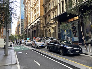
Pitt Street is a major street in the Sydney central business district in New South Wales, Australia. The street runs through the entire city centre from Circular Quay in the north to Waterloo, although today's street is in two disjointed sections after a substantial stretch of it was removed to make way for Sydney's Central railway station. Pitt Street is well known for the pedestrian only retail centre of Pitt Street Mall, a section of the street which runs from King Street to Market Street.

George Street is a street in the central business district of Sydney.

Broadway is a 700-metre (2,300 ft) road in inner city Sydney, New South Wales, Australia. The road constitutes the border between the suburbs of Ultimo and Chippendale. Broadway is also an urban locality.

King Street is the central thoroughfare of the suburb of Newtown in Sydney, Australia. The residents of the area, including a higher-than-average concentration of students, LGBT people and artists, are most visible on this street, sealing Newtown's reputation as Sydney's premier hub of subcultures. The street can be divided geographically into two sections, North and South. King Street is particularly notable for the many picturesque Victorian era and Edwardian era commercial buildings that line the street.

Macquarie Street is a street in the central business district of Sydney in New South Wales, Australia. Macquarie Street extends from Hyde Park at its southern end to the Sydney Opera House at its northern end. Apart from connecting these two major landmarks, the key government institutions of the state of New South Wales are all located on this street.

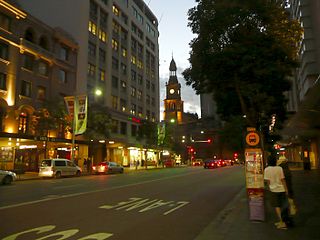
St James' Church, commonly known as St James', King Street, is an Australian heritage-listed Anglican parish church located at 173 King Street, in the Sydney central business district in New South Wales. Consecrated in February 1824 and named in honour of St James the Great, it became a parish church in 1835. Designed in the style of a Georgian town church by the transported convict architect Francis Greenway during the governorship of Lachlan Macquarie, St James' is part of the historical precinct of Macquarie Street which includes other early colonial era buildings such as the World Heritage listed Hyde Park Barracks.
Park Street is a street in the central business district of Sydney in New South Wales, Australia. It runs from George Street in the west to College Street in the east, where it becomes William Street.

College Street is a 700-metre (2,300 ft) major street in the central business district of Sydney in New South Wales, Australia. From north to south, it runs from east of Queens Square and St James station to start at the junction of the Prince Albert, St Marys, and Art Gallery roads and runs to Whitlam Square, at Liverpool Street. The street gets its name from a college on the street, St. Mary’s Cathedral College. The street runs beside the eastern border of Hyde Park, and is lined by the Australian Museum, Sydney Grammar School, Cook and Phillip Park Aquatic and Fitness Centre, St Mary's Cathedral, and Australian International College.
Stanley Street is a small street in the East Sydney locale, which is part of the suburb of Darlinghurst, Sydney, New South Wales.

Harris Street is the main thoroughfare in the Inner West suburbs of Pyrmont and Ultimo in Sydney, New South Wales, Australia. It runs from the northern tip of the Pyrmont peninsula to Broadway in the central business district. Harris Street was formerly lined by industrial sites such as the Ultimo Power Station, Ultimo Tram Depot and the Government Printing Office.
Cleveland Street is a busy thoroughfare located to the south of the central business district of Sydney in New South Wales, Australia. The street is named after Captain Cleveland, an officer of the 73rd regiment.

Bathurst Street is a street in the Sydney central business district in New South Wales, Australia. Bathurst Street runs for 650 metres (2,130 ft) in a west–east direction with traffic flowing in this direction only. It is situated in the southern portion of the central business district. The western terminus of Bathurst Street is at Harbour Street, Darling Harbour, with the eastern terminus at Elizabeth Street, adjacent to Hyde Park.

Phillip Street is a street in the central business district of Sydney in New South Wales, Australia. While the street runs from King Street in the south to Circular Quay in the north, the present street is effectively in two sections, separated by Chifley Square. Other cross streets include Martin Place, Bridge Street, and Bent Street. It is the hotspot of Sydney's legal elite.

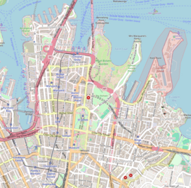
Queen's Square is a public square in central Sydney, Australia. The square is located at the junction of King Street with Phillip Street and Macquarie Street. It is bounded on the south by St James Road and Prince Albert Road.

Bridge Street is a street in the central business district of Sydney in New South Wales, Australia. Bridge Street runs for 500 metres (1,600 ft) in a west–east direction with traffic flowing in both directions. It is situated in the northern portion of the central business district. The western terminus of Bridge Street is at George Street, with the eastern terminus at Macquarie Street, adjacent to the Chief Secretary's Building. From west to east, Bridge Street crosses Pitt and Phillip streets.

The former Banco Court of the Supreme Court of New South Wales is a heritage-listed courthouse at St James Road, Sydney, Australia. It was designed by Walter Liberty Vernon and built from 1895 to 1896. It forms part of the historic complex known sometimes as the "St James Law Courts" or the "King Street Courts". The property is owned by the Department of Justice, a department of the Government of New South Wales. It was added to the New South Wales State Heritage Register on 2 April 1999.