
The Powerhouse Museum is the major branch of the Museum of Applied Arts & Sciences (MAAS) in Sydney, the others being the historic Sydney Observatory at Observatory Hill, and the newer Museums Discovery Centre at Castle Hill. Although often described as a science museum, the Powerhouse has a diverse collection encompassing all sorts of technology including decorative arts, science, communication, transport, costume, furniture, media, computer technology, space technology and steam engines.

Glebe is an inner-western suburb of Sydney. Glebe is located 3 kilometres (1.9 mi) southwest of the Sydney central business district and is part of the local government area of the City of Sydney, in the Inner West region.

George Street is a street in the central business district of Sydney.

Broadway is a 700-metre (2,300 ft) road in inner city Sydney, New South Wales, Australia. The road constitutes the border between the suburbs of Ultimo and Chippendale. Broadway is also an urban locality.
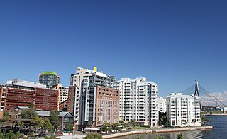
Pyrmont is an inner-city suburb of Sydney, in the state of New South Wales, Australia 2 kilometres south-west of the Sydney central business district in the local government area of the City of Sydney. It is also part of the Darling Harbour region. As of 2011, it is Australia's most densely populated suburb.

Ultimo is an inner-city suburb of Sydney, New South Wales, Australia. Ultimo is located 2 kilometres south-west of the Sydney central business district in the local government area of the City of Sydney.

The Pyrmont Bridge, a heritage-listed swing bridge across Cockle Bay, is located in Darling Harbour, part of Port Jackson, west of the central business district in the City of Sydney local government area of New South Wales, Australia. Opened in 1902, the bridge initially carried motor vehicle traffic via the Pyrmont Bridge Road between the central business district and Pyrmont. Since 1981 the bridge has carried pedestrian and bicycle traffic only, as motor vehicles were diverted to adjacent freeway overpasses. The bridge was added to the New South Wales State Heritage Register on 28 June 2002, the centenary of its opening.

The Sydney tramway network served the inner suburbs of Sydney, Australia from 1879 until 1961. In its heyday, it was the largest in Australia, the second largest in the Commonwealth of Nations, and one of the largest in the world. The network was heavily worked, with about 1,600 cars in service at any one time at its peak during the 1930s . Patronage peaked in 1945 at 405 million passenger journeys. Its maximum street trackage totalled 291 km in 1923.

The Western Distributor is a 3.8-kilometre-long (2.4 mi) grade-separated motorway that is primarily elevated for the majority of its route on the western fringe of the Sydney central business district in New South Wales, Australia. From its northern terminus, it links the southern end of the Bradfield Highway at the Sydney Harbour Bridge to Victoria Road in Rozelle, at its western terminus near White Bay. The freeway is designated as part of the A4 for its entire distance.
The North Western Expressway and the Lane Cove Valley Expressway was a planned but now cancelled freeway route in Sydney, New South Wales, Australia, intended to link the Sydney CBD to its north-western suburbs, and ultimately the Sydney–Newcastle Freeway to Newcastle. The entirety of the Sydney to Newcastle route was to be known as the F3 freeway, a name that remains as a common name of the Sydney–Newcastle Freeway.

Market Street is a street in the city centre of Sydney in New South Wales, Australia. It runs from Sussex Street near Darling Harbour in the west, to Elizabeth Street at St. James railway station in the east.
West Sydney was an electoral district for the Legislative Assembly in the Australian State of New South Wales created in 1859 from part of the electoral district of Sydney, covering the western part of the current Sydney central business district, Ultimo and Pyrmont, bordered by George Street, Broadway, Bay Street and Wentworth Park. It elected four members simultaneously, with voters casting four votes and the first four candidates being elected. For the 1894 election, it was replaced by the single-member electorates of Sydney-Gipps, Sydney-Lang, Sydney-Denison and Sydney-Pyrmont.
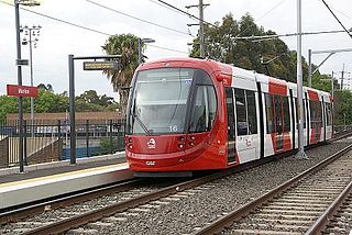
The Inner West Light Rail is a 12.8-kilometre (8.0 mi) light rail line in Sydney, New South Wales, Australia, running from Central railway station through the Inner West to Dulwich Hill and serving 23 stops. The line is currently closed for investigations following cracks discovered on the LRVs. It is the original line of the Sydney light rail network, and was originally known as Sydney Light Rail. Light rail services on the line are now branded as the L1 Dulwich Hill Line.

Ultimo Tram Depot was part of the Sydney tram network.
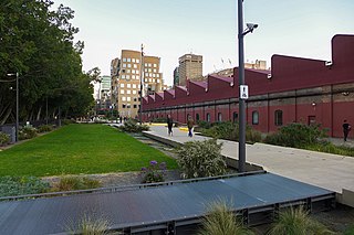
The Goods Line is an 800 m-long (2,625 ft) linear park and shared pedestrian pathway and cycleway in the suburb of Ultimo, in the City of Sydney, New South Wales, Australia. The corridor connects Railway Square to Darling Harbour in the south and passes both the University of Technology Sydney Broadway campus and the Australian Broadcasting Corporation Sydney head office. The Goods Line terminates in the north at the corner of Sussex and Hay Streets, in the Sydney central business district.

Pyrmont Post Office is a heritage-listed former post office and now bank branch office located at 148 Harris Street, in the inner city Sydney suburb of Pyrmont in the City of Sydney local government area of New South Wales, Australia. It was designed by the Government Architect’s Office under Walter Liberty Vernon. The property is owned by Australia Post, an agency of the Commonwealth Government of Australia. It was added to the Australian Commonwealth Heritage List on 22 June 2004 and to the New South Wales State Heritage Register on 22 December 2000.
The Ultimo Post Office is a heritage-listed former post office located at 494 Harris Street in the inner city Sydney suburb of Ultimo in the City of Sydney local government area of New South Wales, Australia. The property is owned by Trustees of the Museum of Applied Arts and Science, an agency of the Government of New South Wales. It was added to the New South Wales State Heritage Register on 2 April 1999.

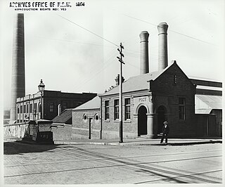
The Ultimo Sewage Pumping Station is a heritage-listed sewerage pumping station located at William Henry Street in the inner city Sydney suburb of Ultimo in the City of Sydney local government area of New South Wales, Australia. As a result of the construction of an elevated roadway along William Henry Street, the pumping station now fronts Pyrmont Street, with vehicles being required to enter via Quarry Street, then turning right into Pyrmont Street.

The urban renewal of Sydney is an ongoing land redevelopment process that is creating and reviving new urban centres across Sydney, Australia. Urban renewal refers to the refurbishment of derelict buildings, streets or neighbourhoods and is accompanied with the process of gentrification attributed by changes in land use and deindustrialisation of areas. In 2020, there are several projects underway and planned including Barangaroo, The Bays Precinct and Green Square.
Darling Harbour Yard was a goods railway yard in Darling Harbour, New South Wales, Australia. The yard was once the origin of all outgoing goods traffic from Sydney. After closing to heavy rail in 1993, the alignment of the Metropolitan Goods line which passed through it was reutilised by light rail. The precinct around the yard has been significantly redeveloped since the closure.

