Pyrmont, New South Wales

Last updated

Pyrmont
Sydney,  New South Wales
Appartment buildings near Pirrama Park, Sydney, Australia - looking towards ANZAC Bridge (35265182890) (cropped).jpg
Pyrmont from Pirrama Park
Pyrmont, New South Wales
Map
Australia New South Wales location map blank.svg
Red pog.svg
Pyrmont
Coordinates 33°52′30″S151°11′47″E / 33.87497°S 151.19635°E / -33.87497; 151.19635
Population12,658 (SAL 2021) [1]
Postcode(s) 2009
Area1 km2 (0.4 sq mi)
Location2 km (1 mi) west of Sydney CBD
LGA(s) City of Sydney
Parish St Andrew
State electorate(s) Sydney
Federal division(s) Sydney
Suburbs around Pyrmont:
Balmain Balmain East Millers Point
Rozelle Pyrmont Darling Harbour
Glebe Ultimo Haymarket
Pyrmont wharves 1pyrmont wharfs.jpg
Pyrmont wharves

Pyrmont is an inner-city suburb of Sydney, in the state of New South Wales, Australia 2 kilometres south-west of the Sydney central business district in the local government area of the City of Sydney. It is also part of the Darling Harbour region. As of 2011, it is Australia's most densely populated suburb. [2]

Contents

Pyrmont was once a vital component of Sydney's industrial waterfront, with wharves, shipbuilding yards, factories and woolstores. As industry moved out, the population and the area declined. In recent years it has experienced redevelopment with an influx of residents and office workers.

History

Pyrmont contained a mineral spring of cold water bubbling out of a rock and was thus named for a similar natural spring in Bad Pyrmont, close to Hanover, Germany. [3] Thomas Jones was granted 55 acres (22 ha) of land on the peninsula in 1795. Land was sold to Obadiah Ikin in 1796 for 10 pounds, which he then sold to Captain John Macarthur in 1799 for a gallon of rum. [4]

Pyrmont was the site of quarries from a fairly early stage because of the quality of the sandstone. Charles Saunders, licensee of the Quarryman's Arms hotel, became the biggest quarrymaster, with three quarries established in the area from 1853. The work was continued by his son and grandson till circa 1931. The quarries were nicknamed Paradise, Purgatory and Hell Hole by the Scottish workers employed by Saunders. Steam-powered equipment was used there for the first time in Australia. The sandstone was used in many of the most significant buildings in Sydney. [5] Saunders Street, near the site of the Paradise quarry, was named after Saunders.

Maybanke Kindergarten, named after Maybanke Anderson, in Harris Street (1)Former Methodist Chapel Harris Street Pyrmont.jpg
Maybanke Kindergarten, named after Maybanke Anderson, in Harris Street

The area was also the site of the first Presbyterian Church in the colony, built in 1864 and situated in Mount Street. [6] The congregation eventually outgrew the premises and had to move to a new church at Quarry Street, Ultimo, in 1883. [7] In the 1870s, a small Methodist chapel was built in Harris Street on land owned by Charles Saunders. In the 1920s, it was converted to the Maybanke Free Kindergarten, named after Maybanke Anderson, a feminist and educationist. It was still used for that purpose as of 2018.

Pyrmont became a working class industrial and port community. A major sugar refinery was operated by CSR Limited. In 1900 the area had a population of around 30,000. [8] The first Pyrmont Bridge opened in 1858. A larger bridge with a swinging span opened in 1902, but was closed to traffic in the 1980s. It was subsequently turned into a pedestrian precinct. In 1973, a public meeting held between residents of Pyrmont and Ultimo asked the Builders Labourers Federation imposed a green ban on the North Western Expressway to save much of the suburb. [9]

Decay

Pyrmont was regarded as a slum area in the late 19th century. [10] It started to decay seriously after World War II, when industries closed down, and the residents moved to the suburbs. In 1963 the Ultimo Powerhouse closed down as well. Its population declined to only 1,800 by 1978. [8]

By 1990 the population had dropped to around 900.

Redevelopment in the 1990s

In order to rejuvenate the area the government initiated the Better Cities Program. In 1992 the City West Development Corporation had been created with the mission to renew the precinct. In 1999 this responsibility has been transferred to the Sydney Harbour Foreshore Authority. [11]

This led to a larger community of 13,000 by 2004 and also an increase of trade with businesses moving back into the area, totalling 22,000 employees. [11] Almost all industrial function is gone from the area now, replaced by low and high-rise residential developments. The sugar refinery closed down and some of the buildings, including The Cooperage and Tablet House, were restored as residential and office space. Both are listed on the local government heritage register. [12] [13]

Following the redevelopment the suburb became more multicultural, with only 35% of residents born in Australia, followed by 8% born in China. [11]

Landmarks

Pyrmont Fire Station in Pyrmont Street is designed by the Government Architect, Walter Liberty Vernon, in 1907. It is an example of the Federation Free Style, predominantly made of brick with sandstone trimmings, and with Art Nouveau elements. It is now on the (now defunct) Register of the National Estate. [14]

The public school in John Street was designed by W.E.Kemp and built in 1891; a brick building, it features a bell tower, belfry and slate roof, and is on the defunct Register of the National Estate. [14] As of 2015, the building is used by a childcare and the Pyrmont Community Center.

Union Square is a major heritage precinct. It includes the Post Office in Harris Street, The Harlequin Inn pub, two bank buildings in Union Street, the homes from 4-20 Union Street, all buildings from 99 to 125 Harris Street, the terrace from 135 to 141 Harris Street and terraces from 1-21 Paternoster Row. All of these buildings are listed on the defunct Register of the National Estate. [15] Also on the defunct Register is the Waite and Bull building at 137 Pyrmont Bridge Road. [14]

Heritage listings

Pyrmont tunnel John St Square station from inside west portion of Pyrmont tunnel.jpg
Pyrmont tunnel

Pyrmont has a number of heritage-listed sites, including:

Commercial areas

The Star casino dominates the Darling Harbour waterfront of Pyrmont and the Sydney Fish Market is located on Blackwattle Bay. Jacksons Landing is a residential and commercial property development located on the northern part of the peninsula. [22]

Pyrmont is home to the headquarters of several corporations including Vodafone, Accenture Australia, Network 10, Google [23] and radio stations Nova 96.9, Smooth 95.3, and 2SM. Pyrmont is the former home to Seven West Media (moved to Australian Technology Park at Eveleigh in 2017) and 2GB (moved to North Sydney in 2020).

Pyrmont pano from Darling Island.jpg
Panoramic view of Pyrmont from the REVY C rooftop on Darling Island, with Jones Bay Wharf at right

Population

Historical population
YearPop.±%
20017,861    
200611,088+41.1%
201111,618+4.8%
201612,813+10.3%
202112,658−1.2%

At the 2021 census, 12,658 people were living in Pyrmont. [24] In the 2016 census, there were 12,813 people in Pyrmont. [25]

In 2021, 40.7% of people were born in Australia. The other most common countries of birth were China 6.2%, England 4.2%, India 4.0%, Thailand 2.5% and New Zealand 2.2%. 52.6% of people only spoke English at home. Other languages spoken at home included Mandarin 6.9%, Cantonese 4.3%, Spanish 3.3%, Thai 2.6% and Indonesian 1.6%. The most common responses for religion were No Religion 43.6% and Catholic 18.6%. 93.7% of dwellings were flats, units or apartments and 5.7% are semi-detached terraced houses or townhouses. [24]

Transport

Road transport

Pyrmont is linked to the city by the Pyrmont Bridge, a swing bridge for pedestrians and cyclists. The Western Distributor passes through the suburb and provides a connection to the city and then to the North Shore via the Sydney Harbour Bridge. The Distributor includes the Anzac Bridge, a large cable-stayed bridge spanning Johnstons Bay between Pyrmont and Rozelle, which replaced the Glebe Island Bridge.

Light rail

The Inner West Light Rail includes five light rail stops in the suburb - Pyrmont Bay, The Star, John Street Square, Fish Market and Wentworth Park. The Pyrmont Bay ferry wharf is served by Pyrmont Bay ferry services. Pyrmont is also served by buses.

Pyrmont was served by the former Sydney tramway network. Services commenced at Railway Square, travelling southwest on Broadway, turning right onto Harris Street, passing the former Darling Harbour Goods Yard. At Pyrmont a separate line branched off from the main line on Harris Street, turning left into Miller Street, turning right into Bank Street, crossing the former Glebe Island Bridge. It then travelled along Commercial Road turning right onto Victoria Road, then right onto Darling Street, terminating at the Darling Street wharf. [26] The tram lines closed in 1958. The Sydney Monorail ran between the city and nearby Darling Harbour across the Pyrmont Bridge between 1988 and 2013.

Heavy rail

Pyrmont is a future rapid transit station that will be built as part of the Sydney Metro West project. [27]

Parks

Pyrmont Point Park (left) and Anzac Bridge (background), 2009 CSIRO ScienceImage 8028 The tug Wombi near the entry to Darling Harbour.jpg
Pyrmont Point Park (left) and Anzac Bridge (background), 2009
Crushed sugar cane defibrator balls at Waterfront Park Wood chip digester balls at Waterfront Park.jpg
Crushed sugar cane defibrator balls at Waterfront Park

St Bartholomew's Park is a small park on the corner of Bowman Street and Cross Street, created in 1954 after the demolition of numbers 113-115 Bowman Street. The park is named after St Bartholomew's Church which once stood nearby on Point Street (now a block of apartments at 22 Point Street).

Pirrama Park (previous known as Pyrmont Point Park) is located in the northern tip of the peninsula, overlooking Balmain East, and extends southwest along the coast to Elizabeth Macarthur Bay and the beginning of Harris Street, along Pirrama Road. The land was previously a base for the Water Police; the City of Sydney acquired it in 2005 and developed the area into a 1.8ha recreational space, with cafes, barbeque facilities and children's play equipment. [28]

Giba Park sits atop the cliff overlooking Pirrama Park.

Waterfront Park is near the western extreme of the suburb, near the Glebe Island Bridge.

Other parks in Pyrmont include The Knoll, Carmichael Park, Jones Street Pocket Park, Ballaarat Park, Metcalfe Park, Pyrmont Bay Park, Bank Street Foreshore Park, and Refinery Square. [29]

Related Research Articles

<span class="mw-page-title-main">Darling Harbour</span> Harbour adjacent to the city centre of Sydney, New South Wales, Australia

Darling Harbour is a harbour adjacent to the city centre of Sydney, New South Wales, Australia that is made up of a large recreational and pedestrian precinct that is situated on western outskirts of the Sydney central business district.

<span class="mw-page-title-main">Port Jackson</span> Body of water in Sydney, Australia

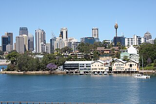
Port Jackson, consisting of the waters of Sydney Harbour, Middle Harbour, North Harbour and the Lane Cove and Parramatta Rivers, is the ria or natural harbour of Sydney, New South Wales, Australia. The harbour is an inlet of the Tasman Sea. It is the location of the Sydney Opera House and Sydney Harbour Bridge. The location of the first European settlement and colony on the Australian mainland, Port Jackson has continued to play a key role in the history and development of Sydney.

<span class="mw-page-title-main">Ryde, New South Wales</span> Suburb of Sydney, New South Wales, Australia

Ryde is a suburb of Sydney, New South Wales, Australia. Ryde is located 13 km north-west of the Sydney central business district and 8 km east of Parramatta. Ryde is the administrative centre of the local government area of the City of Ryde and part of the Northern Sydney region. It lies on the north bank of the Parramatta River. People from Ryde are colloquially known as Ryders, Rydiens or Rydemen.

<span class="mw-page-title-main">Glebe, New South Wales</span> Suburb of Sydney, New South Wales, Australia

Glebe is an inner-western suburb of Sydney in New South Wales. Glebe is located 3 kilometres (1.9 mi) southwest of the Sydney central business district and is part of the local government area of the City of Sydney, in the Inner West region.

<span class="mw-page-title-main">Ultimo, New South Wales</span> Suburb of Sydney, New South Wales, Australia

Ultimo is an inner-city suburb of Sydney, New South Wales, Australia. It is adjacent to the Sydney central business district in the local government area of the City of Sydney west of the Darling Harbour area, and is bordered by Pyrmont to the north, the Sydney CBD and Chinatown/Haymarket to the east, Broadway and Chippendale to the south, and Glebe and Wentworth Park to the west.

<span class="mw-page-title-main">Rozelle</span> Suburb of Sydney, New South Wales, Australia

Rozelle is a suburb in the inner west of Sydney, in the state of New South Wales, Australia. It is located 4 kilometres west of the Sydney central business district, in the local government area of the Inner West Council.

<span class="mw-page-title-main">Pyrmont Bridge</span> Heritage-listed bridge across Cockle Bay in Sydney, Australia

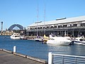
The Pyrmont Bridge, a heritage-listed swing bridge across Cockle Bay, is located in Darling Harbour, part of Port Jackson, west of the central business district in the City of Sydney local government area of New South Wales, Australia. Opened in 1902, the bridge initially carried motor vehicle traffic via the Pyrmont Bridge Road between the central business district and Pyrmont. Since 1981 the bridge has carried pedestrian and bicycle traffic only, as motor vehicles were diverted to adjacent freeway overpasses. The bridge was added to the New South Wales State Heritage Register on 28 June 2002, the centenary of its opening.

<span class="mw-page-title-main">Glebe Island Bridge</span> Swing Allan truss road bridge in Sydney, Australia

The Glebe Island Bridge is a heritage-listed disused swing Allan truss road bridge that carried Victoria Road across Johnstons Bay, located in the inner city Sydney suburb of Pyrmont in the City of Sydney local government area of New South Wales, Australia. The bridge, that connected Rozelle to Pyrmont by road, is one of the last remaining swing bridges of its type in Australia and in the world. It was designed by Percy Allan and built from 1899 to 1903 by Bridges Branch of NSW Public Works Department. It is also known as RMS Bridge No. 61. It was added to the New South Wales State Heritage Register on 29 November 2013 and was listed on the Register of the National Estate on 19 April 1989.

<span class="mw-page-title-main">Darling Point</span> Suburb of Sydney, New South Wales, Australia

Darling Point is a harbourside eastern suburb of Sydney, Australia. It is 4 kilometres east of the Sydney central business district and is part of the local government area of Woollahra Council.

<span class="mw-page-title-main">Balmain East</span> Suburb of Sydney, New South Wales, Australia

Balmain East is a suburb in the Inner West of Sydney, in the state of New South Wales, Australia. Balmain East is located three kilometres west of the Sydney central business district, in the local government area of the Inner West Council.

<span class="mw-page-title-main">Birchgrove, New South Wales</span> Suburb of Sydney, New South Wales, Australia

Birchgrove is a suburb in the Inner West of Sydney, in the state of New South Wales, Australia. Birchgrove is located five kilometres west of the Sydney central business district, in the local government area of the Inner West Council.

<span class="mw-page-title-main">Glebe Island</span>

Glebe Island was a major port facility in Sydney Harbour and, in association with the adjacent White Bay facility, was the primary receiving venue for imported cars and dry bulk goods in the region until 2008. It is surrounded by White, Johnstons, and Rozelle Bays. Whilst retaining its original title as an "island", it has long been infilled to the shoreline of the suburb of Rozelle and connected by the Glebe Island Bridge to Pyrmont.

George Allen Mansfield was a prominent Australian architect of the nineteenth century who designed many iconic buildings in Sydney, New South Wales, Australia.

<span class="mw-page-title-main">Pyrmont Post Office</span> Historic site in New South Wales, Australia

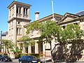
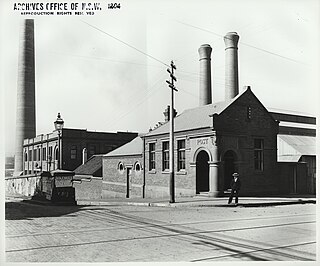
Pyrmont Post Office is a heritage-listed former post office and now bank branch office located at 148 Harris Street, in the inner city Sydney suburb of Pyrmont in the City of Sydney local government area of New South Wales, Australia. It was designed by the Government Architect’s Office under Walter Liberty Vernon. The property is owned by Australia Post, an agency of the Commonwealth Government of Australia. It was added to the Australian Commonwealth Heritage List on 22 June 2004 and to the New South Wales State Heritage Register on 22 December 2000.

<span class="mw-page-title-main">Ultimo Road railway underbridge</span> Bridge in New South Wales, Australia

The Ultimo Road railway underbridge is a heritage-listed former railway bridge located on the former Darling Harbour goods railway line in the inner city Sydney suburb of Ultimo in the City of Sydney local government area of New South Wales, Australia. It was designed by engineering staff in the Existing Lines branch of the New South Wales Public Works Department and built in 1879. The property is owned by Transport Asset Holding Entity, an agency of the Government of New South Wales. It was added to the New South Wales State Heritage Register on 2 April 1999.

<span class="mw-page-title-main">Ultimo Post Office</span> Historic site in New South Wales, Australia

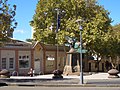
The Ultimo Post Office is a heritage-listed former post office located at 494 Harris Street in the inner city Sydney suburb of Ultimo in the City of Sydney local government area of New South Wales, Australia. The property is owned by Trustees of the Museum of Applied Arts and Science, an agency of the Government of New South Wales. It was added to the New South Wales State Heritage Register on 2 April 1999.

<span class="mw-page-title-main">Ultimo Sewage Pumping Station</span> Historic site in New South Wales, Australia

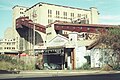
The Ultimo Sewage Pumping Station is a heritage-listed sewerage pumping station located at William Henry Street in the inner city Sydney suburb of Ultimo in the City of Sydney local government area of New South Wales, Australia. As a result of the construction of an elevated roadway along William Henry Street, the pumping station now fronts Pyrmont Street, with vehicles being required to enter via Quarry Street, then turning right into Pyrmont Street.

<span class="mw-page-title-main">Pyrmont and Glebe railway tunnels</span>

The Pyrmont and Glebe railway tunnels are heritage-listed railway tunnels, once part of the Metropolitan Goods railway line, Pyrmont and Glebe, New South Wales, Australia. The tunnels now carry the Inner West Light Rail line. The property is owned by Transport Asset Holding Entity, a state government agency. The tunnels were added to the New South Wales State Heritage Register on 2 April 1999.

<span class="mw-page-title-main">Old Pyrmont Cottages</span> Historic site in New South Wales, Australia

Old Pyrmont Cottages is a heritage-listed cottage at 1, 3, 5 Cross Street in the inner city Sydney suburb of Pyrmont in the City of Sydney local government area of New South Wales, Australia. It was built from 1879 to 1895. It is also known as Cross & Scott Street Terraces. The property is owned by the Sydney Harbour Foreshore Authority (SHFA). It was added to the New South Wales State Heritage Register on 25 August 2017.

<span class="mw-page-title-main">Glebe and Wentworth Park railway viaducts</span> Bridge in New South Wales, Australia

The Glebe and Wentworth Park railway viaducts are a series of two heritage-listed railway bridges and arch viaducts that carry the Inner West Light Rail across Wentworth Park, Jubilee Park, and Johnstons Creek in the inner western Sydney suburb of Glebe in the City of Sydney local government area of New South Wales, Australia. They were designed by the New South Wales Government Railways and built from 1892 to 1922 by day labour. They are also known as Wentworth Park Viaduct, Jubilee Park Viaduct and Glebe Viaducts. The viaducts were added to the New South Wales State Heritage Register on 2 April 1999.

References

  1. Australian Bureau of Statistics (28 June 2022). "Pyrmont (suburb and locality)". Australian Census 2021 QuickStats. Retrieved 28 June 2022.  OOjs UI icon edit-ltr-progressive.svg
  2. Packed-in Pyrmont is Australia's most densely populated suburb Archived 7 June 2013 at the Wayback Machine . News.domain.com.au. Retrieved on 2 August 2013.
  3. The Book of Sydney Suburbs, Frances Pollon, (Angus and Robertson) 1990, page 213
  4. Early Pyrmont Archived 30 September 2007 at the Wayback Machine Powerhouse Museum
  5. "What's On". Archived from the original on 5 April 2017. Retrieved 10 June 2017.
  6. "Mustard Seed". Archived from the original on 27 February 2015. Retrieved 10 June 2017.
  7. "MustardSeed Ultimo Uniting Church" . Retrieved 10 June 2017.
  8. 1 2 Bounds, Michael and Morris, Alan: High-rise gentrification: the redevelopment of Pyrmont Ultimo, in Urban Design International, nr.10, 2005
  9. "List of green bans, 1971-1974". libcom.org. Retrieved 16 October 2019.
  10. Cable, K. J. "Boyce, Francis Bertie (1844–1931)". Australian Dictionary of Biography. National Centre of Biography, Australian National University. Archived from the original on 7 July 2017. Retrieved 10 June 2017 via Australian Dictionary of Biography.
  11. 1 2 3 "Sydney Harbour Foreshore Authority: Ultimo+Pyrmont - A Decade of Renewal, 2004" (PDF). Archived (PDF) from the original on 13 June 2009. Retrieved 1 May 2011.
  12. "Former CSR Cooperage Building Including Interiors and Industrial Archaeology". New South Wales Heritage Database. Office of Environment & Heritage . Retrieved 10 June 2017.
  13. "Former CSR Tablet House Including Interiors". New South Wales Heritage Database. Office of Environment & Heritage . Retrieved 10 June 2017.
  14. 1 2 3 The Heritage of Australia, Macmillan Company, 1981, p.2/88
  15. The Heritage of Australia, pp.86-88
  16. "Pyrmont Post Office (Place ID 105510)". Australian Heritage Database . Australian Government . Retrieved 23 September 2018.
  17. "Pyrmont Post Office". New South Wales State Heritage Register . Department of Planning & Environment. H01440. Retrieved 18 May 2018. CC BY icon.svg Text is licensed by State of New South Wales (Department of Planning and Environment) under CC-BY 4.0 licence .
  18. "Glebe Island Bridge". New South Wales State Heritage Register . Department of Planning & Environment. H01914. Retrieved 18 May 2018. CC BY icon.svg Text is licensed by State of New South Wales (Department of Planning and Environment) under CC-BY 4.0 licence .
  19. "Old Pyrmont Cottages". New South Wales State Heritage Register . Department of Planning & Environment. H01986. Retrieved 18 May 2018. CC BY icon.svg Text is licensed by State of New South Wales (Department of Planning and Environment) under CC-BY 4.0 licence .
  20. "Pyrmont and Glebe Railway Tunnels". New South Wales State Heritage Register . Department of Planning & Environment. H01225. Retrieved 18 May 2018. CC BY icon.svg Text is licensed by State of New South Wales (Department of Planning and Environment) under CC-BY 4.0 licence .
  21. "Royal Edward Victualling Yard". New South Wales State Heritage Register . Department of Planning & Environment. H01855. Retrieved 18 May 2018. CC BY icon.svg Text is licensed by State of New South Wales (Department of Planning and Environment) under CC-BY 4.0 licence .
  22. "Pyrmont - Sydney City". Destination NSW. Archived from the original on 9 March 2016. Retrieved 9 March 2016.
  23. "Google Offices Archived 15 August 2013 at the Wayback Machine ." Google. Retrieved 25 May 2016. "Google Sydney Google Australia Pty Ltd. Level 5, 48 Pirrama Road, Pyrmont, NSW 2009 Australia"
  24. 1 2 Australian Bureau of Statistics (28 June 2022). "Pyrmont". 2021 Census QuickStats. Retrieved 5 December 2022. OOjs UI icon edit-ltr-progressive.svg
  25. Australian Bureau of Statistics (27 June 2017). "Pyrmont (State Suburb)". 2016 Census QuickStats. Retrieved 29 June 2017. OOjs UI icon edit-ltr-progressive.svg
  26. Gregory's Street Directory, 1955, Map 6, 2, 1
  27. "New Metro Station for Pyrmont". Transport for NSW. 11 December 2020. Retrieved 11 December 2020.
  28. "Locations > Pirrama Park". Pyrmont History Group. Retrieved 30 March 2024.
  29. "Society > Parks and Playgrounds". Pyrmont History Group. Retrieved 30 March 2024.